
Corrine Brown1, Olivia Godber1, Kirsten Workman1,2, Kitty O’Neil3, Josh Hornesky4, Quirine Ketterings1
1Nutrient Management Spear Program, 2PRODAIRY, Cornell University, Ithaca, NY 14853, 3Cornell Cooperative Extension North Country Regional Ag Team, 4USDA-Natural Resources Conservation Service, NY
Introduction
Tillage practices can impact soil greenhouse gas (GHG) emissions, soil carbon (C) sequestration and overall soil health. Tools are available to estimate whole farm GHG inventories (N2O, CO2, and CH4 emissions), field-based emissions, and C sequestration or loss. These tools often require a user to classify tillage intensity. The Natural Resources Conservation Service (NRCS) GHG accounting system uses the Revised Universal Soil Loss Equation (RUSLE2) to calculate a Soil Tillage Intensity Rating (STIR) that can be used to classify the intensity of various tillage practices. This tool also classifies tillage intensity based on percent residue surface cover and soil disturbed. This article explains what a STIR factor is, describes how to determine percent surface residue cover, and categorize different tillage practices into tillage intensity classifications.
Soil Tillage Intensity Rating (STIR)
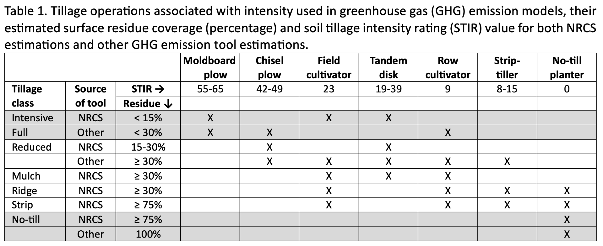
The STIR value of a field can range from 0-200 with high values for intense tillage (Table 1). The STIR is based on four components: tillage type, depth of operation, operational speed, and percent of soil surface area disturbed.
-
- Tillage type: This describes how a tillage pass mixes soil and crop residue. Tillage disturbance operations can include inversion and some mixing of soil, mixing and some (limited) inversion, lifting and fracturing, mixing only, and soil compression.
- Depth of operation: The depth to which soil disturbance and residue incorporation occur.
- Operational speed of tillage: This is the recommended operating speed of each tillage operation. The forward speed of a tillage implement impacts soil disturbance and mixing; faster speeds result in more significant forces and broader disturbance.
- Percent of soil surface area disturbed: The percentage of surface soil disturbed by the tillage pass.
 Estimating Percent Residue Cover
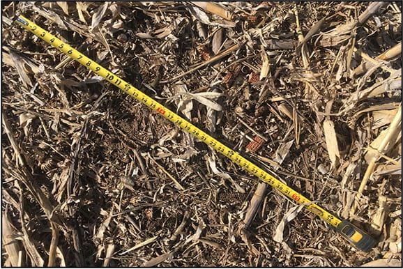
Percent residue cover remaining on the surface following a tillage operation can be determined using the RUSLE2 equation or measured in the field using the line transect method. The line transect uses a line measuring tool (a rope or tape measure) that has 100 equally distributed and easily viewed marks (Figure 1). Typically, the measuring tool is 100 feet long with markings at 1-foot intervals or 50 feet long with marking at 6-inch intervals. To determine the percent residue surface cover of a field, stretch the tool diagonally across crop rows in a direction that is at least 45 degrees off the row direction and count the number of markings that have crop residue directly present beneath. Residue smaller than 1/8 inch in diameter should not be counted. The total count (markings with residue beneath them) is the percent residue cover for the field. This process should be repeated at least three times in different areas of the field and percentages should be averaged.
https://www.sdsoilhealthcoalition.org/ soil-health-assessment-card/).
NRCS Tillage Intensity Classes
The NRCS tool groups tillage practices into six categories; intensive, reduced, mulch, ridge, strip, and no-till:
-
- Intensive tillage is full width tillage that inverts soil with high disturbance. Common equipment includes a moldboard plow.
- Reduced tillage occurs at full width without soil inversion, using a point chisel plow, field cultivator and/or tandem disk.
- Mulch tillage a single pass across the field using tools such as a tandem disk followed by field or row cultivator or similar implement.
- Ridge tillage creates soil ridges in the field that are rebuilt during cultivation by disturbing up to 1/3 of the row width. The soil is then undisturbed from harvest to planting.
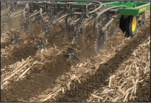
- Strip tillage leaves the soil between crop rows undisturbed (Figure 2). To create a seedbed, up to 1/3 of the row width is disturbed.
- No-till operations plant crop seeds directly through residue of the previous crop using a no-till planter or drill.
Full vs. Reduced vs. No-Till
Some GHG footprint assessment tools categorize tillage practices differently, using three main categories; full, reduced, and no-till:
-
- Full tillage contributes to significant soil disturbance, fully inverting the soil (as is done with moldboard plowing) and/or performing tillage operations frequently in the same year using tools like chisel plows or row cultivators.
- Reduced tillage also disturbs the soil but does not fully invert the soil. Examples include onetime use of chisel plows, field cultivators, tandem disks, row cultivators, or strip-tillers.
- No-till practices directly drill crop seed through the residue layer with little to no disturbance to the soil. Minimal disturbance occurs in the area where seeds are planted. Common operations use a no-till planter.
In Summary
Tools available to assess whole-farm and field-based GHG inventories and C sequestration or loss require the user to classify tillage intensity. Choosing the tillage description that best fits the producers’ management practices is essential for accurately assessing GHG emissions.
Additional Resources
-
- Tillage Equipment Pocket Identification Guide. Natural Resources Conservation Service (NRCS). https://nydairyadmin.cce.cornell.edu/uploads/doc_21.pdf
- Estimating Residue Using the Line-Transect Method. A3533. University of Wisconsin Extension.http://corn.agronomy.wisc.edu/Management/pdfs/A3533.pdf
Acknowledgements
This article is available as part of the Cornell Nutrient Management Spear Program (NMSP) Factsheet Series: http://nmsp.cals.cornell.edu/publications/factsheets/factsheet126.pdf. Corrine Brown was an undergraduate intern with NMSP, funded by a gift from Chobani. For questions, contact Quirine M. Ketterings (qmk2@cornell.edu) or visit the NMSP website at: http://nmsp.cals.cornell.edu/.