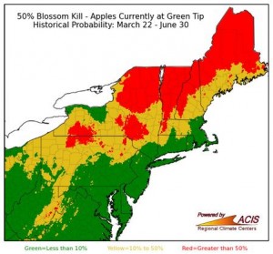
The warm winter and March has accelerated apple development—the Northeast Regional Climate Center (NRCC) developed a new product highlighting the climatological risk of apple blossom kill for different growth stages. These regional risk maps can be viewed at http://www.nrcc.cornell.edu/industry/apple/apple.html and selecting the Seasonal Kill Risk option corresponding to the current growth stage of your orchard.
The maps show the historical (1979-2015) probability of experiencing a minimum temperature capable of killing a bud during the period from the present day through June 30. The three maps reflect critical temperatures capable of killing 10%, 50% and 90% of the buds. Since lethal temperatures increase as bud development progresses, separate sets of maps are given for each growth stage (green tip, 1/2″ green, tight cluster, pink, bloom, and petal fall). Select the Seasonal Kill Risk maps that reflect the current growth stage of trees in your orchard to consult the historical climate probability of critical temperatures occurring through June 30.

50% blossom kill risk map for green tip on 3/21/2016.
The colors on the maps reflect the kill-producing temperature probabilities. Red indicates that more than 50% of the historical years saw a temperature, between the day you access the tool and June 30, that would result in the bud kill percent for that risk map. In yellow areas, between 10% and 50% of the historical years saw a temperature, between the day you access the tool and June 30, which would have resulted in bud kill. Green areas indicate where less than 10% of historical years saw temperatures that would have caused a kill event.
The maps will be updated daily around 5:00 am.
The NRCC values your suggestions regarding this product. Please feel free to email any suggestions to nrcc@cornell.edu using the subject line apple blossom kill maps.
Post contributed by: Art DeGaetano, Professor of Earth and Atmospheric Sciences and Director of NOAA Northeast Regional Climate Center, Cornell University