The U.S. Drought Monitor released July
14, 2016 showed 23% of the Northeast
in a drought. Drought Advisory’s and Drought Watch’s have been declared, and voluntary and mandatory water restrictions have been implemented in the region. The current drought is expected to be seasonal and is focused in three main areas. Drought conditions have occurred in Essex County, MA seven of the past 17 years, with a drought every year since 2012. Tompkins County, NY, is experiencing a severe drought for the first time since the U.S. Drought Monitor began in 2000. Bergen County, NJ has experienced drought conditions nine of the past 17 years, with extreme drought in 2002.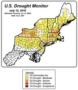
Large areas of New York, Vermont, New Hampshire, New Jersey, and Pennsylvania have had less than three quarters of their normal March through June precipitation amounts. The U.S. Geological Survey (USGS) preliminary data showed waterways in parts of New England, New York, Pennsylvania, and northern New Jersey were running below or well below normal levels in late June and early July.
USDA reports from early July showed topsoil moisture rated short or very short for 51% of New York and 60% of New England, while subsoil moisture rated short or very short for 47% of New York and 56% of New England. Many farms need irrigation to prevent the dry conditions from hindering growth, stressing crops, and reducing yield. For example, pastures were stunted and corn was curling in parts of central New York. Several farms in northeastern Massachusetts reported crop losses due to non-irrigated fields being too dry to plant or seeds not emerging after planting.
The Climate Prediction Center’s Monthly Drought Outlook for July calls for drought conditions to persist or develop in parts of the Northeast. NEWA products and linked resources are available to assist in decision making during these conditions.
Apps and info to help you, from NEWA’s main menu, under Crop Management, include:
- Cornell Apple ET Model, an app for managing irrigation in apple orchards.
- Apple Evapotranspiration Table, an estimate of water use by an apple tree (liters/day) for airport locations in NY.
- Evapotranspiration Map from ForeCast and the Northeast Regional Climate Center (NRCC), an estimate of potential evapotranspiration (PET) in turfgrass.
- Other Crop Tools page or on the Home page, under Other Crop Management Tools in the left-hand side bar:
- Drought Monitoring, from NOAA – the Palmer Drought Index, provides access to several drought monitoring products and historical records.
- U.S. Drought Monitor Map, the map is based on measurements of climatic, hydrologic and soil conditions as well as reported impacts and observations from more than 350 contributors around the country.
- U.S. Drought Outlook Map, depicts current large-scale trends of drought based on statistical and dynamical forecasts.
This post was contributed by Jessica Spaccio, Climatologist, Northeast Regional Climate Center and Dept of Earth and Atmospheric Sciences, Cornell University, jlr98@cornell.edu.