
NOAA Northeast Regional Climate Center, Cornell University
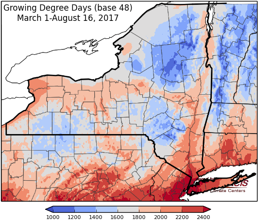
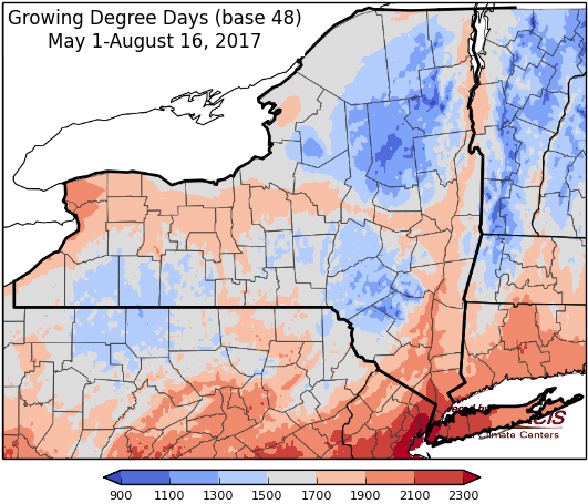
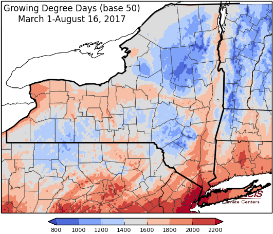
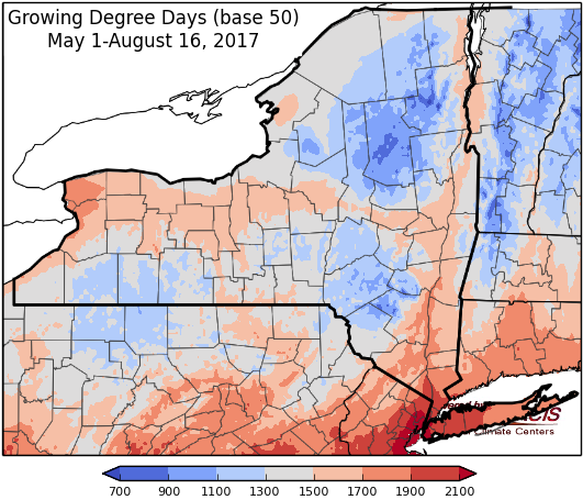
Last week temperatures ranged within 2 degrees of normal. Precipitation ranged from less than a quarter inch to 2 inches for most of the state. Base 50 growing degree-days ranged from 80 to 160.
Frontal systems will bring showers and thunderstorms Thursday into Friday. Sunday & Monday will be sunny and dry. The next system moves through Tuesday evening into Wednesday.
Today temperatures will be in the upper 70’s to mid 80’s. A frontal system will bring increasing clouds and a chance for showers and thunderstorms in the afternoon into the night, with heavy rain possible overnight. Overnight lows will be in the upper 50’s to upper 60’s.
Friday temperatures will be in the mid 70’s to low 80’s, with scattered showers and thunderstorms. There is a possibility of sever storms with hail, strong winds, and locally heavy rainfall. Overnight temperatures will be in the 60’s.
Saturday’s highs will be in the mid 70’s to mid 80’s with scattered showers possible. Overnight temperatures will be in the upper 50’s to mid 60’s.
Sunday will by sunny and dry with highs in the upper 70’s to mid 80’s. Overnight temperatures will be in the upper 50’s to low 60’s.
Monday’s highs will be in the 80’s with sunny conditions. Lows will be in the low to mid 60’s.
Tuesday will have temperatures throughout 80’s. Lows will be in the low to mid 60’s. Showers and thunderstorms will develop overnight and continue into Wednesday with a passing cold front.
Wednesday, temperatures will be in the upper 70’s to mid 80’s with showers and thunderstorms. Lows will be in low to mid 60’s.
The seven-day precipitation amounts will range from ½ ” to near 2”.
The 8-14 day outlook (Aug 24-30) slightly favors below-normal temperatures for western to north-central and southeast NY. The precipitation outlook slightly favors below-normal precipitation amounts for western NY to northeast NY.
Maps of 8-14 day outlooks:
http://www.cpc.ncep.noaa.gov/products/predictions/814day/index.php
National Weather Service watch/warnings map:
http://www.weather.gov/erh/
US Drought Monitor
http://droughtmonitor.unl.edu/Home.aspx
CLIMOD2 (NRCC data interface):
http://climodtest.nrcc.cornell.edu
