
From Jessica Spaccio, NOAA Northeast Regional Climate Center, Cornell University
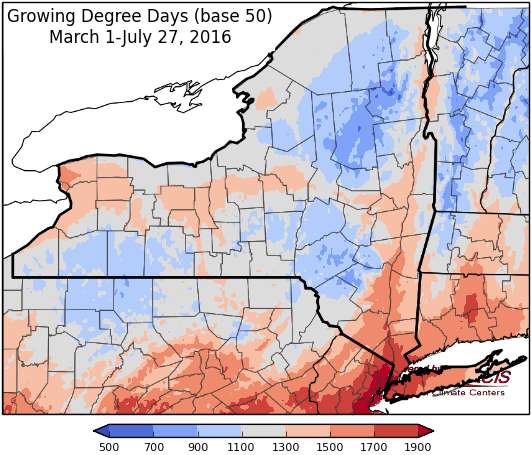
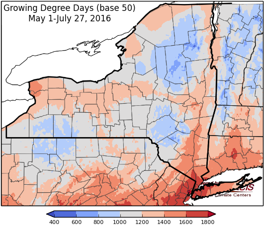
Last week temperatures ranged from 2 to 6 degrees above normal for most of the state. Precipitation ranged from a tenth to 2 inches. Base 50 growing degree-days ranged from 120 to 180.


Some unsettled weather brings hope for rain, temperatures heating up again next week…
Today will be hot & humid, a cold front will bring isolated showers and thunderstorms with temperatures in the upper 70’s and 80’s. Overnight lows will be in the 60’s to low 70’s.
Friday showers and non-severe thunderstorms will bring locally heavy rain to eastern portions of the state with highs in the mid 70’s to mid 80’s. Lows will be in the mid 50’s to 60’s.
Saturday will be dry with temperatures will be in the mid 70’s and 80’s. Overnight temperatures will be in the mid 50’s to mid 60’s with a chance for showers and thunderstorms.
Sunday there will be a continued chance of showers and thunderstorms with highs in the mid 70’s to mid 80’s. Overnight temperatures will be in the upper 50’s to mid 60’s.
Monday the highs will be in the upper 70’s to mid 80’s. Lows will be in the mid 50’s to mid 60’s.
Tuesday temperatures will be 80’s to near 90. Lows will be in the upper 50’s to mid 60’s.
Wednesday temperatures will be in the mid 80’s to low 90’s. Lows will be in the 60’s.
The five-day precipitation amounts will range from 1/10 ” to 2.5”, with the highest amounts in southeast NY .
The 8-14 day outlook (August 4-10) shows equal chances for above or below normal temperatures for most of the state, an increased chance (33-40%) for above normal temperatures for southeast and southwest NY. There is an increased chance (40-50%) for below normal precipitation for the entire state.
The Drought Monitor: There has been a slight expansion of severe drought in central NY and moderate drought in the Hudson Valley. U.S. Department of Agriculture (USDA) rating topsoil moisture at least half short to very short on July 24 New York (54%). Drought was also apparent in low streamflows, particularly across western New York. Buffalo, New York, received 1.80 inches of rain during the first 26 days of July, 68% of normal, following its driest April-June period since 1941. Buffalo’s precipitation totaled just 4.42 inches (44% of normal) in April-June 2016.
Maps of 8-14 day outlooks:
|http://www.cpc.ncep.noaa.gov/products/predictions/814day/index.php
National Weather Service watch/warnings map:
http://www.weather.gov/erh/
US Drought Monitor:
http://droughtmonitor.unl.edu/Home.aspx
CLIMOD2 (NRCC data interface):
http://climodtest.nrcc.cornell.edu
