Jessica Spaccio, NOAA Northeast Regional Climate Center, Cornell University
Weather Outlook – June 4, 2014
NOAA Northeast Regional Climate Center, Cornell University
Last week temperatures ranged from 2 degrees below normal in eastern NY to 4 degrees above normal in western NY. Precipitation ranged from just a trace to an inch. Base 50 growing degree-days ranged from 50 to 110, less than 50 in the Adirondack region.

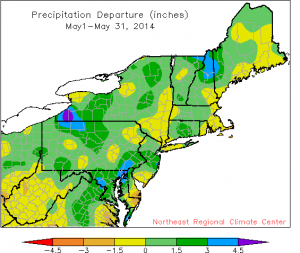
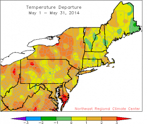
 The month of May finished with temperatures ranging from 0-3 degrees above normal. A majority of the state had 0-1.5” above normal precipitation, but some areas had over 3” above normal while others were below normal.
Cooler and rain for some on Thursday; sunny and dry Friday and Saturday. Another chance for showers and thunderstorms Sunday into Monday.
Today will start sunny but clouds will increase; highs will be in the 70’s with only a slight chance of showers. Overnight showers are possible with lows in the mid 40’s to 50’s.
Thursday will be cloudy and cooler with highs in the low 60’s to low 70’s. A low-pressure system tracking east will bring showers and thunderstorms mostly to the southern and eastern edge of the state. Overnight temperatures will be in the 40’s to mid 50’s.
Friday any remaining showers will move out and there will be partly sunny skies with temperatures in the upper 60’s and low 70’s. Lows will be in the upper 40’s to mid 50’s.
Saturday will be mostly sunny and dry with highs in the mid 70’s to low 80’s. Overnight temperatures will be in the 50’s.
Sunday will be partly cloudy with highs in the low to mid 80’s; chance for scattered showers in western NY from an approaching warm front. Lows will be in the upper 50’s and low 60’s with chance of storms overnight.
Monday will be mostly cloudy with a chance of scattered showers accompanying a warm front; highs will be in the mid to upper 70’s. Lows will be in the upper 50’s to low 60’s.
Tuesday will be in the low to mid 70’s scattered showers. Lows will be in the 50’s.
The five-day precipitation amounts will range from ¼” – ½” for most, ½” – ¾” for southern/eastern NY ; 7-day amounts will range from ½” – ¾” for most, ¾” – 1” for southern/eastern NY.
The 8-14 day outlook (Jun 11-17) is showing below normal temperatures for the Castskills and southern Hudson Valley and above normal precipitation for the entire state.
Maps of 8-14 day outlooks: http://www.cpc.ncep.noaa.gov/products/predictions/814day/index.php
National Weather Service watch/warnings map: http://www.erh.noaa.gov/er/hq/
NRCC Drought Page which features the US Drought Monitor map (updated every Thursday): http://www.nrcc.cornell.edu/page_drought.html

