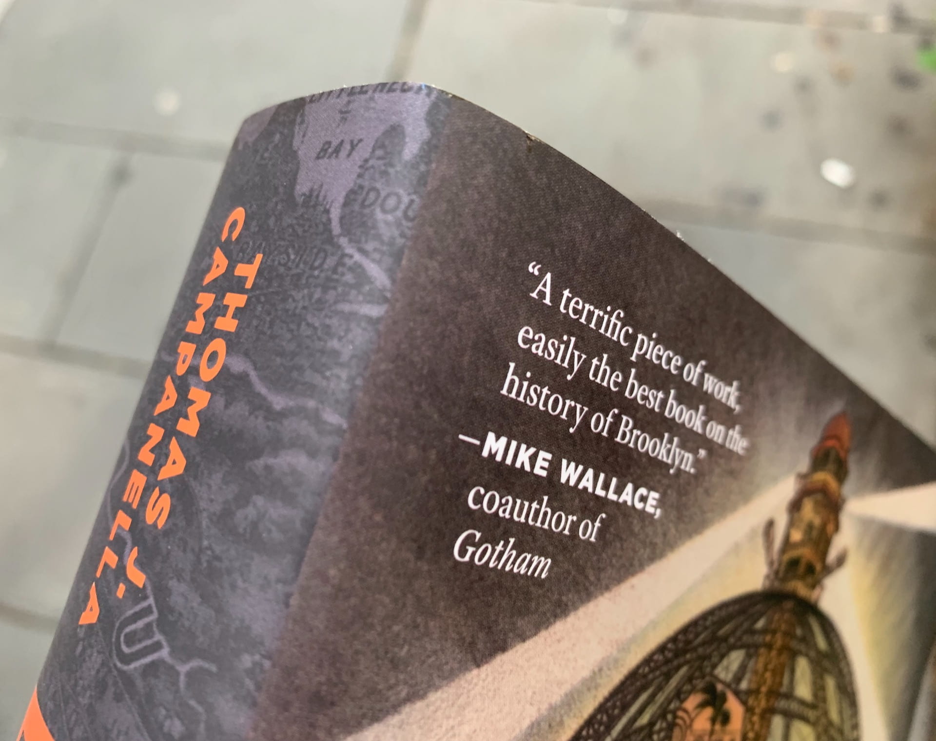
BROOKLYN: THE ONCE AND FUTURE CITY
First bound copy of my new book! It will be released in mid September. Click here for more info . . .

First bound copy of my new book! It will be released in mid September. Click here for more info . . .
[THIS ESSAY APPEARED IN NEW YORK MAGAZINE ON 23 JULY, 2019]
Few New Yorkers would consider the Brooklyn-Queens Expressway an outstanding example of urban design, but the quarter-mile section at Columbia Heights is just that: an industrial-Deco masterwork, a brief note of harmony in the otherwise grim tale of the automobile and the city. Here, a major highway briefly becomes a good urban citizen: Traffic is channeled onto great stacked trays that step down to the waterfront, as if genuflecting before Manhattan; up top floats one of New York’s finest open spaces, the Brooklyn Heights promenade. This rare fusion of highway design and civic urbanism makes the recent decision to repair rather than replace the vast cantilevered structure a praiseworthy one.

It’s long been Heights lore that the viaduct and promenade were the fruits of an extraordinary organizing effort by local residents, one that handed the titanic Robert Moses a rare defeat. Moses, the story goes, hungered to cleave the fine old neighborhood with his nasty road. And, in fairness, it certainly looked like he was about to do just that.
My parents courted on the Brooklyn Heights Promenade in the 1950s, which means I might not exist were it not for the project. But the very road that helped lead my mother to the altar also destroyed the neighborhood she grew up in. Marriage got her out of impoverished Vinegar Hill, and not a moment too soon, for the coming of the BQE unleashed — there and along much of its ten-mile route — a cycle of decline that wasn’t reversed until the 1990s.
Trenched across working-class South Brooklyn, the expressway hacked apart neighborhoods already battered by the loss of port and manufacturing jobs. It laid waste to the North Heights, taking with it February House — the storied rookery where Carson McCullers, Benjamin Britten, and W. H.
Auden lived in splendid chaos. It consumed entire blocks for bridge ramps, crushed the daylight out of Park Avenue by the Navy Yard, and cleared a swath of Williamsburg wide enough to land a jumbo jet. Lewis Mumford likened it all to “the blast of an atom bomb.”
This was oddly appropriate. The Brooklyn-Queens Connecting Highway, as it was initially known, was intended to complete a great orbital route around the city that Moses had a begun a decade earlier with the Circumferential Parkway (today’s Belt, Southern, Laurelton, and Cross Island parkways). It would extend that loop via the elevated Gowanus Expressway toward Queens and the Grand Central Parkway. Ever creative in tapping federal coffers, Moses positioned the BQE as vital to “the defense of New York City in war,” part of a $65 million highway program announced on Armistice Day in 1940. He envisioned “ponderous units of mobile war machines” rolling down his roads.
Because the BQE had run along Hicks Street in South Brooklyn — today’s Cobble Hill and Carroll Gardens — many assumed that Moses would march north on the same trajectory, driving the highway right up the Heights’s Anglo-Dutch arse. As any child with a map could see, Hicks Street was the most direct route between this latter-day Sherman and his sea. Or so it seemed.
Indeed, nothing would have made Moses happier than to beat the superior shit out of the Heights. Moses had already clashed with the community over one of his dream projects: a Brooklyn-Battery bridge. At the behest of Heights friends, First Lady Eleanor Roosevelt decried the proposed span as an “eyesore perpetrated in the name of progress” in her popular New YorkWorld-Telegram column. He built a tunnel instead.
After all, this was no immigrant ghetto that quaked at the command of City Hall but one of the most exclusive neighborhoods in New York. And while its glory days were well past, Brooklyn Heights in the 1940s still had real clout — the soft-spoken, old-money clout of club and boardroom. A list of Columbia Heights residents at the time reads like a page from the Social Register — Sturgis, Talmadge, Hamilton, Fairbanks, Parke, Hale, Edwards. There is not an ethnic name among them. Most Heights folk did not mingle with Jews in the 1940s; they were certainly not going to be bossed around by one.
They could be hoodwinked, though.
Aside from a self-serving quip years later — that he was talked out of going “through the Heights” by Borough President John Cashmore — there is no evidence that Moses seriously meant to run the BQE up Hicks Street. If this alignment was considered at all, it was only briefly in the project’s early vetting stages; for taking Hicks Street would have not only been politically costly but also required condemning “very expensive property and churches,” as Moses engineer Ernest J. Clark put it.
But Moses was a Machiavellian with a penchant for grudges, and like a cat with a mouse under its paw, he was going to have a little fun. In early September 1942, surveyors were seen fiddling with theodolites and transit rods on Hicks Street. The Heights was set abuzz like a drop-kicked hornet’s nest. The Brooklyn Heights Press pulled out its biggest font typeface to DENOUNCE EXPRESS HIGHWAY, which left its readers “shocked beyond recovery.”
In all likelihood, Moses ordered the Hicks Street survey simply to provoke the Heights, fanning its worst-case fears so that almost any alternative would be embraced by relieved and grateful residents. That “alternative” they got was the one Moses wanted from the start — along the embankment at Furman Street. That he did so was hardly a secret. A map in the Triborough Bridge Authority’s Gowanus Improvement report, published a year before the Hicks Street survey, clearly indicates the BQE running along the Heights waterfront. Months earlier, in a June 1941 Times article about the Gowanus Parkway, Borough President Cashmore explained that the city intended “to extend this express highway route … by way of Furman Street to a connection with the Brooklyn, Manhattan and Meeker Avenue bridges.” The City Planning Commission, too, had selected the Furman Street route as early as 1939, with site planner Fred W. Tuemmler retained to design a cantilevered highway structure with the upper road at roughly the level of Columbia Heights (though sans promenade or even sidewalks).
Heights residents cheered. Local civic and business organizations unanimously backed the “new” route at the sole planning-commission hearing on the project in March 1943. Local elites convinced themselves it was timely action on their part that saved the day. One was typewriter heiress Gladys Underwood James. According to the late Henrik Krogius, James hosted a “dinner of persuasion” for Moses at her Pierrepont Place home, where she informed her guest “that the [Hicks] route would be fatal to the neighborhood … that the highway must be put along Furman Street.” The problem is that James did not move to the Heights until 1948, long after construction at Furman Street had begun.
By bluffing the Heights, Moses minted political capital that diffused opposition to other aspects of the huge project: the promenade, for example. Homeowners on Columbia Heights, the most exclusive block in Brooklyn, had long opposed a public park in their backyards. In 1827, pioneering developer Hezekiah Pierrepont proposed “an open promenade … from Fulton ferry to Joralemon Street” but was rebuffed by his own neighbors. In 1903, again to no avail, the New-York Tribune promoted construction of an “imposing park or terrace” above Furman Street to afford people “an unobstructed view of New-York Harbor.” Eight years later, Newell Dwight Hillis of Plymouth Church — a keen advocate of city planning — suggested building “a boulevard one hundred feet wide, on the level of the gardens in the rear of the Columbia Heights houses.” Hillis had a true bully pulpit and yet no one heeded his call.
Robert Moses at his best — Moses the reformer, man of the people; Moses before World War II — was a latter-day Robin Hood who relished taking from the rich and giving to the poor (the “deserving” white poor, at least). The promenade was born out of the last embers of this prewar idealism. Columbia Heights residents called for a deck over the BQE but for the gardens they would lose when the embankment was condemned. Moses wanted a place for everyone, a great viewing terrace from which the breathtaking vista of Manhattan could be enjoyed by more than the privileged few.
Just before the March public hearing, Moses had consultants Andrews and Clark rework Tuemmler’s plans for a cantilevered highway structure to include a top deck spacious enough for both private gardens and a public promenade. Clarke and Rapuano, designers of many Moses-era parks and parkways (including nearby Cadman Plaza Park), were tapped to landscape it. And thus did this one short stretch of expressway become a cherished and enduring part of New York’s public realm.
[THIS ESSAY APPEARED IN THE ATLANTIC’S CITYLAB ON 9 JULY, 2017]
The indicator species of gentrification are many—pop-up farmer’s markets, a front yard with a Little Free Library, thousand-dollar baby strollers. Among the most telling—certainly the most visible to a flâneur at twilight—are Edison-style incandescent light bulbs. Reproduction retro lighting is essential for any restaurateur or publican seeking an upscale clientele. Glowing tungsten filaments seem to draw graduate-degreed urbanites like moths to the proverbial flame—which is more than just a figure of speech, as we’ll see.


[THIS ESSAY APPEARED IN THE ATLANTIC’S CITYLAB ON 9 JULY, 2017]
This summer, as New Yorkers head out to Long Island’s beach towns and parks on the Southern State Parkway, they’ll pass beneath a series of overpass bridges made infamous in Robert A. Caro’s monumental 1974 biography of Robert Moses, The Power Broker.
In one of the book’s most memorable passages, Caro reveals that Moses ordered his engineers to build the bridges low over the parkway to keep buses from the city away from Jones Beach—buses presumably filled with the poor blacks and Puerto Ricans Moses despised. The story was told to Caro by Sidney M. Shapiro, a close Moses associate and former chief engineer and general manager of the Long Island State Park Commission.

Caro’s 1,300-page, Pulitzer-winning book is still the definitive account of how Moses, who never held elected office (and never learned to drive), modernized Gotham for the motor age. No figure in U.S. history wielded more power over a city; none better exemplifies the famous epitaph on Sir Christopher Wren’s tomb at St. Paul’s: si monumentum requiris, circumspice (“if you seek his monument, look about you”). Fifty years after Moses left the stage, millions daily still use his parks, playgrounds, bridges, tunnels, and expressways. It is simply not possible to spend more than a few hours in New York without being exposed to the vast legacy of this latter-day Trajan.
Lives of such titanic scale and complexity require equally mammoth biographies. They also demand pithy takeaways—kernels so densely representative that they can stand for the whole. The low-bridge story is a microbiography of Moses, a tragic hero who built for the ages, but for a narrowly construed public. It also shows how something as inert as a stone-faced bridge can be alive with politics and meaning.

But I’ve always had doubts about the veracity of the Jim Crow bridge story. There is little question that Moses held patently bigoted views. But to what extent were those prejudices embedded in his public works? Very much so, according to Caro, who described Moses as “the most racist human being I had ever really encountered.” The evidence is legion: minority neighborhoods bulldozed for urban renewal projects; simian-themed details in a Harlem playground; elaborate attempts to discourage non-whites from certain parks and pools. He complained of his works sullied by “that scum floating up from Puerto Rico.”
But Moses was complex. He gave Harlem a glorious pool and play center—now Jackie Robinson Park—one of the best public works of the New Deal era anywhere in the United States. A crowd of 25,000 attended the opening ceremony in August, 1936, the 369th Regiment Band playing “When the Music Goes ‘Round and ‘Round” before Parks Commissioner Moses was introduced—to great applause—by Bill “Bojangles” Robinson.

Low-slung and clad in ashlar stone, the bridges were essential to parkway stagecraft—part of a suite of details meant to create a sense of romantic rusticity. The parkway was just that—a way through a park. It was designed to both literally and figuratively remove you from the city, a Central Park for the motorist. Berms and lush plantings screened off-site views disruptive of the reverie, creating an almost cinematic impression of driving through a vast pastoral landscape.
As leisure and recreation infrastructure—park before way—commercial traffic was excluded on all the early American parkways. This meant not only trucks, but buses. Banning big, noisy commercial vehicles was essential to the aesthetics of the parkway, and had nothing to do with racial discrimination. There would have been no need to use the bridges on the Southern State as barricades of a sort; buses were not allowed on this or any other state parkway in the first place.
But Moses was no fool. “Legislation can always be changed,” Shapiro told Caro; “It’s very hard to tear down a bridge once it’s up.” So did Moses use cement and stone to effectively backstop the vehicular exclusion policy, insuring that the Southern State could never be used to schlep busloads of poor folk to Jones Beach?
[THIS ESSAY WAS PUBLISHED IN THE SUNDAY NEW YORK TIMES ON 17 JULY]
At a bend in Hudson Avenue, across from the Brooklyn Navy Yard, there is a manhole cover that once lay just outside my grandparents’ grocery store. It is the last trace of a block of long-gone shops and stores straight out of an Edward Hopper painting. In my refrigerator sits another keepsake of this lost place — a quarter-wheel of cheese saved after the store closed in 1941. That anything as perishable as cheese should survive 75 years is remarkable, and so is the tale it tells.
My grandfather, Giovanni Tambasco, opened his store at 96 Hudson Avenue shortly after bringing his wife, Raffaela, from Italy in 1924. He had chased work all over the continent since coming to America in 1906 — laying railroad track in California, excavating the New York State Barge Canal, cutting glass in a Brooklyn factory — and it was time to settle down. The couple lived in a room in the back of the store. Raffaela minded the counter; Giovanni stocked the bins and shelves twice a week, wheeling a cart to Wallabout Market at the crack of dawn. With its Flemish-style buildings and teeming Farmer’s Square, Wallabout was the busiest produce market in America. Nearly everything there came from truck farms on Long Island and the rural fringes of Brooklyn and Queens (we were all locavores then). From an importer off Flushing Avenue, Giovanni bought olives, oils and cheese.

The store’s patrons were Poles, Lithuanians and Italians who labored in nearby factories and the Navy Yard. The Fifth Ward, as the area was then known — “Vinegar Hill” was not revived until the 1980s — was gritty, tough and dangerous. This was a place nobody boasted about, where the mark of arrival was to leave. The main drag, Sands Street, was a gantlet of sailor bars and brothels that only outsiders found charming (“as vivacious as a country fair,” Carson McCullers called it). Gas tanks sat alongside tenements. The smokestacks of the huge Hudson Avenue steam turbine plant loomed overhead. When its great boilers were purged, a drift of fly ash and soot would soon settle over the neighborhood. “Pull in the wash!” the women cried. Children donned newsprint hats and listened to the cinders fall on them.
My grandparents’ store made it through the Depression only to fall victim to war. In 1941, work began on the Fort Greene Houses, a massive and ambitious public housing project. Built for families living in the slums south of the Navy Yard, most of its units went instead to servicemen and defense workers. This should have brought a flood of new customers to 96 Hudson Avenue, but two Bohack stores had just opened, one right around the corner. The newcomers preferred the self-serve supermarkets, brightly modern and stocked with a “complete line of nationally advertised groceries.” My grandparents’ store was small and dimly lit, so local that it had neither name nor sign.

What ultimately doomed the store was the closing of Wallabout Market. The Navy Yard needed more room, and the market lay in the most obvious path of expansion. Wallabout closed in early 1941. Its replacement, Brooklyn Terminal Market, was in far-off Canarsie. Though Giovanni held a chauffeur’s license, he owned no car. Provisioning the store was suddenly an ordeal. It was shuttered as America entered the war. To make ends meet, Raffaela and my mother, Rose — then all of 15 — stitched dolls’ outfits in a local sweatshop, doing piecework on the side, sewing stars on sailors’ uniforms. My uncle John worked for the baker next door. Giovanni took a factory job. He died the next year from pneumonia after a routine operation.
By this time, much of aging Downtown Brooklyn was in the hands of Robert Moses. Century-old buildings were razed for Cadman Plaza and the Brooklyn Civic Center. The Brooklyn-Queens Expressway carved a path of destruction toward Williamsburg. Another fleet of Corbusian towers, the Farragut Houses, stamped out the blocks around Sands Street. Some people were forced from their homes, and others fled as racial tensions rose and the social fabric frayed. Raffaela stood her ground and befriended all, earning her keep cooking meals for the Brooklyn Edison men. Then a letter came: 96 Hudson was to be razed to make way for a new public school.
Raffaela moved to Bay Ridge with her son. In her modest cache of belongings was the cheese, nearly a full wheel then. The family used it only sparingly in the years that followed. The cheese became a memento and then a memorial after Raffaela died in 1974. When my uncle gave it to me last year, I found a note that read, “Added virgin olive oil, September 11, 1998” — the anniversary of Raffaela’s death. By then, John, an urbane bachelor, had left the city for New Jersey. There had been muggings and a murder on his Bay Ridge block, and his apartment had been broken into. Reluctantly, he moved to a retirement community in Toms River. The cheese went with him. He turned 90 last year. Shedding possessions, he handed me the cheese as my wife and I were heading out the door after a visit. We had recently moved back to New York; the cheese was heading home.
We mark ourselves by what we choose of our past to shield from the churn of change. Much of this, whether an old building or historic landscape, is lasting and durable by definition. That something as soft and perishable as cheese should make it across 75 years of time and space, outlasting brick and mortar — indeed, much of the city — is beyond remarkable. But is a cheese from the age of steam still recognizably cheese? Is it even still edible?
To find out, I took the cheese to Kate Arding and Mona Talbott in Hudson, N.Y. In the kitchen of their lovely shop, Talbott and Arding, we undid its winding sheet.
A pungent funk arose, but the cheese was not rancid. “It’s smelling remarkably clean,” Kate observed. Mona sensed a sheep-ish note, suggesting it might be pecorino Romano. Kate, the British-born co-founder of Culture magazine and editorial board member of the forthcoming “Oxford Companion to Cheese,” concurred: “It does smell like a Romano. It’s got — even now — this very slight sweetness.”
And then there it was: a mottled ginger-gold, velveteen with sweat, edged with a waxy black rind. We were spellbound. Kate took out a device called a cheese trier. Gently rotating it into the rind, she removed an amber sample, like a core of glacial ice. She broke off a small piece and handed it to me. Timidly, I put it in my mouth.

“It’s got a bite,” I said of the little salt bomb, wondering if there was a good hospital in Hudson. To Mona, it had a leathery note. Kate was impressed. “I’ve sampled contemporary cheeses far, far worse,” she said. This was culinary archaeology. “I have never heard of anyone tasting a cheese this old,” Kate remarked. “Aside from archaeological finds, I’ve never even heard of a cheese surviving this long. I’m amazed; it hasn’t really suffered at all.”
No cheese is immortal, but Romano comes close. It is among the oldest cheeses in the West, described 2,000 years ago by Columella and Pliny the Elder. Its capacity to resist decay made it a staple for Roman troops, and thus literally helped build an empire. “The whole point of this style of cheese is that it’s very low moisture,” Kate said, “so it’s designed to age.” That, too, is why my uncle’s decision to freeze it was not a bad idea. “If you’re ever to freeze a cheese, this is the style of cheese that is going to survive.”
I returned to the city with the edible heirloom that was most likely made from the milk of sheep that grazed on the Lazio plain as fascism gripped Italy and Europe descended into war; that crossed an Atlantic harried by U-boats; that dodged the wrecking ball of urban renewal and survived even suburbia; that was finally, safely home.
The 2,700-ton Lake Fithian was the most powerful hydraulic dredge in the world in the 1930s. It pumped some six million cubic yards of sand slurry from Rockaway Inlet to fill the Gerritsen salt marshes for an extravagant, ultimately aborted plan for Marine Park—what would have been the largest, costliest urban playground in America. The “mud-chewing monster,” as the Brooklyn Eagle called it, was owned by the National Dredging Company, which previously employed the huge craft to cut flood-control channels on the Mississippi River after the Great Flood of 1927. It was almost certainly also used by Robert Moses to build up the oceanfront at Jones Beach State Park.
The Lake Fithian did not begin life as a dredge. The craft was built in 1919 by the Globe Shipbuilding Company of Superior, Wisconsin for the United States Shipping Board, one of scores of “Lakers” built to haul arms to the allies during World War I. It was later acquired by the New Orleans and South American Steamship Company to run the first direct steamer line between the Crescent City and the west coast of South America, sailing via the Panama Canal to Ecuador, Peru and Chile. In 1926 the vessel was sold to William Clifford, who had just patented a technique for converting common cargo vessels into hydraulic or cutter-suction dredges. The drastically altered Lake Fithian, unrecognizable from its former self, was launched a second time in 1927. Clifford’s conversion was likely motivated by the prospect of plentiful dredge work following the Mississippi floods and the ensuing Flood Control Act of 1928.
The Lake Fithian was nearly as labor intensive as an 18th-century whaler, requiring no less than 50 hands to make it work. It was essentially a giant sea-vacuum, with a “cutter basket” for a nozzle and suction provided by a 3,500-horsepower steam engine. The elephantine intake snout, armed with a cutterhead, was lowered from a ladder at the front of the ship; aft were a pair of great shafts (known as “spuds”) that were pounded, one at a time, into the bottom. Fixed astern by one of the spuds, the craft could winch itself back and forth from side anchors, grubbing the bottom in a great arc like a famished sea-monster. To make land for Marine Park, slurry was pumped at 20 feet per second through a mile-long cloaca of 30-inch pipe floating on pontoons. At the far end, an unholy pancake of mud rushed over the salt grasses and toward the perimeter dyke. Intredid youngsters frolicked at roaring nozzle, hoping that pirate plunder or “some curious underseas creature might be spewed forth from the huge iron pipes” (others swam along the pontoon pipeline and clambered on board the dredge itself).[1] Overhead, a wheeling, shrieking cloud of gulls gathered to feast on the ejecta, which teemed with doomed sea life; later came snipe—clouds of the long-billed birds descended from out of nowhere to probe for meals. “It’s just too bad that we can’t take our shotguns and have a little sport,” complained a local, who had never seen snipe in the marsh before. Now the birds were “so thick that you could close your eyes, fire a gun into their midst and bag about 50 of ’em.”[2] The Lake Fithian worked the bottom of Rockaway Inlet 24 hours a day from July to November, 1931, smothering what had been a primeval estuarine landscape under 14 feet of sand. At night, the snorting beast was set glow by its boiler fires, a flat-water Pequod tending a slurping try-works. By Thanksgiving the vessel had pumped enough sand to bury 500 football fields nearly six feet deep, or make sandboxes out of 1,840 Olympic-size pools.[3] The craft helped create additional city parkland at Dyker Beach the next spring, pumping slurried mud from a shoal off Bay Ridge through a 17,000-foot run of pipe—the longest ever attempted at the time.
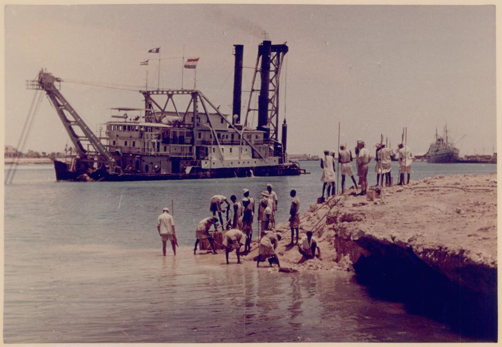
After World War II, the Lake Fithian was acquired by the French dredging and construction conglomerate, Société Française D’Entreprises de Dragages et de Travaux Publics. Founded in 1902, the company boasted a vast portfolio of work in Asia that included a 1,200-mile canal across the Mekong Delta and Hong Kong’s old Kai Tak Airport. The vessel later passed to the Dutch firm Amsterdamse Ballast Maatschapij (ABM, today Ballast Nedam). ABM operated the Lake Fithian on the Suez Canal until Egyptian President Nasser nationalized the waterway in 1956—a move that triggered the Suez Crisis and destabilized the Middle East for years. The aging craft was towed down the Red Sea to Aden, and from there to Calcutta for a World Bank project to eliminate shoals on the Hooghly River. For two years, she and a companion vessel—the Queen of Holland—siphoned off river silt to keep navigable Calcutta’s sole connection to the sea. The Hooghly, born in the Himalayas, carried titanic loads of silt from the Ganges Plain to the Bay of Bengal; the river’s shifting shoals were a perennial hazard to all manner of craft. “Some million tons of shipping must find their way to and from Calcutta each twelvemonth,” wrote Rudyard Kipling in An Unqualified Pilot; and “unless the Hugli were watched as closely as his keeper watches an elephant, there is a fear that it might silt up, as it has silted up round the old Dutch and Portuguese ports twenty and thirty miles behind Calcutta.”
By fall, 1960, the vessels were working the Noorpur Reach below Falta Point, a run of river known for treacherous currents. At about eight o’clock on the evening of November 18, the Lake Fithian’s captain cut the engine to make a repair; most of the crew went below for dinner or a game of cards. Some 30 minutes late, the port (left) cable winch failed, causing the vessel to swing starboard with the river current. At just that moment a massive tidal bore reached the aged vessel, striking it broadside. As it leaned, the massive boilers broke free of their mounts and fell. their tremendous weight capsized the Lake Fithian within minutes. Seventeen men—five Indians and 12 Dutch nationals —were trapped in the hold and drowned. The fast-flowing Hooghly quickly covered its deed, scouring a deep depression around the sunken vessel and burying it in silt. The wreck was not recovered for months; the body of one of the Dutch seamen was never found. Rumors spread that ABM deliberately positioned the age, heavily insured Lake Fithian on the most dangerous part of the river, while the company’s prized new Queen of Holland was kept out of danger.[4]
At the playgrounds along Gerritsen Avenue today, a misplayed ball will tumble off court and into the sand, coming to rest alongside on sand and muscle-shell fragments sucked up from the deep a lifetime ago, by a vessel that ended its days 8,000 miles and a world away from its Great Lakes cradle.
NOTES
[1] “Kids Swarm to Marine Park Dredge Scene,” Brooklyn Daily Eagle (23 July, 1931).
[2] “Marine Park Made Paradise for Snipe,” Brooklyn Daily Eagle (3 August, 1931). Snipe are notoriously difficult to shoot, hence the origin of “sniper” to describe a marksman of particular skill.
[3] Tenth Annual Report of the United States Shipping Board (Washington: GPO, 1926), 90; “Ramp met ‘Lake Fithian is niet helemaal een geheim…” De Waarheid (17 December, 1960).
[4] http://www.zero-meridean.nl/c_calcutta_181160.html
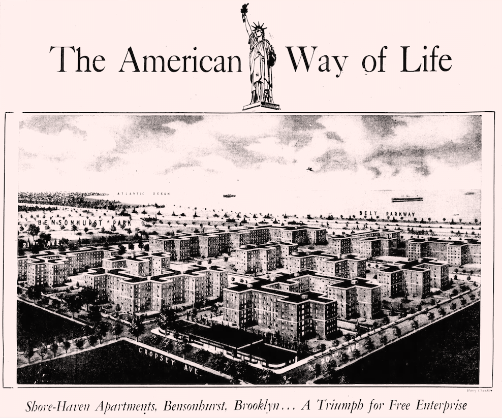
Fred C. Trump, Donald Trump’s father, was the biggest residential developer in Brooklyn in the 1930s and 1940s, and one of the most prolific in the United States. He erected thousands of modest row houses and apartment buildings in East Flatbush, Marine Park, Brighton Beach, Coney Island, Gravesend and Bath Beach. His homes were well-built and affordable, largely due to economies of scale. Known as the Henry Ford of housing, Trump applied techniques of mass production to residential construction long before William Levitt and Levittown. His largest projects were always located near rapid transit (a 1941 bus strike convinced him never to rely on surface transit). Trump’s early homes were exquisitely-scaled “brick bungalows” designed in the popular Tudor style, while those built after World War II were exclusively Modernist. His most trusted architects were outsiders to the mainstream profession–“Miami Modernist” Morris Lapidus and Irving Seelig and his partner Harry Finkelstein.
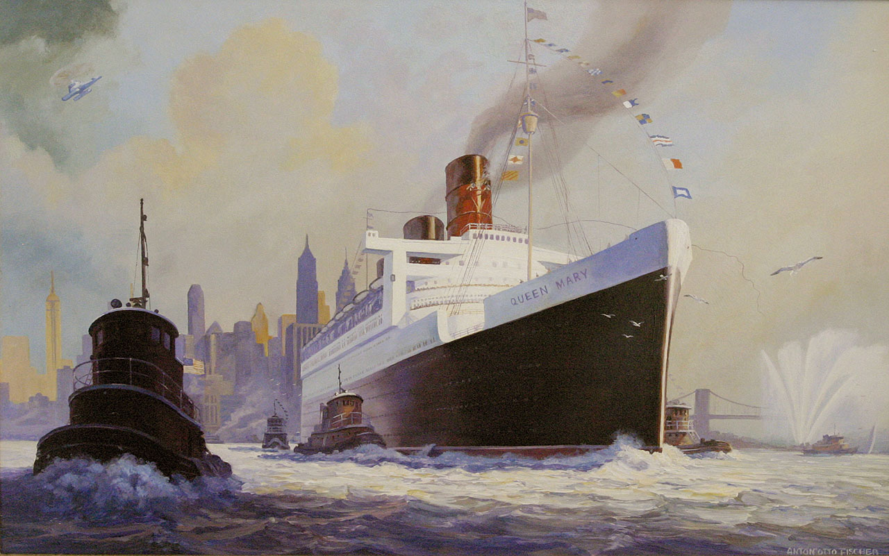
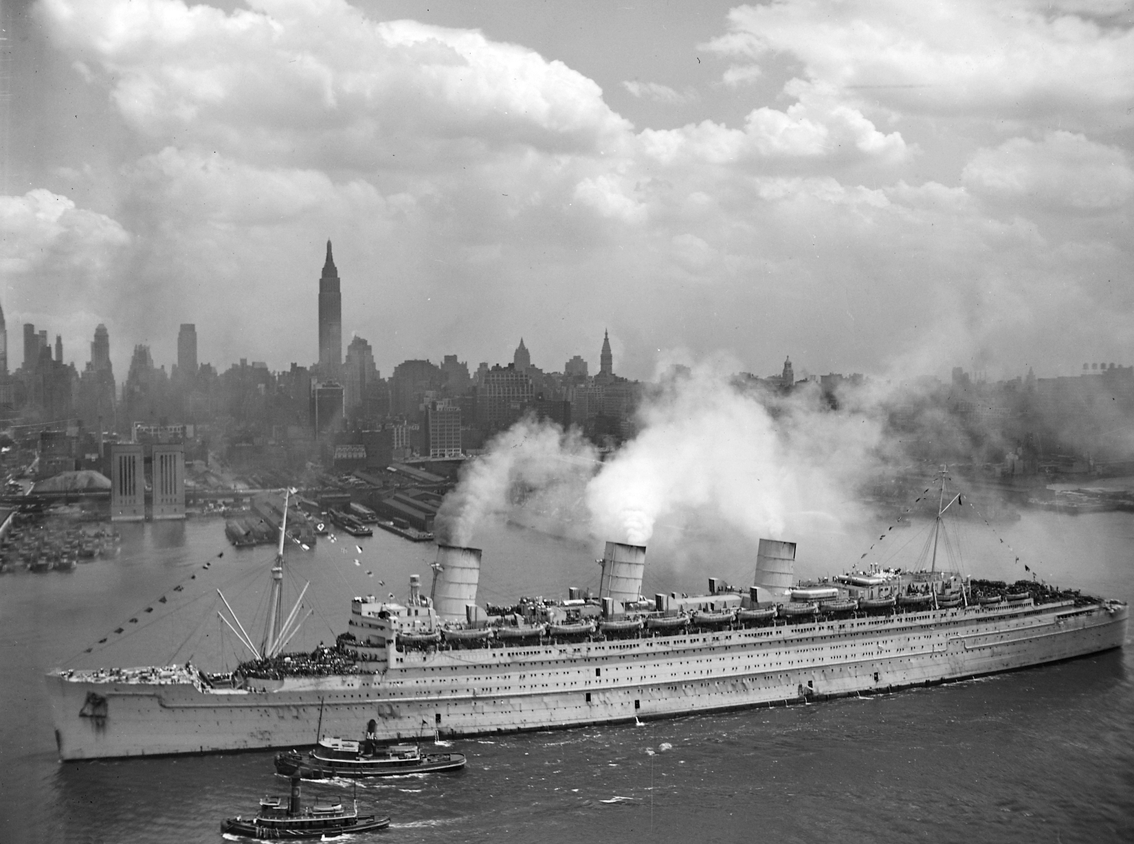
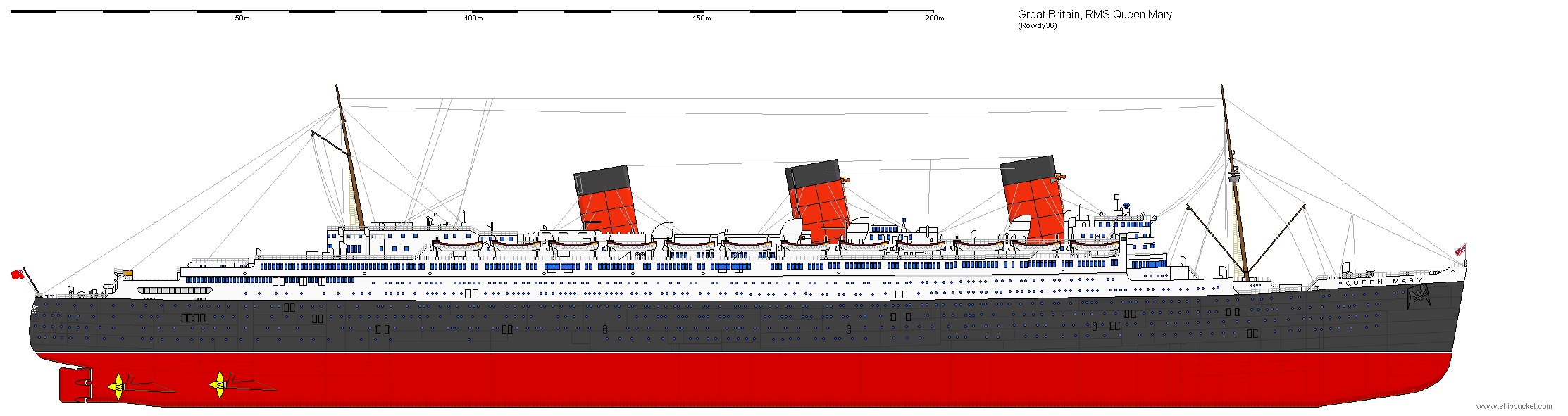
The RMS Queen Mary made her last transatlantic voyage in September, 1967. By then the ship had schlepped two million passengers nearly four million miles back and forth across the North Atlantic. As long as the Chrysler Building is tall and once the fastest ocean liner in the world, the fabled ship would become—what else?—a floating high school in Brooklyn—the HS Queen Mary. That, at least, was what the still-fresh administration of Mayor John V. Lindsay envisioned for the boat. Lindsay knew ships: he had rushed his studies at Yale to join the Navy at the start of World War II, serving as an officer on the destroyer USS Swanson.
In the spring of 1967, the inimitably-named chairman of the Cunard Steamship Company, Sir Basil Smallpiece, announced that the Queen Mary would be auctioned with a starting bid pegged to its scrap value of $1.82 million. In our present age of dwindling resources and lean economies, its seems incredibly wasteful to junk a ship barely 30 years old—half the age of our still-working B-52 bombers. But the ship was reportedly losing $2 million a year for Cunard, as the nascent airline industry cut deeply into the transatlantic travel trade.
Gotham had plenty of competition for the craft. Some 300 bids for the Queen Mary were received from around the world, along with hundreds more suggestions for repurposing the ship. An Australian investor proposed converting the vessel for the emergency transport of immigrants. An Atlanta, Georgia businessman sought to make the ship a traveling trade fair—a kind of mercantile Noah’s Ark upon which would be stowed “everything that’s manufactured in the U.S., if we can get it aboard.” By the end of July, Cunard had trimmed the list of prospective bidders down to 18. New York was still in the running.
However unorthodox a means of procuring a new city school, the idea was not as nutty as it seems. Converting the vessel into a “general comprehensive high school”—for 3,000 students from Williamsburg and Bedford Stuyvesant—was estimated to cost $3 million and take about 18 months. A conventional high school would require $10 million and at least four years to construct, assuming a suitable city-owned site could be found.
The New York Times called the floating school “Lindsay’s Ark,” praising plans for this “almost instant school.” Admitting there was “an ocean of difference between a luxury liner plowing the seas and a high school in Brooklyn,” turning the Queen Mary into a ship of learning was just the imaginative stroke needed to awaken “a far too conventional city and school bureaucracy.” “The tradition-bound planning of obsolete schoolhouses for the nation’s cities,” it opined, “must be replaced by functional and forward-looking buildings”—retrofitted ocean liners included.
But it was not to be. New York was outbid by the City of Long Beach, California, which wanted the ship for a maritime museum and hotel. Instead of deadheading an empty ship to Long Beach, Cunard sent it on a last-fling cruise—with 1,200 passengers “full equally of gaiety and champagne and nostalgia”—to the Canary Islands, Rio de Janeiro, around Cape Horn to Valparaiso and Lima and Acapulco and on up the California coast to San Pedro Bay. The last voyage, ironically, was hugely profitable.
The Queen Mary has been in Long Beach for nearly 50 years now, resting in an artificial lagoon at the mouth of the Los Angeles river, idled far longer than it cruised the high seas.
I was cleaning the workshop this weekend and came upon these copper ten-penny nails, patinated to a lovely shade of green. We don’t generally expect history to dwell in something as ordinary as a nail, but these have a tale to tell. They were salvaged by my grandfather, who had a small grocery store at 96 Hudson Avenue in the 1930s, across from the west wall of the Brooklyn Navy Yard. He provisioned the place several times a week by wheeling a large cart to nearby Wallabout Market, where truck farmers from rural Brooklyn, Queens and Long Island hawked their produce (incidentally, the term “truck farm” derives from the French troque, to barter or trade, and has nothing to do with motor vehicles). Offended by waste in any form, my grandfather would gather the broken crates scattered and left behind in the fog of trade. Back home, he would pry out the nails that held the crates together, tapping and hammering each one straight and bundling them in little butcher-paper packets tied with string.

Wallabout Market occupied a narrow 50-acre site just above Flushing Avenue, between Wallabout Bay and the old Naval Hospital. It plugged into the city grid via Washington Avenue, which extended north into Williamsburg and south to Prospect-Lefferts Gardens, where it merged with Flatbush Avenue. The market’s origins date back to the 1880s, when residents of downtown Brooklyn began voicing opposition to the farm wagons that traditionally parked along lower Fulton and nearby streets to sell their goods. In September, 1884, city hall passed an ordinance banning such wagons from stopping along any thoroughfare other than Washington Avenue at Wallabout Bay. There, reported the Brooklyn Eagle, the city promised “a warm welcome from the people, a well lighted street, with suitable police protection, together with the earnest endeavor of the authorities to provide . . . a market place in some degree worthy of the magnitude of their mutual interests.” To facilitate trade in the interim, a series of wooden shacks and sheds were erected.

It took a full decade for the city to make good on its promise. In 1894, Brooklyn’s new Commissioner of City Works, Alfred T. White, took up the market cause, making Wallabout his pet project. White was a progressive visionary and housing reformer who helped found the Brooklyn Botanic Garden, donated land for Marine Park and created—in the Riverside Buildings on Columbia Place—worker housing so exceptional that Jacob Riis called them “a big village of contented people.” For the Wallabout project, White hired William Bunker Tubby, an Iowan who had studied architecture at Brooklyn Polytechnic Institute (today’s NYU Tandon School of Engineering). Tubby was a skilled historicist with a solid list of institutional and residential commissions under his belt—including several buildings for Pratt Institute. He chose the Flemish Revival style for Wallabout Market, a rare bird in New York City, and set his buildings in functional rows about a plaza called Farmer’s Square. Anchored by a soaring clocktower, Tubby’s plan was a masterpiece of civic urbanism—an Old-World market square straight out of the Hanseatic League. By the 1920s, Wallabout was one of the busiest produce markets in the world, the 1939 WPA Guide to New York describing it as “a solid mass of vehicles, crates, and barrels, and truck drivers, jobbers, and farmers.”

The loss of Wallabout Market was a tragic one for both cityscape and economy of north Brooklyn. Unlike so many borough landmarks, it was a victim not of urban renewal but war. As the world descended into armed conflict in the late 1930s, shipbuilding at the New York Naval Shipyard (as the Brooklyn Navy Yard was officially known) kicked into overdrive. Space was needed, and the market lay straight in the path of expansion. Tubby’s tower fell to the wrecking ball in the spring of 1941. More than 700 farmers, produce dealers, wholesale grocers and “butter-and-eggs men” were affected by the market’s closure. The expanded Navy Yard became the busiest shipyard in America, churning out an astonishing 17 vessels between 1940 and 1945 (including five aircraft carriers and three of the largest battleships ever built—the North Carolina, Iowa and Missouri.

War or not, Brooklynites still needed their vegetables, and so a new produce market had to be built. Sites were considered on Maspeth Avenue in Queens, at Flushing and Cypress Avenues in Bushwick, along Johnson Avenue at the head of Newtown Creek in East Williamsburg, on Linden Boulevard in East New York—where NYCHA’s Linden Houses are today. Eventually the city settled on a still-rural parcel at Foster Avenue and East 83rd Street in Canarsie for its new Brooklyn Terminal Market.
Demolition of Wallabout Market was already well underway when a farewell party was held on June 14, 1941. The event was presided over by Navy Yard Commandant Harold V. McKittrick and New York City Commissioner of Public Markets, William F. Morgan, Jr. Taps were played by a Navy bugler, speeches were made. McKittrick apologized to the Wallabout Market Merchants Association for the “patriotic inconvenience” he caused them. Afterward a “motor cavalcade” of some 500 cars and trucks set out across town for Brooklyn Terminal Market, a symbolic gesture of linkage between past and present, old and new.
Built in a rush and on a tight budget, the new Brooklyn Terminal Market lacked even a trace of old market’s urban-architectural splendor. It is still operating today as a market cooperative, well off the radar of gentrificant twee, self-described as “Brooklyn’s Best-Kept Secret.”


The United Nations came to Manhattan by way of Queens, and only after sites for its permanent world headquarters were considered as far as San Francisco and the Black Hills of South Dakota. Those shortlisted, however, were all in the Northeast—Philadelphia, Boston, Fairfield County in Connecticut, and “Kykuit,” the Rockefeller family estate near Tarrytown. New York City entered the race in late 1945, when Mayor William O’Dwyer assembled a blue-ribbon commission—the Mayor’s Committee on Plan and Scope—to advance the former World’s Fair grounds in Flushing as the best place for the world peacekeeping body. Robert Moses, chair of the Mayor’s Committee and driving force behind the Queens proposal, had already presided over the miraculous transformation of the Flushing ash heaps into the World of Tomorrow; making the old dumping ground the UN’s permanent world headquarters would be a sweet second act. The board members all agreed, and a mighty lot they were—Nelson A. Rockefeller, Arthur Hays Sulzberger of the New York Times, IBM chief Thomas J. Watson, Frederick H. Ecker of Metropolitan Life, political kingmaker and Postal Service boss James A. Farley, the man who helped put FDR in the White House.
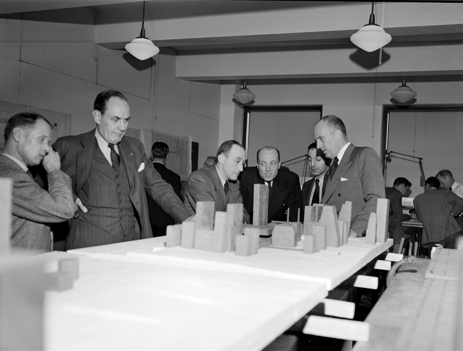
In an October, 1946 New York Times essay, Moses pronounced New York “the natural and proper permanent home for the United Nations,” with Flushing Meadow Park affording “the acreage and opportunities to build an entirely new, independent, self-contained United Nations city on virgin soil.” The site was ideal in many respects—green and spacious, well-served by new infrastructure, a short drive from Manhattan and only minutes from the city’s main airport at the time (La Guardia Field). Using an approach that worked well in planning the Fair, Moses appointed a Board of Design to produce a vision of what the UN Flushing complex might look like. It included Louis Skidmore of SOM; Wallace K. Harrison, designer of the Trylon and Perisphere and one of the architects of Rockefeller Center; and Aymar Embury II, a Moses favorite who created the fair’s New York City Pavilion. Chairing the board was another Moses man, Gilmore D. Clarke. Clarke and his partner Michael Rapuano had planned both the 1939 Fair grounds and subsequent Flushing Meadow Park. No one knew the vast site better.
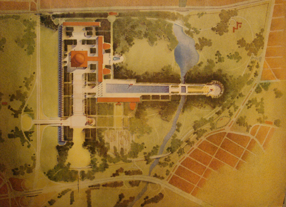
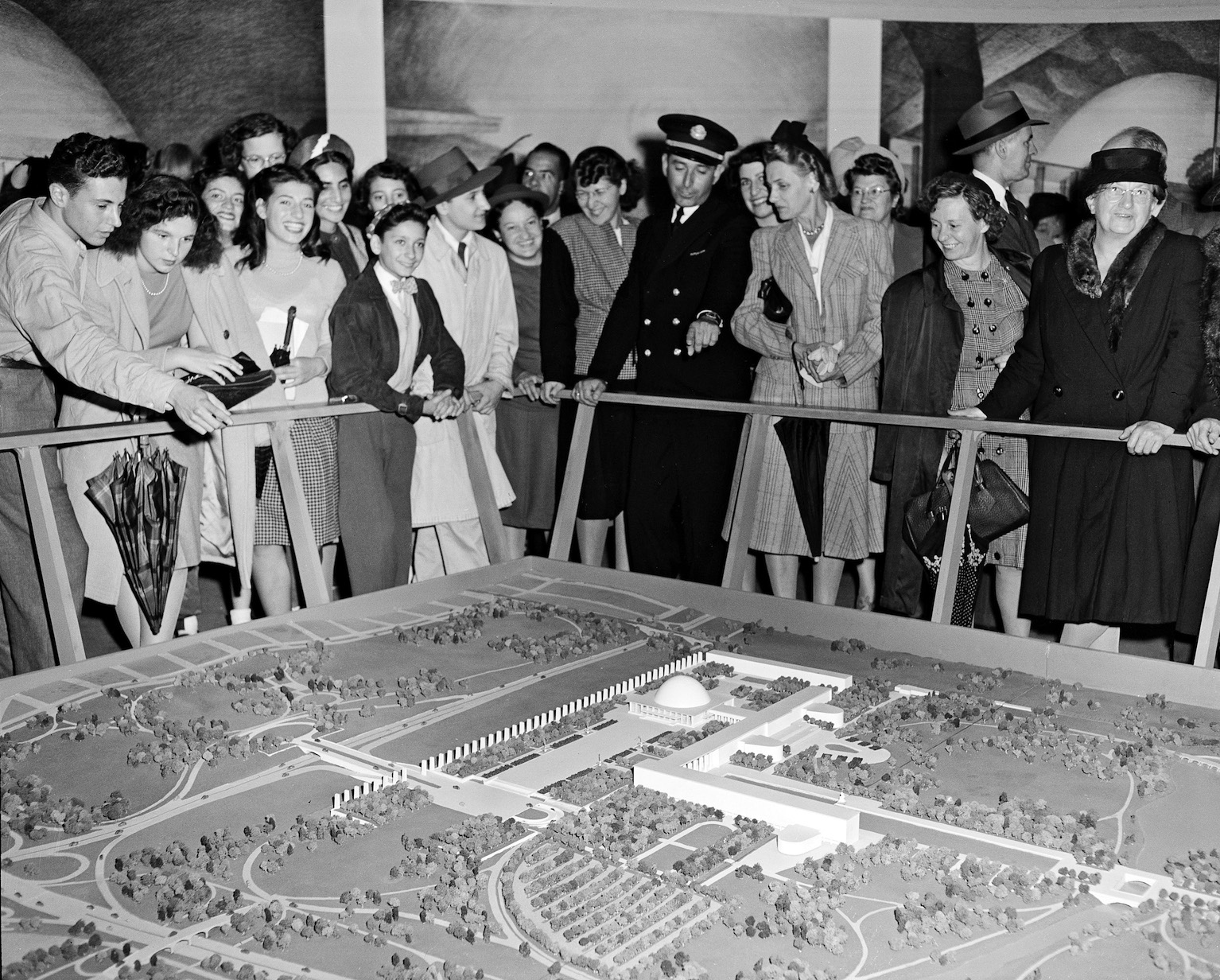
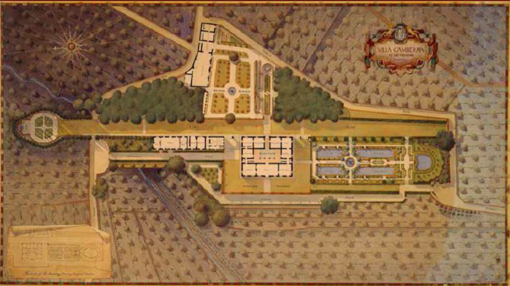
The Mayor’s Committee presented its final report to UN Secretary General Trygve Lie in September, 1946. It was an extraordinary piece of work, with breathtaking perspective sketches by Hugh Ferris and a glorious master plan by Rapuano—a last, late example of the luminous watercolor-wash rendering style developed at the École des Beaux-arts and popularized in the City Beautiful era. The roots of the plan reach back even further. A 1927 recipient of the Rome Prize in Landscape Architecture, Rapuano spent several years studying Italian villas and piazze. His use of an extended axis to organize the UN buildings is reminiscent of a Renaissance space he knew well–the Villa Gamberaia at Settignano, in the countryside near Florence. Rapuano’s mentor at Cornell, Edward G. Lawson, prepared the first measured drawings of the villa while himself a fellow at the American Academy in Rome (for more on Lawson see my 2012 article in Landscape Architecture Magazine, available here).
However impressive, the proposal failed to sway the UN’s Headquarters Commission, which balked at the enormous cost for the sprawling campus—some $65 million. A newly arrived French delegate to the Commission, Le Corbusier, dismissed Flushing as too suburban for his tastes. There were rumors, perhaps apocryphal, that delegates themselves dreaded being marooned in outerborough Queens, so far from Manhattan nightlife. Thus Moses was handed one of his rare defeats, even as the UN General Assembly voted to accept his offer to use, rent-free, a refurbished NYC Pavilion as temporary quarters.
Of course, both the city and Moses prevailed in the end, when William Zeckendorf, Sr. suddenly made available a 17-acre patchwork of parcels on the East River he had planned to develop into a larger version of Rockefeller Center (Wallace Harrison was to design it). Harrison and Nelson Rockefeller convinced Nelson’s father, John D. Rockefeller, Jr., to purchase and gift the Zeckendorf land to the city for the UN complex. As planning of the East River complex moved forward, Moses made sure his trusted designers were at the center of the effort. Most scholarship on the United Nations complex has focused on the Board of Design Consultants, which included a number of internationally prominent architects—Le Corbusier, Oscar Niemeyer, Sven Markelius and China’s brilliant, tragic Liang Sicheng.
But equally influential, if not more so, were Harrison and the so-called Associate Architects and Engineers—”professionals who knew the city,” recalled George Dudley in A Workshop for Peace (1994), who “had the confidence of conservative and ‘modern’ architects, and whose firms could also make personnel available.” Moses and Harrison handpicked three architects to head this team—Clarke of Clarke and Rapuano; Skidmore of SOM; and Ralph T. Walker of Voorhees Walker Foley and Smith. It was immediately after meeting with Moses on in January, 1947 that the UN Secretary General appointed the trio as “associates for the planning of the United Nations Headquarters.” Only weeks later did member nations began forwarding their nominations to the high-profile Board of Design Consultants, and not until February 12 that its first members were approved. Thus the Moses’ men had a solid month’s lead over the Board of Design. Though this latter group—and especially Le Corbusier—would dominate media coverage on the UN project, it was the former, beholden really only to Moses and the Mayor, that held virtual veto authority over any fancy schemes the elite Board came up with. In the end, it was Clarke and Rapuano who quietly determined the final site and landscape plans for the headquarters complex and streets around it.
Though it lacks Manhattan’s cache, Flushing would have been a better place for the United Nations in the long run. The Flushing complex would have been just minutes from JFK, with plenty of free parking for all those diplomat-tagged luxury sedans that collect tickets like leaves in an autumn gutter (UN diplomats owe the city some $16 million in unpaid parking tickets). Big UN powwows could take place without costly, congestion-making police escorts and other VIP tie-ups of tiny, crowded Manhattan. And as Manhattan slowly morphs into an isle of the super-rich, it is the oft-scorned outer borough that may well be a better representative of the world in all its richness and color today. With nearly 140 languages spoken on its streets, Queens is the most ethnically diverse place in America and possibly planet Earth.