
Problem:
Roughly 30% of the world’s total freshwater exists as groundwater. These extensive underground reservoirs are providing a dependable source of water as regions become water stressed due to increasing human demands and / or increasing droughts. However groundwater is relatively slow to recharge and pumping water from wells often occurs faster than the aquifers can be replenished through natural rainfall and snowmelt. The water table drops lower and lower and the world’s aquifers are becoming seriously depleted in many regions. Although this process seems invisible, groundwater is an integral component of most aboveground ecosystems. For example, Winter et al. (1997) calculated that ~54% of all the flow in U.S. streams is derived from groundwater. Groundwater overdraft is causing serious impacts to aboveground, surface communities, with drying of streams and wetlands along with wells and drying of soils beyond their ability to support crops, trees, and other vegetation. It is critical that we understand the linkages between groundwater processes and ecosystems in order to develop appropriate management strategies.
Groundwater Investigations:
The Sustainable Water Lab has been working on various aspects of groundwater-surface ecosystem interactions using seepage meters and piezometer networks in: coastal plain ponds, shorelines of a large inland lake, ponds of the Adirondack Mountains, and in the barrier-island dune and swale system of coastal Virginia. From this work, we have documented that:
- Many lakes and ponds are sustained, in part, by invisible subsurface flows of groundwater from the surrounding watershed. These inputs influence the shoreline plants through their impacts on the chemistry of sediment porewaters that bathe the plant roots.
- Groundwater flowing through shorelines is highly dynamic throughout the year. In northeastern lakes, it peaks in late winter/ early spring along with snowmelt, then declines during the summer, with flow rates dropping to zero or even reversing direction, such that lake water begins to recharge the groundwaters under the lake.
- In coastal barrier islands, the salinity of groundwater located just centimeters below the soil surface is influenced by storm-driven overwash which inundates the swales behind the primary duneline. These overwash events may last only a few hours and reoccur once a year or less frequently, but the salty conditions continue to interact with plant roots for months to years, contributing to the highly diverse mosaic of plant communities across these barrier islands.
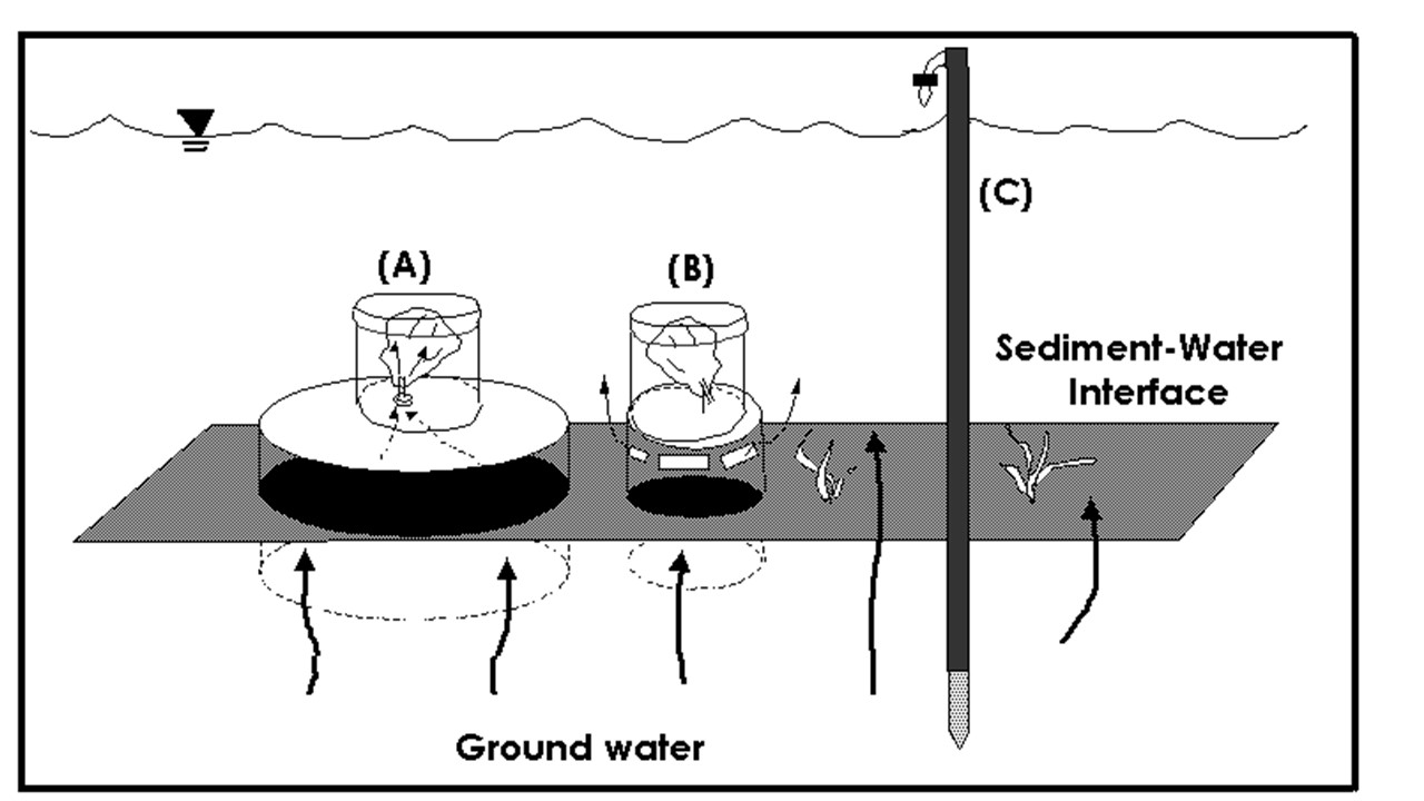

A seepage meter (A) and it’s paired control meter (B) , both shown with their lids which reduce wave affects, were used to measure groundwater discharge rates around the shoreline of Oneida Lake, NY. (C) is the associated porewater sampler.
Researching Solutions:
Schneider, R.L., T.L. Negley, and C.Wafer. 2005. Factors influencing groundwater seepage in a large, mesotrophic lake in New York. Journal of Hydrology 310 (1-4): 1-16. http://dx.doi.org/10.1016/j.jhydrol.2004.09.020
Sebestyen, S.D. and R.L. Schneider. 2001. Dynamic temporal patterns of nearshore seepage flux in a headwater Adirondack lake. Journal of Hydrology 247 (3-4): 137-150. http://dx.doi.org/10.1016/S0022-1694(01)00377-8
Sebestyen, S.D. and R.L. Schneider. 2004. Seepage patterns, pore water, and aquatic plants: hydrological and biogeochemical relationships in lakes. Biogeochemistry 68 (3): 383-409. DOI: 10.1023/B:BIOG.0000031036.32100.8f
Schneider, R.L. 1984. The relationship of infrequent oceanic flooding to groundwater salinity, topography, and coastal vegetation. M.S. Thesis. Dept. Environmental Sciences, University of Virginia, Charlottesville.78 pp.
schematic by J. Negley photo by R. Schneider