Bobcat Density Estimation
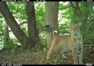 In 1977, the bobcat (Lynx rufus) was listed in Appendix II of CITES due to its similar appearance to the endangered Iberian lynx (Lynx pardinus), and thus its trade is currently managed by the federal government. This listing also granted the New York State Department of Environmental Conservation (NYSDEC) the authority to implement bobcat harvest seasons to control where and when harvest is allowed in New York. To manage bobcats for all stakeholders, NYSDEC must have a robust estimate of bobcat abundance in the state. Traditionally, these estimates have been based off harvest indices, which can susceptible to bias. Spatially explicit models based on resighting individual bobcats offers a more robust alternative to harvest indices.
Unlike bobcats in other parts of their range, bobcats in New York are not as easily individually identifiable through camera trapping alone. Therefore, we will estimate the density of bobcats across New York State using a Spatial-Mark-Resight (SMR) study design. To do this, we will collect occasion histories by deploying identifying ear tags on a subset of bobcats in the state and conducting multiple seasons of camera trapping. We will also deploy GPS collars on a subset of bobcats to collect movement behavior information for input in our SMR model. This information will yield robust estimates of bobcat density which will directly contribute to the management and conservation of bobcats in New York State.
Collaborators: New York State Department of Environmental Conservation
Monitoring Bat Population Trends

White-nose syndrome, caused by the fungus Pseudogymnoascus destructans (Pd), has led to dramatic declines in bat populations across North America. First detected in New York’s Howe’s Cave, this disease disrupts hibernation, causing bats to awaken too frequently, leading to fatal dehydration and energy loss. Since its discovery, white-nose syndrome has spread across much of the continent, contributing to population declines exceeding 90% in some species. To date, 12 of the 47 bat species in the U.S. and Canada have been directly affected, with the fungus detected on an additional six species. In response, many states have launched monitoring programs to track how bat populations are changing. Our research leverages mobile acoustic data—bat calls recorded from vehicles traveling standardized routes—collected by states across the Northeast. This project has two main goals: 1) Conduct simulation studies to identify how many calls must be verified and how many surveys are needed to accurately estimate population trends; 2) Analyze long-term acoustic datasets from states with sufficient sampling to estimate trends in abundance of bat populations. By combining statistical simulation with applied analysis, our work supports science-based recommendations for acoustic survey design and validation protocols—ensuring that existing monitoring efforts yield reliable insights into the future of North American bat populations.
Snapshot NY: Leveraging community science for statewide mammal monitoring

Snapshot NY is a collaborative, grid-based camera trapping initiative designed to monitor mammal populations across New York State, primarily on public lands. The project is led by Dr. Angela Fuller in partnership with Cornell University, the New York State Department of Environmental Conservation (NYSDEC), and a growing network of volunteers from across New York who are helping to build one of the most comprehensive wildlife datasets in the region.
The goals of Snapshot NY are to:
• Engage citizens scientists across the state in collecting trail camera images of mammals.
• Use collected images to estimate abundance, occupancy, density, and distribution of multiple mammal species in NYS.
• Document statewide mammal biodiversity and detect long-term trends.
• Inform wildlife conservation and management efforts.
To standardize coverage across the state, New York has been divided into over 4,500 grid cells, each available for participants to select. Using motion-activated trail cameras and standardized protocols, volunteers help collect critical data on mammal presence, distribution, and other population metrics across diverse landscapes – from forests and farms to cities and backyards. Volunteers can create an account and select their grid cell through the Snapshot NY website, then use our custom-built Snapshot NY app to deploy their cameras and log camera details directly to our research database. Volunteers are a crucial part of the long-term success of the project. By combining rigorous scientific methods with public participation, Snapshot NY empowers New Yorkers to take an active role in wildlife research and conservation. With the help of volunteers in NYS, we’re building a high-resolution, long-term dataset that helps scientists and decision-makers better understand and manage the state’s rich mammal communities.
For more information visit the Snapshot NY website: www.snapshotny.org
Download the Snapshot NY app on the Google Play Store or Apple store.
Follow us on social media!
Facebook: Snapshot NY
Instagram: ny_snapshot
X: ny_snapshot
TikTok: snapshot.ny
Statewide Abundance of Breeding Birds – New York Breeding Bird Atlas III

This project is part of the Third New York Breeding Bird Atlas (NY BBA), which integrates data-driven research with public engagement to strengthen bird conservation efforts. The Atlas mobilizes thousands of volunteers across New York State to record bird occurrences and breeding behaviors, generating demographic data on breeding species every twenty years, since the first Atlas was conducted in 1985. In addition to this extensive community science effort, more than 4,000 sites were surveyed during the summers of 2023 and 2024 using standardized point count protocols and autonomous recording units (ARUs) to collect robust data across a representative range of habitats and conditions. To overcome the challenges of bird monitoring, we will apply an Integrated Distance Sampling (IDS) framework. This approach combines multiple data sources, that is in our case ARUs, point counts, and detection non-detection data (such as Atlas data), within a unified model that assumes all data arise from the same underlying density process while accounting for differences in detectability among sampling methods. By integrating these complementary datasets, the project will generate estimates of breeding bird abundance and density, along with associated uncertainty, providing a framework for large-scale bird monitoring that informs management and conservation strategies across New York State.