
by Professor Jon Parmenter
Abstract
New York State received nearly one-tenth of the “public land” granted by the 1862 Morrill Act, the income from which was to constitute an endowment for at least one college in the state providing instruction in agriculture and the “mechanic arts.” The subsequent administration of those resources by Ezra Cornell and succeeding Cornell University officials took advantage of minimal federal regulatory oversight at the time to adopt innovative financial mechanisms which yielded nearly one-third of the total Morrill Act land-grant revenues generated by all the states to Cornell University. These arrangements are unique in the history of the Morrill Act, and are considered here in light of their roots in prior dispossessions of Indigenous nations by the United States federal government. Analysis of the parcels of Morrill Act acreage located, entered, and subsequently managed by Mr. Cornell (and later, by Cornell University staff), permits us to identify seven specific treaty surrenders of Indigenous land and/or resources concluded circa 1825-1851 that later generated direct benefits to Cornell University. The compilation of this information, it is hoped, will provide not only a more clear understanding of the relationship between Cornell University’s founding and particular incidences of Indigenous dispossession, but also a basis for future conversations regarding the University’s obligations in this matter.
Accounts of Cornell University’s founding as New York State’s land-grant college under the terms of the Morrill Act of 1862 typically highlight the manner in which its organization and objectives addressed the “cardinal demands of the time”: liberalization of curricula in American higher education, promotion of scientific research, and democratized access to professional training in agriculture and engineering (then known as the “mechanic arts”).[1] Now, thanks to a groundbreaking 2020 study by Robert Lee and Tristan Ahtone, we have a much better appreciation of the degree to which the Morrill Act, and, by extension Cornell University’s subsequent founding, were deeply implicated with another prominent demand in nineteenth century America: that for profits taken from expropriated Indigenous land.[2]
From 1776 to 1900, the United States purchased, appropriated, or conquered approximately two million square miles of Indigenous land – a rate of transfer of two square miles per hour within that period of time.[3] By the Civil War era, the United States relied primarily on federal land policies to accomplish the goal of absorbing Indigenous possessions into the national domain.[4] Lee and Ahtone’s research is a comprehensive assessment of the entire system of land-grant colleges and universities established by the Morrill Act, which provided federal grants of so-called “public land” to each of the states as the basis for an endowment for at least one college providing instruction in agriculture and the “mechanic arts.” The authors contend that violence-backed land surrenders obtained by the United States federal government provided the material basis for the Morrill Act, and trace the benefits that flowed from those acts of Indigenous dispossession to the endowments of the nation’s land-grant colleges and universities.[5] While four substantive studies of Cornell University’s land-grant history have been published since 1894, none has addressed the manner in which the lands from which the University benefited entered the federal “public domain,” or considered the profits that flowed directly to the institution in terms of their origin in prior dispossessions of Indigenous nations.[6]
The aim of this essay is to provide a more detailed explication and analysis of Cornell University’s specific relationship to Indigenous dispossession.[7] It may be considered an initial response to the recent call made by University of British Columbia scholar Sharon Stein to
“work backward from a particular land-grant institution in order to ask about the histories and peoples of the lands on which it sits, as well as the lands it selected and sold to fund itself per the provisions of the Morrill Act.”[8]
This essay: 1) explains how the University’s founder, Ezra Cornell, managed the land resources provided by the Morrill Act; 2) it identifies the location and proprietorship of former Indigenous lands from which the University benefited directly; 3) it assesses the circumstances under which those lands were originally taken by the United States; and 4) tabulates (to the extent that information has been made available to date) the financial benefits that have accrued to the University from Morrill Act land grants over the past 157 years. The compilation of this information, it is hoped, will provide not only a more clear understanding of the relationship between Cornell University’s founding and particular incidences of Indigenous dispossession, but also a basis for future conversations regarding the University’s obligations in this matter.
Ezra Cornell and the Morrill Act Lands
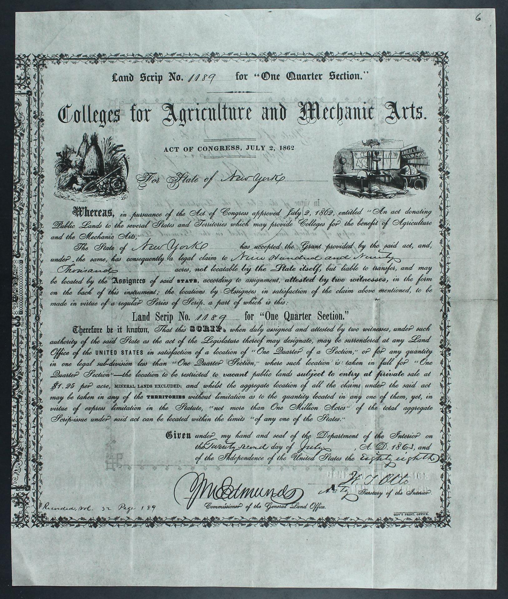
Given the manner in which the Morrill Act linked the distribution of formerly-Indigenous public lands held by the federal government to Congressional representation (30,000 acres were allocated to each state based on the number of representatives and senators seated in Congress), New York’s land-grant college was bound to have an outsized role in the legislation’s subsequent history. Then the most populous state in the Civil War-truncated Union, New York received nearly ten percent of the land allotted by the Morrill Act: 989,920 acres of the 10,929,215 acres that actually passed to the states.[9] Under the terms of the Morrill Act, states with federally-controlled public lands within their boundaries could claim particular tracts and eventually sell them for the benefit of their prospective land-grant college(s). Eastern states with no available public lands at that time, such as New York, received what was referred to as “land scrip” (paper certificates). Each piece of land scrip entitled the bearer to select, locate, and enter (i.e., claim) a quarter-section (160 acres) of unappropriated public land subject to sale by private entry (i.e., land that had gone unsold at a prior public auction) anywhere in the United States. Because the Morrill Act explicitly barred one state from taking direct ownership of land in another state, the expectation at the time was that eastern states would sell their scrip allocations to individuals (“assignees”) and then invest the proceeds in “safe” stocks or bonds yielding a minimum of five percent interest annually. Those revenues would serve as endowment support for at least one college that offered instruction in agriculture and the “mechanic arts.” New York State accepted the Congressional grant provided by the Morrill Act on March 4, 1863. On May 5, 1863 the State Legislature authorized the Comptroller to receive 6,187 pieces of land scrip (160 acres each, totaling 989,920 acres) and sell it for the benefit of what at the time was to be determined as the state’s land-grant college(s).[10]
Into this context stepped then-New York State Assemblyman Ezra Cornell. Recognizing that the scrip, which had a face value of $1.25 per acre, was neither an investment that could return interest nor likely to appreciate in value over time (as actual land would be), Mr. Cornell concluded that the longer New York State held its scrip, the more quickly the most desirable public lands would be located and entered with scrip sold by other states. Reflecting on his management of New York’s land scrip late in life, he wrote:
“Being unwilling to allow this scrip to be sold at the price it would command in the market [approx. $0.50/acre in 1865], I decided to purchase the scrip and locate the lands with my own means and at my own risk for the benefit of the University.”[11]
The story of Mr. Cornell’s decision to ally his own considerable resources with those provided by the Morrill Act to endow the University that now bears his name is recounted elsewhere.[12] Our concern will be with his undeniably skillful administration of New York State’s allocation of Morrill Act land scrip, via what Cornell University historian Carl Becker described in 1943 as “a somewhat more ingenious and complicated manipulation of the provision than a strict interpretation of the act would seem to warrant.”[13] Most non-public land states in the East sold their land scrip quickly after receipt in large blocks to speculators in order to realize immediate returns from the grant. Mr. Cornell understood that had New York thrown its sizeable allocation onto the market at once, the low prices per acre fetched by the scrip in 1864 and 1865 would have been even further diminished. After reaching out to friends and family in Wisconsin, Kansas, and Michigan for information about any large tracts of available public land and the net profits that could be expected from their sale, Cornell concluded that timberlands offered the best chance for high returns and set his sights on the “excellent stands of virgin white pine” on former Ojibwe lands in Wisconsin. He also made an estimate of the amount of land that actual settlers acquired annually from the federal government and calculated that if he (and others) could retain lands located and entered with their so-called “Agricultural College Scrip,” they would eventually obtain higher prices once the desirable government land already on the market had been liquidated.[14]
Locating, Entering, and Flipping Scrip
Once Cornell University obtained its charter from the New York State Legislature on April 27, 1865, Mr. Cornell turned to the task of converting the Morrill Act scrip into revenue for the University. The New York State Comptroller had, by that time already sold 475 pieces of land scrip (representing 76,000 acres), in lots at the discounted prices of $0.83/acre and $0.85/acre, to other buyers, but subsequently halted any further sales of scrip owing to declining market prices.[15] Mr. Cornell described what happened next:
“After the passage of the act chartering Cornell University, finding 5,712 pieces of scrip in the possession of the comptroller, representing 913,920 acres of land, I turned my attention to the question of converting this scrip into the largest sum of money practicable in a reasonable time. My investigation of the subject led to the conviction that the best policy was for me to purchase the scrip of the State, and locate the land and sell the same as opportunity offered, for the interest of the university.”[16]
Fully aware that few actual settlers in 1865 would buy Agricultural College land scrip since most qualified for free land under the terms of the 1862 Homestead Act, Mr. Cornell nevertheless felt confident that the price of good timberland and farmland would eventually rise. Since the Morrill Act barred scrip-receiving states from locating and entering public lands outside their boundaries, Mr. Cornell decided to undertake this effort himself. He moved swiftly, purchasing 100,000 acres of New York land scrip (625 pieces) on November 24, 1865. Approximately half of these pieces of scrip had been located by March, 1866. From this initial purchase twenty-five pieces were eventually located in Kansas, fifty in Minnesota, and the remaining 550 pieces in Wisconsin.[17]
On April 10, 1866, while Mr. Cornell was serving as a State Senator, the New York State Legislature passed “An act to authorize and facilitate the early disposition by the comptroller of the lands or land-scrip donated to this state by the United States.” This law entitled the trustees of Cornell University, or an individual acting in their interests, to purchase the state’s land scrip for the benefit of the institution.[18] Negotiations between Mr. Cornell and State Comptroller Thomas Hillhouse regarding the terms of the former’s purchase of the balance of the State’s land scrip (5,087 pieces, representing 813,920 acres), took place over the summer of 1866, while Cornell oversaw construction of “Building No. 1” (now Morrill Hall) on Ithaca’s East Hill. The final contract, signed on August 4, 1866, laid out the financial specifications: Ezra Cornell agreed to pay the price of $0.30/acre down, and to deposit stocks or bonds for an amount equal to an additional $0.30/acre, taking the price to $0.60/acre, the estimated market value of the scrip at that time. Mr. Cornell also agreed to locate the lands with the purchased scrip in his own name, to pay all the expenses and taxes associated with the location and management of the land, to sell the land within twenty years, and to pay all the net proceeds over and above the expenses and purchase price of $0.60/acre into the Treasury of the State of New York. The amount the State received from Mr. Cornell for the land scrip (i.e., $0.60/acre) was to constitute the College Land Scrip Fund. Any amount realized from the sale of lands over and above $0.60/acre, less expenses, was to constitute a separate fund known as the Cornell Endowment Fund, the income of which would be devoted in perpetuity to Cornell University.[19] Crucially, the monies that would flow into to the Cornell Endowment Fund were exempted by State law from the usage restrictions specified in the Morrill Act.[20]
These arrangements are unique in the history of the Morrill Act. In no other case did a wealthy individual purchase a sizeable proportion of a state’s land scrip at a relatively low price (albeit market value at the time), comply with the provisions of the federal legislation at that lower price, while subsequently relying on state enabling legislation to open the door for unrestricted speculative profit-taking. Mr. Cornell certainly recognized at the time what he had accomplished for his University. Writing to his wife Mary Ann on the evening of August 4, 1866, he stated that the “struggle is over at last and I have just mailed 200 pieces of land scrip to Mr. Woodward and have written him that we will start for the west by Tuesday the 14th.”[21] He then went on to make the following prediction:
“I now feel for the first time that the destiny of the Cornell University was fixed, and that its ultimate endowment would be ample for the vast field of labor it embraces; and if properly organized for the development of truth, industry, and frugality it will become a power in the land which will controll and mold the future of this great state, and carry it onward and upward in its industrial development, and support of civil and religious liberty, and its guarenty of equal rights, and equal laws to all men.”[22]
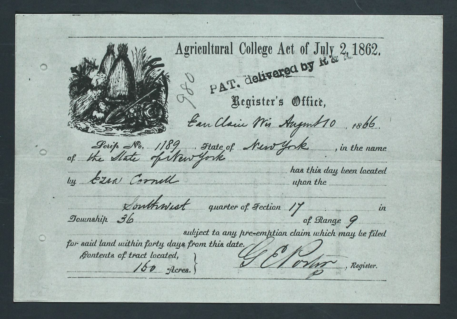
Within three weeks of completing the negotiations for the purchase of the land scrip in Albany, Mr. Cornell had arrived in La Crosse, Wisconsin to meet with a local guide to “Hunt Lands.” On Friday, August 24, 1866, after three days of surveying Wisconsin’s pine timberlands, Mr. Cornell noted in his diary that he had delivered one hundred additional pieces of scrip to Herbert C. Putnam, a clerk in the U.S. Land Office in Chippewa Falls, Wisconsin, to be located in his name. Beyond a cryptic mention of Henry Rowe Schoolcraft’s History and Condition of the Indian Tribes of the United States in a terse diary entry for August 26, 1866, there is no known evidence that Mr. Cornell drew any connection between his undertaking and the prior dispossession of Ojibwe people that made it possible.[23]
From August 4, 1866 to December 31, 1867, Ezra Cornell received 2,700 pieces of land scrip from the Comptroller of New York State, representing 432,000 acres of land. Adding that to the 675 pieces he had purchased in 1865 yields a total of 3,375 pieces of scrip, or 532,000 acres of land in total.[24] The disposition of this acreage, nearly all of it located and entered in Wisconsin timberlands, is detailed in Tables 1 and 2. Mr. Cornell incurred substantial expenses in locating and paying taxes on these lands, but remained convinced that if he could hold them long enough, the ultimate windfall to the University would be worthwhile.
Table 1, DISPOSITION OF THE MORRILL ACT LAND SCRIP RECEIVED BY NEW YORK STATE[25]
| Pieces Sold by Comptroller | 2,862 |
| Pieces Sold by Ezra Cornell’s Agent W.A. Woodward | 52 |
| Pieces lost in U.S. Mail | 14 |
| Pieces left on hand after full amount entered (according to limits of Morrill Act) in Wisconsin | 2 |
| Pieces located on behalf of Cornell University on 511,069.53 acres | 3,257 |
| TOTAL pieces received by New York State | 6,187 |
Table 2, LOCATION OF THE LAND SELECTED AND ENTERED BY EZRA CORNELL WITH MORRILL ACT LAND SCRIP[26]
| Location of Land | # of Pieces of Scrip | Acreage |
| Wisconsin | 3,182 | 499,126.33 |
| Minnesota | 50 | 7,968.27 |
| Kansas | 25 | 3,974.93 |
| TOTAL | 3,257 | 511,069.53 |
Writing in 1943, Cornell University historian Paul Wallace Gates alleged that Herbert C. Putnam violated federal land law by leveraging his dual positions as Register and Receiver at the Eau Claire Land Office to secure for Mr. Cornell (via his agent W.A. Woodward) the prime tracts of pine timber Putnam’s own “land hunters” identified prior to applications made for the same lands by competitors. Putnam, according to Gates, simply logged his own applications (paid for by Woodward with Cornell’s scrip) into the record books and withheld those of others until the reports from his timber cruisers arrived. If the reports were unfavorable, the tracts were reopened to entry for others; if they were, they were entered for Ezra Cornell.[27]
During the autumn of 1867 the University’s trustees, eager for cash to help with the University’s immediate operating expenses, began to pressure Mr. Cornell to sell the balance of his unlocated scrip (2,387 pieces, representing 381,920 acres that remained in the hands of the State Comptroller). Additionally, by this time the limitation in the Morrill Act on the location of a maximum of one million acres of Agricultural College scrip in any one state became a factor, as the three states with the greatest promise of rapid returns from timberlands (Michigan, Minnesota, and Wisconsin) had now reached this threshold. This meant that the balance of Cornell’s scrip would have to be located in states further west, complicating the administration of the lands already located and retained. Mr. Cornell, having found the expenses of the land management business far greater than he had estimated, conceded the logic of the argument, and on December 18, 1867, he agreed in principle with the University trustees and State commissioners to the sale of his remaining scrip at a minimum price of $0.75/acre.[28]
Stubbornly, Mr. Cornell still refused to “sacrifice” the scrip to dealers and speculators. He wrote to Cleveland-based land dealer Gleason F. Lewis, who had been actively buying Agricultural College Scrip since July 1866, and persuaded the latter to accept a plan of “concentrating the entire land scrip trade in his business.” Mr. Cornell then proceeded to solicit the cooperation of the governors of all states that had not yet disposed of their scrip in selling off their remaining allocations to Lewis, whom, having cornered the market, could pay higher prices up front and then hold the scrip out of circulation long enough to still turn a profit for himself. Mr. Cornell described this as the advantageous substitution of “orderly marketing for the haphazard dumping of scrip on a glutted market.”[29]
On April 23, 1868, Ezra Cornell sold two lots of his remaining scrip to Lewis: one of 625 pieces (100,000 acres) at $0.90/acre, and another of 1,125 pieces (180,000 acres) at $1/acre. The remaining 637 pieces (101,920 acres) was reserved for a group of buyers in California, but that deal fell through. In the interim, Congress passed a law on July 27, 1868 that placed a cap of three sections (1,920 acres) of Agricultural College Scrip that could be located in any particular township, which represented a belated gesture against the activities of speculators but reduced the value of the scrip. Mr. Cornell traveled to Washington to lobby congressmen in person for the repeal of this legislation, but was unsuccessful. Lewis purchased the remaining 637 pieces of Cornell’s scrip on December 15, 1868, paying $0.86/acre. By engaging in market manipulation, Mr. Cornell sold off the balance of his unlocated scrip (2,387 pieces representing 387,920 acres) for $357,651.20, an average of nearly $0.93/acre. This was nearly $0.18/acre higher than the minimum established by State commissioners in December 1867, and occurred at a time when the scrip was selling on the open market for approximately $0.60/acre.[30]
Assessing Direct Benefits from Indigenous Dispossession
As of January 1869, we know that Mr. Cornell (or his agents) had selected and entered a total of 3,257 pieces of Agricultural College scrip (representing 511,069.53 acres) in three states: twenty-five pieces (3,974.93 acres) in Kansas, fifty pieces (7,968.27 acres) in Minnesota, and the balance of 3,182 pieces (499,126.33 acres) in Wisconsin.[31] We also know that by this time Mr. Cornell had sold 2,387 pieces of unlocated land scrip to Lewis.[32] Given the interest of Lee, Ahtone, and other scholars in assessing the benefits that flowed to land-grant colleges and universities from particular Indigenous dispossessions, we must consider the nature of those benefits. Certainly, in the case of Cornell University, the direct benefits that flowed from former Indigenous lands selected and entered by Mr. Cornell can be traced (and are, below). Yet when Cornell sold the balance of the scrip to Lewis in 1868, the profits made from the sale represented the endpoint of the benefits derived by the University from the scrip. It is difficult then, to associate Cornell University with the direct benefits deriving from specific Indigenous dispossessions outside of Wisconsin, Minnesota, and Kansas. The University undoubtedly benefited from the opportunity Mr. Cornell created to sell his unlocated land scrip to Lewis at a substantial profit, and subsequent purchasers of the scrip were thereby enabled to select and enter public lands that were the result of prior dispossessions. But neither Mr. Cornell nor the University had any control over parcel selections made with the scrip after it was sold, nor did either entity derive any further profit from the scrip subsequent to its sale. In making this point we are not seeking to diminish the larger argument made by Lee, Ahtone, and others regarding the crucial relationship between prior Indigenous dispossessions and the availability of “public land” for distribution by the Morrill Act; rather, we are attempting to clarify the precise relationship between specific Indigenous dispossessions and the subsequent, significant material profits that accrued to Cornell University.[33]
TABLE 3, MORRILL ACT LAND GRANT ACCOUNTING FOR CORNELL UNIVERSITY: COLLEGE LAND SCRIP FUND[34]
| DATE | ACREAGE | DOLLAR VALUE[35] | EXPLANATION |
| May 5, 1863 | 989,920 | Acreage received by New York State under Morrill Act in 6,187 pieces of land scrip[36] | |
| August, 1864 | -76,000 | $64,440 | Proceeds of New York State sales of 475 pieces of land scrip allocated to College Land Scrip Fund (CLSF)[37] |
| November 24, 1865 | -100,000 | $50,000 | Purchase of 625 pieces of Land Scrip by Ezra Cornell (proceeds to CLSF)[38] |
| August 4, 1866 – December 15, 1868 | -813,920 | $488,562 .87 | Income from balance of New York State Land Scrip sold to Ezra Cornell at $0.60/acre, plus proportional revenue from unlocated Land Scrip sold by Ezra Cornell to Gleason Lewis (proceeds to CLSF)[39] |
| 1894 | $85,573.25 | Premium received on sale of securities when CLSF “was converted into the certificate”[40] | |
| $688,576 .12 | Total value of CLSF, from which Cornell University receives a premium of $34,428.81 (5%) per annum from New York State under terms of Morrill Act[41] |
TABLE 4, UNRESTRICTED REVENUES ACCRUED TO CORNELL ENDOWMENT FUND FROM MANAGEMENT OF LAND OBTAINED UNDER MORRILL ACT, 1865-1923[42]
| INCOME | EXPENSES | ||
| Land | $4,542,563.21 | Purchase price of Land Scrip | $309,200 |
| Timber | $2,211,616.59 | Land location, surveying, and examination expenses | $205,171.16 |
| Trespass Fees Collected | $20,063.90 | Taxes | $648,204.05 |
| Hay | $4,268.14 | Interest | $329,039.70 |
| Rent on Farmland | $758.05 | Salaries | $146,219.93 |
| Sale of 52 pieces of Land Scrip by W.A. Woodward | $408.00 | Commission on sales | $22,513.69 |
| Land Unsold as of June 30, 1923 (160 acres valued at $5/acre) | $800.00 | Travel expenses | $7,893.62 |
| TOTAL INCOME | $6,776,209.75 | Postage and stationery | $3,037.41 |
| Legal fees | $30,392.43 | ||
| Miscellaneous, contingent, and unclassified expenses | $26,914.16 | ||
| TOTAL EXPENSES | $1,728,586.15 | ||
| NET INCOME | $5,047,623.60 [43] |
Cornell University’s particular place in Morrill Act-related Indigenous dispossession may be considered exceptional. Paul Wallace Gates described Mr. Cornell’s undertaking as “one of the largest land speculations in American history.”[44] Most of the eastern, scrip-receiving states benefited directly from the Morrill Act in a manner that avoided the direct costs and risks associated with real estate management and speculation by effectively dumping their scrip into a relatively flooded market for a quick return. Why did they do so? The terms of the Morrill Act permitted only the interest upon the proceeds derived from the sale of the scrip to be used by the states for the support of the colleges they were expected to establish. This provided a strong incentive for states to cash out the scrip quickly.[45] Historian Thomas LeDuc further contends that federally-granted public land paper was an unfamiliar commodity in Eastern states during the 1860s. Most states therefore opted to sell it shortly after receipt, even at steep discounts (as low as $0.41/acre) to avoid the unknown administrative burden associated with locating attractive public land to enter and managing that land until a profitable return could be achieved. In doing so, they missed out on the higher returns later achieved by speculators, such as Lewis, many of his customers, and, as we have seen, Ezra Cornell.[46] Mr. Cornell solved the initial problem of administering the scrip by assuming it himself, and also leveraged his political connections in the State of New York to ensure that the large returns eventually realized (primarily from Wisconsin pine timberlands) by the Cornell University Endowment Fund were legally exempted from the regulations otherwise imposed by the Morrill Act on such returns. In the words of Michael L. Whalen of Cornell University’s Division of Planning and Budget:
“the sequential combination of income from Ezra Cornell’s original founding gift, the Western Lands, and the Land Scrip Fund fueled the operation of the University through most of the nineteenth century.”[47]
Mr. Cornell came under public scrutiny for his management of the land scrip on two occasions. A Rochester newspaper editorial in October 1869 launched an attack on his alleged self-interested motives for managing the land scrip, but it turned out to be a politically-motivated hit piece based on false information. Four years later, when Mr. Cornell sought to turn over the management of the lands directly to the University, the New York Legislature appointed an investigative commission that ultimately cleared Mr. Cornell of any charge of acquiring personal gains from the endeavor.[48] In 1890, the United States Supreme Court ruled in Cornell University v. Fiske, a case involving the disposition of Jennie McGraw’s estate, that the Cornell Endowment Fund, as established by Ezra Cornell, did in fact belong to Cornell University as unrestricted funds for use at the discretion of the University’s Trustees.[49]
Much is often made of the manner in which Mr. Cornell’s “pragmatic vision ultimately resulted in a substantial endowment for Cornell that secured its place among the nation’s elite institutions.” Indeed, Cornell’s investment and its subsequent management by the University Trustees’ land committee yielded incredible returns, averaging $9.69/acre, with a high of $82/acre realized in an 1891 sale at the peak of the late nineteenth-century timber boom. When the University finally sold off the last of its timber and land and closed the Land Committee in 1935, a net total of nearly $5.74 million had been realized from New York’s Morrill Act land grant – the vast majority of which (nearly $5.1 million) constituted unrestricted monies allocated to the Cornell Endowment Fund. New York had received nearly one-tenth of the resources granted by the 1862 Morrill Act, but the subsequent administration of the scrip by Mr. Cornell and succeeding University officials meant that nearly one-third of the total Morrill Act land-grant revenues generated by all the states ultimately accrued to Cornell University.[50]
Seven Dispossessions, 1825 – 1851
Writing about American public lands in 1936, Paul Wallace Gates noted that
“[l]ittle attention has been devoted to the Indian lands and yet there is a story involved in their disposition totally at variance with the conventional account of the era of free land.”[51]
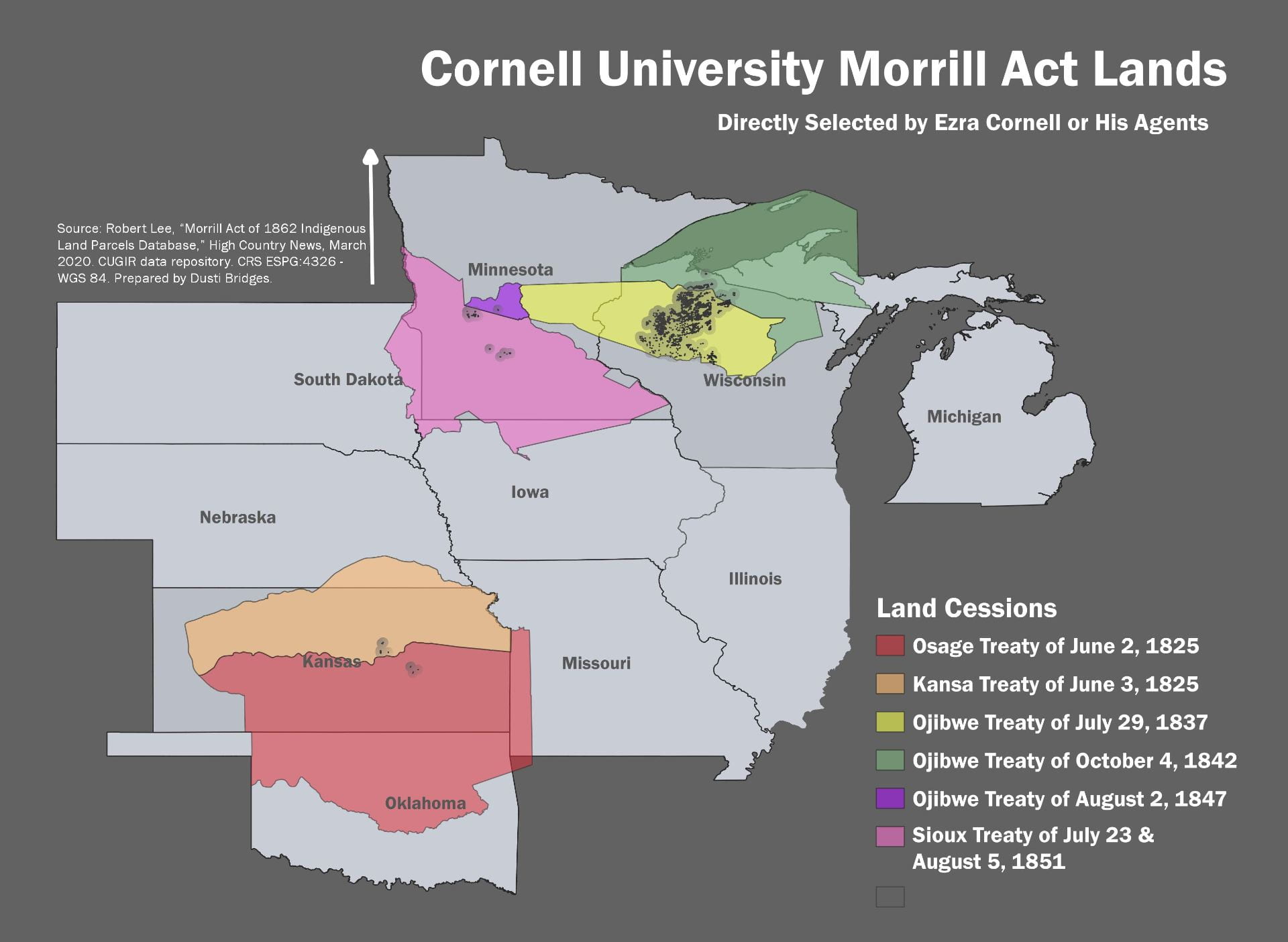
By concentrating our attention on the parcels of Morrill Act acreage located, entered, and subsequently managed by Mr. Cornell and later, by Cornell University staff, we can identify seven specific treaty surrenders of Indigenous land and/or resources that generated direct benefits to Cornell University as a result of the Morrill Act, as detailed in Table 5 and represented on the accompanying map.[52]
TABLE 5, INDIGENOUS SURRENDERS THAT BENEFITED CORNELL UNIVERSITY
| DATE | INDIGENOUS NATION(S) | TREATY REFERENCE | ROYCE[53] CESSION NUMBER(S) |
| June 2, 1825 | Great and Little Osage[54] | 7 Stat. 240[55] | 123[56] |
| June 3, 1825 | Kansa[57] | 7 Stat. 244[58] | 124[59] |
| July 29, 1837 | Chippewa[60] | 7 Stat. 536[61] | 242[62] |
| October 4, 1842 | Chippewa of the Mississippi and Lake Superior[63] | 7 Stat. 591[64] | 261[65] |
| August 2, 1847 | Chippewa of the Mississippi and Lake Superior[66] | 9 Stat. 904[67] | 268[68] |
| July 23, 1851 | Sisseton and Wahpeton Bands of Dakota Sioux[69] | 10 Stat. 949[70] | 289, 414, 440[71] |
| August 5, 1851 | Mdewakanton and Wahpakoota Bands of Dakota Sioux[72] | 10 Stat. 954[73] | 289, 414, 440[74] |
The scholarly literature on official United States foreign relations with Indigenous nations from 1778 to 1871 is vast, and no attempt is made to summarize it here.[75] Brief discussions of these seven treaties, however, may help us to better appreciate the terms under which the lands and resources (from which Cornell University ultimately benefited directly) entered the federal public domain. Each of the seven treaties occurred during an era in which federal policy toward Indigenous nations generally (though not universally) advocated “comprehensive government-sponsored displacement” of Indigenous peoples from their homelands in order to provide desirable territory for agricultural settlement by the growing non-Native population. The history of the so-called Removal Era, according to Syracuse University historical geographer Donald W. Meinig, “is not one that most Americans, then or thereafter, have cared to think about too closely.”[76]
The 1825 Osage and Kansa Treaties
By 1824, with the establishment of the Arkansas Territory (1819) and the State of Missouri (1821) west of the Mississippi River, federal officials began contemplating what then seemed to be the viable limits of western settlement for both the non-Native settler population and the Indigenous nations residing east of the Mississippi River (the latter of whom they sought to relocate). Studying the economies of the Osage, Kansa, Oto, and Omaha nations residing west of the Missouri River, they concluded that a range of territory approximately 200 miles west of the boundaries of the State of Missouri and Arkansas Territory represented the “Western Boundary of Habitable Land” into which eastern Indigenous nations could be relocated and reasonably expected to survive on local resources. In order to clear Missouri and Arkansas Territory for white settlers and also provide space for eastern “emigrant” tribes beyond the Missouri River, federal authorities had to pressure resident nations like the Osage and Kansa into large cessions of their traditional homelands.[77]
In 1803, the Osage Nation controlled much of present-day Missouri, northern Arkansas, southeastern Kansas, and northeastern Oklahoma. Following the Louisiana Purchase, the Osage entered into trade and diplomatic relations with the United States, which deteriorated after an 1808 treaty negotiated by U.S. Indian Agent William Clark (of Lewis and Clark fame). Clark represented the treaty as a peace agreement in which the Osage consented only to allowing American citizens hunting privileges on their territory, but the ratified version of the treaty included a massive land cession of nearly 50,000 square miles – then the largest (fraudulent) land cession by an individual Indigenous nation in American history.[78]
Increasing trespasses into Missouri Territory (which the Osage ostensibly ceded in 1808 but retained treaty-guaranteed hunting rights on surrendered lands) after 1815 by both American settlers and eastern Indigenous nations (Cherokees being the most numerous of the latter) led to escalating friction between both parties of intruders and the Osage. U.S. officials did little to curb intertribal violence between the Osage and Cherokees, but when Osages attacked a party of white hunters trespassing on their lands in 1823, the military moved in. The Army established Fort Osage (later Fort Gibson) in the heart of Osage homelands at the Three Forks of the Arkansas River (in present-day eastern Oklahoma) as a precursor to treaty negotiations. On June 2, 1825, Osage leaders Clermont II and Pawhuska agreed to cede all their remaining lands in the State of Missouri, the Arkansas Territory, and parts of present-day Kansas and Oklahoma) in exchange for a strip of reserved land (fifty miles wide and 125 miles in length, with its southern boundary corresponding to the present border between the states of Kansas and Oklahoma) in what is now southern Kansas. Commissioner of Indian Affairs Thomas L. McKenney reported that the treaty extinguished Osage title to nearly 100,000,000 acres of land. One of the most powerful Indigenous nations in the American midcontinent at the turn of the nineteenth century had thus been dispossessed of nearly all their traditional homelands.[79]
One day after the signing of the Osage treaty, United States authorities concluded a similar agreement with the neighboring Kansa nation. The Kansas, like the Osage, were experiencing problems with settler incursions into their homelands and conflicts with other Indigenous nations over access to game animals. In return for an annuity of $3,500 payable for twenty years, the Kansas surrendered claims to all their land in northwestern Missouri and all in what is now the State of Kansas (except their reservation).[80]
The 1825 treaties with the Osage and Kansa nations played a crucial role in laying the territorial groundwork for the federal government’s ruthless experiment in human geography: relocating eastern Indigenous nations to what was referred to at the time as the “Indian,” or “Western” territory west of the Missouri River. By 1845, the federal government had relocated an estimated 82,000 eastern Indigenous peoples to the former homelands of the Osage, Kansas, and other Indigenous nations.[81] The 1825 treaties also represented critical turning points in the respective histories of the Osage and Kansa nations. Their new reservations exposed them to attacks from better-armed and mounted Plains nations, such as the Comanches, Pawnees, Arapahoes, Kiowas, and Southern Cheyennes.[82] Osage efforts to exercise treaty-reserved rights to hunt on ceded lands led to ongoing friction with emigrant nations and non-Native settlers.[83] The federal government, after endeavoring to impose an “economic revolution” on the Kansas via a state-sponsored transition to plow-based agriculture, failed to fulfill the treaty obligations necessary to accomplish that task.[84] Neither the Osage nor the Kansas found themselves in a position to resist subsequent settler pressures on their 1825 reservations after the United States abandoned the idea of a designated geopolitical territory for Indigenous nations west of the Missouri River in 1854. Once Congress took all the land north of 37˚ latitude between Missouri and the Continental Divide to establish the Kansas and Nebraska territories, the Osage, Kansas, and many other Indigenous nations were removed once more to a new “Indian Territory” in modern Oklahoma.[85]
U.S. Treaties with the Ojibwe, 1837 – 1847
American interest in Ojibwe homelands spanning what is now the Upper Peninsula of Michigan, northern Wisconsin, and eastern Minnesota during and after the 1820s differed from the examples of the Osage and Kansas. Non-Native people desired Ojibwe lands not for their agricultural potential, but rather for access to the vast pine forests and rich deposits of copper and iron located thereon.[86] The treaties signed by the Ojibwe with the United States in 1837 and 1842 are, in the words of one of their leading scholars, “very unusual” in the broader context of American treatymaking with Indigenous nations, insofar as their major purpose was to acquire specific natural resources. Neither treaty made provisions for a specific or restricted homeland for the Ojibwe signatories; instead, they continued to live where they chose in their national territories, ceding only settler access to specified trees and minerals.[87]
Wisconsin Territorial Governor Henry Dodge negotiated the “White Pine Treaty” with over 1,000 Ojibwe representatives at St. Peter’s (now Mendota, MN) in the months of June and July, 1837. During the treaty negotiations, Ojibwe leaders made explicit statements that not only reserved deciduous forests from the terms of the surrender but also insisted on their right to continue hunting, fishing, and gathering food (especially wild rice) in the territory opened to settler access. A Leech Lake Ojibwe headman named La Trappe used a visual aid to explain his people’s position:
‘Of all the country that we grant you we wish to hold onto a tree where we get our living and to reserve the streams where we drink the waters that give us life…This is it (placing an oak sprig upon the table near the map). It is a different kind of tree than the one you wish to get from us.’
Other Ojibwe representatives spelled out their “wish to reserve the privilege of making sugar from the [maple] trees.”[88]
During the negotiations, the Ojibwe also tried to place a sixty-year term on the agreement, but Dodge insisted on a surrender for perpetuity. When the Ojibwe then demanded payment in perpetuity, Dodge imposed a twenty-year annuity payment schedule. Dodge also inserted a qualification into Article 5 of the ratified 1837 treaty, which guaranteed the Ojibwe the privilege of usufruct on ceded lands only “during the pleasure of the President of the United States.” He did not articulate this limitation during the negotiations and contemporary American observers acknowledged the Ojibwe would not have agreed to or even understood its import. Dodge concluded the treaty with a promise to deliver the first annuity payment in 1838, and a warning to the Ojibwe to maintain peace with their Dakota neighbors, stating that any attack on the latter would be felt by the “Great Father” (i.e., the President of the United States).[89]
Ojibwe frustration with the annuity payment provisions in the 1837 Treaty (T. Hartley Crawford, the Commissioner of Indian Affairs authorized annuities to any Ojibwe bands who signed the treaty but Dodge sought to limit them to those who immediately occupied and used the ceded territory) coincided with growing American interest in extending access to the mineral wealth located along the southern shore of Lake Superior to bring about a new Ojibwe treaty in 1842. Crawford devised a scheme to facilitate the future removal of Lake Superior Ojibwe from their homelands in Michigan and Wisconsin, instructing the treaty commissioners to include the Ojibwe of the Mississippi (then largely residing in what is now Minnesota) in the annuity payment schedule as an artificial means of creating a common Ojibwe territory on unceded land west of Lake Superior, thereby establishing a possible destination for the Ojibwe of Lake Superior.[90] The journal account of treaty interpreter Henry Blatchford revealed the extreme concern expressed by the Ojibwe at any talk of removal. Indian Agent Robert Stuart framed the treaty as encompassing only a surrender of mineral rights on the lands in question, and represented the time frame for any consideration of removal in terms of decades, or even generations. He assured the Ojibwe that their rights of use to the lands ceded in 1842 would be identical to those negotiated five years previously, as long as they remained at peace with the United States.[91]
Less than a year after the signing of the 1842 “Copper” Treaty, Alfred Brunson, the U.S. Indian Agent at La Pointe (Wisconsin) wrote to Secretary of War John Canfield Spencer to denounce the terms of the treaty as unjust. Brunson argued that the Ojibwe had been grossly underpaid for access to their acreage. He included statements from Ojibwe leaders who reminded American authorities that while they accepted the presence of Americans digging mines and cutting timber, they still “reserve[d] the Birch bark and cedar for canoes, the Rice and the Sugar tree and the privilege of hunting without being disturbed by the whites.”[92]
On the eve of Wisconsin statehood in 1848, the prospect of removal that the Ojibwe had been assured would be many years away appeared in the form of a new treaty with the United States. By 1847, American officials realized that not only were the lands allocated for a prospective Ojibwe removal destination by the 1842 Treaty (essentially the area north of the St. Louis River between Lake Superior and the Mississippi River) incapable of sustaining an influx of Indigenous population, they also contained vast mineral resources. Given this information, Commissioner of Indian Affairs William Medill wrote instructions for a new Ojibwe treaty that would purchase a different tract of Ojibwe land west of the Mississippi to serve as a destination for relocated Ojibwes (and possibly other Indigenous nations) from Wisconsin.[93]
The 1847 Fond du Lac Treaty reflected the U.S. government’s “misinformed, paternalistic, and manipulative” view of its relations with the Ojibwe and turned out to be “a thorough disaster.” Negotiated by Henry Rice, a Minnesota-based Indian Agent and trader, the treaty exposed the divisions among different Ojibwe bands that previous annuity arrangements had created. The Lake Superior bands resented the terms of the 1842 treaty that required them to share annuities from the cession of their own lands and insisted on a share of annuities from the land surrender asked of the Mississippi bands in 1847. Rice negotiated a division of the annuities that strongly favored the Mississippi bands, and, by extension, his own trading interests in Minnesota. Several Ojibwe bands refused to sell their interest in the land involved in the 1847 cession, and for years afterward Lake Superior Ojibwe headmen complained of the conflicts of interest, collusion, fraud, and improper procedures reflected in Rice’s conduct of the treaty.[94] In 1849, Wisconsin Ojibwe leaders traveled to Washington to deliver a pictographic petition to President James K. Polk. Drawn on the inner bark of a paper birch tree and signed with their respective doodem (clan totems), the lines connecting the hearts and eyes of the figures signified the delegation’s unity of purpose in insisting that the United States honor the terms of the 1837 and 1842 treaties.[95]
![Symbolic Petition of Chippewa Chiefs, Presented at Washington, January 28, 1849, Headed by Oshcabawis [Oshkaabewis] of Monomonecau, Wis. (credit: Wisconsin Historical Society Library [public domain image])](https://cpb-us-e1.wpmucdn.com/blogs.cornell.edu/dist/e/9340/files/2020/09/Image5OjibwePetition.jpg)
The United States finally abandoned efforts to remove the Ojibwe from Wisconsin in 1851, one year after a genocidal [96] attempt to coerce the Ojibwe into removal by manipulating the delivery of treaty-promised annuities to a very late autumn date at a distant location in Minnesota Territory. The resulting “Sandy Lake Tragedy” ended up costing the lives of an estimated 400 Ojibwe, mostly adult men, who died of starvation, exposure, and disease, before the survivors could get home to their lands in Wisconsin.[97] Anishinaabe historian Michael Witgen offers a compelling analysis of how, by the mid-nineteenth century, treaties signed by the Ojibwe transformed the very nature of Indigenous social relations by linking political power to a constricted land base defined by property rights. This change, in Witgen’s view, made it much more difficult for the Ojibwe to “mobilize political power by creating use rights” across an extensive shared land base.[98]
After the post-Civil War influx of non-Native agricultural settlement into northern Wisconsin and Minnesota, the Ojibwe “worked out a symbiotic relationship of mutual support” with their American neighbors, supplying a wide array of food products and handicraft items in exchange for farm produce and manufactured goods.[99] By the turn of the twentieth century, the unilateral imposition of fish and game laws by Midwestern American states increasingly forced the activities of Ojibwe subsistence hunters and gatherers underground. Enforcement of those laws by state game wardens had, by 1950, nearly eliminated Indigenous subsistence activities beyond reservation boundaries. The subsequent legal dispute initiated by the Ojibwe elicited nearly a decade (most of the 1980s) of violent non-Native protests against the notion of contemporary Ojibwe people exercising “peacefully the rights their ancestors had secured” in the treaties of 1837 and 1842, as part of an effort “to preserve their culture and traditions for future generations.”[100]
Two Treaties with the Dakota Sioux, 1851
In 1851 four bands of Dakota Sioux (Mdewakantons, Wahpekutes, Sissetons, and Wahpetons, known collectively as the Santee)[101] residing in Minnesota Territory became early test cases for a new federal Indian policy initiative aimed at concentrating western tribal nations on small reservations distant from both centers of settler population and increasingly busy travel routes to Oregon and California. This shift in emphasis away from outright removals of Indigenous populations came shortly after the transfer in 1849 of responsibility for management of Indian Affairs from the War Department (by then widely criticized for its handling of removal) to the civilian Department of the Interior.[102] Seeking greater efficiency in the regulation and redistribution of lands obtained from Indigenous nations, Indian Bureau officials turned their gaze to the Minnesota Territory. Although officially organized on March 3, 1849, only three percent of its defined area had to date been ceded by resident Indigenous nations to the United States.[103]
Historians of the Santee identify the middle decades of the nineteenth century as witnessing the transition, within a generation, of these nations from self-sufficiency and political autonomy to destitution and economic dependency on the United States. Land surrenders to the United States commenced in 1830, and within a decade white settlers appeared on the borders of Sioux homelands, further straining the region’s already-diminished game populations. Scarcity of animals hunted for food, declining demand for peltry marketed in the fur trade, and escalating prices of trade goods engendered widespread indebtedness among Santee Sioux communities. Poverty weakened the Santees’ bargaining leverage, and after two failed attempts in 1841 and 1849, federal authorities finally succeeded in persuading all four bands to sign treaties in 1851. In these treaties, the Santee surrendered all their land in the Minnesota and Dakota territories (estimated at 25,000,000 acres, encompassing “some of the most valuable agricultural land on the continent”) in exchange for annuity payments and a reservation.[104]
U.S. Commissioner of Indian Affairs Luke Lea, who served as a treaty commissioner at the two Santee treaties, described the difficulty with which the two westernmost bands (Sissetons and Wahpetons) reconciled themselves to the surrender of land at the July 1851 Traverse de Sioux negotiations:
It was soon perceived that although there was a vague and indefinite idea on the part of these people that it was necessary for them to sell at least a portion of their country, in order to secure them against the misery and almost starvation which the diminution in the number of the buffalo and other game for the last few years had inflicted upon them; yet, when they were brought to meet the proposition in a distinct and intelligible form, they appeared to shrink, with undisguised reluctance, from taking a step so important in its results.[105]
To urge the Sissetons and Wahpetons along, Lea threatened to bring an army of 100,000 troops to Minnesota to take their land without compensation. Fellow treaty commissioner Alexander Ramsey, then Minnesota’s Territorial Governor, did his part by withholding food from the Santee gathered at Traverse de Sioux until their attitude toward the surrender changed.[106]
Once the Sissetons and Wahpetons concluded their surrender on July 23, 1851, the Mdewakantons and Wahpekutes were effectively surrounded by United States territory. They agreed to terms with Lea and Ramsey at Mendota (the site of the 1837 treaty with the Ojibwe) on August 5, 1851. The corrosive influence of Henry Rice manifested itself once more in the Santee treaties: of the approximately $3 million paid by the United States for the Santee lands, $305,000 was paid in cash, and the rest paid over time in annuities. Of that $305,000, $240,000 was transferred directly to traders to retire Santee debts. When the treaties reached Washington for ratification, Senate negotiators removed the provision providing for a ten-mile wide and fifty-mile long Santee reservation straddling the Minnesota River, leaving the Santee in limbo with regard to their legal residency for nearly seven years.[107]
In 1858, after signing another treaty that compelled them to surrender nearly half of the land that had been set aside for their reservation seven years previously, the Santee received a reservation along the Upper Minnesota River. Then numbering approximately 6,000 persons, the Santee struggled to come to terms with the aggressive civilization program implemented on the reservation by Indian Agent Joseph R. Brown, who wielded treaty-guaranteed annuity payments as coercive means to bring about compliance with an economic transition to plow agriculture. Those who cut their hair, moved into single-family clapboard homes, and planted crops received annuity payments. Those who refused to comply did not.[108]
By 1862, circumstances on the Santee reservation reflected the compound effects of the federal government’s abject failure to fulfill promises made in the treaties of 1851: the space allocated to the Santees was inadequate, annuity payments were unreliable and inequitably distributed, and the remote location of the reservation caused problems with delivery of treaty-promised foodstuffs that the Santees relied on.[109] In August 1862, the Santees deferred their annual bison hunt to wait on the annuity distribution, which was late. Short on food, and indebted to the point that the Indian Agency’s traders stopped issuing credit, the Santees approached Indian Agent Andrew Myrick for assistance in feeding themselves. Callously, Myrick suggested that they could “eat grass.”[110]
On August 18, 1862, less than six weeks after the signing of the Morrill Act, one hundred Santee warriors (predominantly Mdewakantons and Wahpekutes) entered federal buildings and warehouses on the reservation and began killing traders and government employees. Myrick’s corpse was found with grass stuffed in its mouth. The “Great Sioux Uprising” (or Dakota War) of 1862 subsequently spread to neighboring non-Native settlements in the Minnesota and Dakota territories. Mdewankanton leader Little Crow, a signatory of the August 1851 treaty at Mendota, played an active role in the war. Over 400 American settlers lost their lives before a combination of regular troops from Fort Ridgely and civilian militia brought an end to the conflict with widespread retaliatory attacks on the Santee, irrespective of their culpability in the hostilities in September 1862.[111]
A military commission established in Minnesota after the end of hostilities tried 392 Santee prisoners of war, condemning 303 to death. After reviewing the trial records, President Abraham Lincoln commuted the sentences of all but thirty-eight of the accused, “mostly deemed guilty by association with others who might have killed civilians.” On December 26, 1862, 3,000 Minnesotans gathered at Mankato to observe the hangings of the thirty-eight Santee prisoners of war in what remains to date the largest mass execution in American history.[112]
A number of Santee subsequently fled to Canada. Civilian authorities in Minnesota saw to it that the federal government ejected the Santee permanently from Minnesota; they subsequently negotiated for new reservations in the Dakota Territory. By 1863, the lives of all Santee were, in the words of historian Patricia C. Albers, “orchestrated by the policies of the United States and Canadian governments.”[113]
Flipping the Script: Prospects for Moving Forward
“What’s the point of dredging all this up?” a friend asked me when I told her about this research. “What’s your agenda?” These are fair questions. From the standpoint of a historian the realization that this information has been hiding in plain sight for more than a century and yet never considered in the context of Indigenous dispossession is at once sobering and arresting. Much more importantly, that realization raises the question of whether there are indeed past matters which, when brought fully to light, warrant careful and thoughtful consideration, as well as atonement, in the present. I began the research for this essay with a vague sense that appropriated Indigenous lands contributed somehow to the founding of Cornell University. I hope that what appears above not only clarifies and, to an extent, quantifies that notion, but also encourages a much broader appreciation henceforth that the lands which provided those benefits were in fact the “birthright” of a number of different Indigenous nations.[114] “New occasions,” as J.L. Morrill, President Emeritus of the University of Minnesota stated in his 1962 Centennial Address to the Association of State Universities and Land-Grant Colleges, “teach new duties.”[115]
In 1965, Lawrence Veysey described Cornell University as “the first spectacularly visible fruit of the Morrill Act.”[116] As recently as 2010, then-Provost Kent Fuchs commented to an alumnus of the University on the relationship of Ezra Cornell’s management of the land grant resources to the future success of the institution:
“I continue to be grateful that we have had leaders throughout Cornell’s history who made strategic decisions from which to benefit [sic]. The land grant funds and mission are a major part of our present success as well as our future. I would not want to consider a Cornell that was not a land-grant university or had not wisely used the original land-grant resources. The historical perspective makes me truly appreciative of those that have come before us.”[117]
There is now, I believe, an opportunity before us to extend our appreciation of those who came before us, beginning with those Indigenous nations whose political and economic circumstances changed forever after the seven American treaties discussed above. Cornell University’s own sense of its land-grant mission, as of 2005, argued that a land-grant university should be “expansive, endlessly adaptable, and always relevant.”[118] The current online statement alludes to the University’s “abiding commitment to the liberal arts, to the development and curation of pure knowledge, and to the application of that knowledge to make a lasting, positive difference in the world.” Overcoming what Margaret Nash has described as “genesis amnesia” – the erasure of origins of policies and institutions that works to obscure the social constructions underpinning them – may help Cornell move toward meaningful reconciliation.[119]
It won’t be easy. There is no “one size fits all” solution: each land-grant institution should assess its circumstances, consult with the Indigenous nations affected, and decide on a way to move forward. Mere institutional statements of acknowledgement are now understood to be insufficient and, in Canada, although more common than in the United States, they increasingly manifest as hypocritical.
We cannot content ourselves with simply tugging at the loose threads of prior treaties to catalogue abuses and misdeeds.[120] To do so does violence to their nature as living documents. Prior Federal treaties with Indigenous nations, however corrupt and unfair they may seem to us today, represented not only a means for the federal government to acquire territory from Indigenous nations,[121] but also for Indigenous nations to secure homelands and/or other economic and political claims on the federal government.[122]
Treaties were, fundamentally, contracts that incurred formal obligations on the signing parties.[123] If they once “functioned as instruments of colonialism,” treaties nevertheless provide a model of inter-group negotiations that may, in a revised form, serve as a “means of restoring respectful relations” between settler society institutions and contemporary Indigenous nations.[124] As Heidi Kiiwetinepinesiik Stark and Kekek Jason Stark (both of the Turtle Mountain Ojibwe Nation) point out, localized negotiations and collaborations between Indigenous nations and non-Indigenous entities may serve as a better stage for enacting contemporary Indigenous sovereignty than contentious litigation, which has only produced popular backlash and wildly inconsistent court rulings on Indigenous sovereign authority. Renewing the process of negotiation to build mutually beneficial relationships helps to bring forward the earlier ways of constructing relations manifested in the first (pre-national) treaties – focusing not on rights attained but rather on the responsibilities and duties each party has toward the other to ensure a shared future.[125]
Commenting on the accelerating territorial expansion of the United States after the Civil War, a process in which we now know Cornell University played a substantial if hitherto underappreciated part, Commissioner of Indian Affairs Francis Amasa Walker made the following observation in 1872:
“The freedom of expansion which is working these results is to us of incredible value. To the Indian it is of incalculable cost. Every year’s advance of our frontier takes in a territory as large as some of the kingdoms of Europe. We are richer by hundreds of millions; the Indian is poorer by a large part of the little that he has. This growth is bringing imperial greatness to the nation; to the Indian it brings wretchedness, destitution, beggary. Surely there is an obligation found in considerations like these, requiring us in some way to make good to the original owners of the soil the loss by which we so greatly gain.”[126]
In the spirit of Walker’s comment about obligations to “in some way make good” to the Indigenous nations who surrendered land that yielded great gains to Cornell University, I will close the essay with four questions (in full recognition that others will have many more):
- Do we agree with the 2012 statement of former Ohio State University President E. Gordon Gee that “[t]he land grant university is the social conscience of American higher education”?[127] If so, how do we respond to the information presented above?
- If we accept that land-grant colleges and universities “have a special obligation to the publics that make them possible,” how do we address “original stakeholders” such as the Indigenous nations whose ancestral homelands were distributed by the Morrill Act, and their “special claim to engagement with and benefits from” land-grant institutions?[128]
- Cornell University retains mineral rights to 420,000 acres of land in central and southwestern states. Are mineral rights retained on any of the lands the University received (and subsequently sold) under the Morrill Act? If so, what are the nature of those rights? Will the University provide a full accounting of the cumulative revenues derived from those rights from their acquisition to the present?[129]
- Paul Wallace Gates reported in 1943 that all the most valuable timber on Cornell University-owned land in Wisconsin had been sold by 1893, but from 1893 to 1904 “a small business was done in the sale of second-growth pine, and of spruce, white oak, pulpwood, ties, and poles.”[130] Does this activity represent a violation of the terms of the 1837 and 1842 Ojibwe treaties respecting the species of trees reserved for Indigenous peoples’ use on surrendered lands? What has been the impact of any deforestation incurred by Cornell University on Ojibwe ceded territory in Wisconsin?
 Jon Parmenter is an associate professor of History at Cornell University, and an affiliated faculty member of Cornell’s American Indian and Indigenous Studies Program.
The views expressed in this essay are entirely his own and do not necessarily reflect those of AIISP, the History Department, or any other entity at Cornell University. He can be reached at jwp35@cornell.edu
[1] Carl L. Becker, Cornell University: Founders and the Founding (Ithaca, NY: Cornell University Press, 1943), 21-22 (quote p.22); Lawrence R. Veysey, The Emergence of the American University (1965; Chicago, IL: The University of Chicago Press, 1974), 81-86.
[2] Robert Lee and Tristan Ahtone, “Land Grab Universities: Expropriated Indigenous Land is the Foundation of the Land Grant University System,” High Country News 52.4 (March 30, 2020) https://www.hcn.org/issues/52.4/indigenous-affairs-education-land-grab-universities (accessed September 27, 2020). Lee and Ahtone rightly credit a prior association of the Morrill Act with Indigenous land transfers by Roxanne Dunbar-Ortiz, in her An Indigenous Peoples’ History of the United States (Boston, MA: Beacon Press, 2014), 140-42. Four years earlier, in 2010, Stephen J. Rockwell pointed out that the Morrill Act “rested on the federal government’s ability to sign treaties with, dispossess, and remove Indians from the land.” See his Indian Affairs and the Administrative State in the Nineteenth Century (New York, NY: Cambridge University Press, 2010), 236.
[3] Arthur Spirling, “U.S. Treaty Making with American Indians: Institutional Change and Relative Power, 1784-1911,” American Journal of Political Science 56 (2012): 84.
[4] Paul Frymer, Building an American Empire: The Era of Territorial and Political Expansion (Princeton, NJ: Princeton University Press, 2017), 151.
[5] Lee and Tristan Ahtone, “Land Grab Universities.” The most recent overview of the historiography of the Morrill Act describes the literature to date as “infused with presentist and romantic notions,” and the authors call for greater effort to “bring factual knowledge and critical awareness to the history of the land-grant movement and its many institutions.” See Nathan M. Sorber and Roger L. Geiger, “The Welding of Opposite Views: Land-Grant Historiography at 150 Years,” Higher Education: Handbook of Theory and Research 29 (2014): 385-422 (quotes pp.388, 416).
[6] Waterman Thomas Hewett, “The History of Cornell University in the Twenty-Five Years of Its Existence, 1868-1893” in John H. Selkreg, ed., Landmarks of Tompkins County, New York (Syracuse, NY: D. Mason & Co., 1894), 413-23; Samuel D. Halliday, A History of the Federal Land Grant of July 2, 1862 For the Establishment of Colleges of Agriculture and the Mechanic Arts, with a Full Account of the Land Scrip Allotted to the State of New York and afterward Given to Cornell University [(1905); 2nd ed., Ithaca: Cornell University, 1923]; Paul Wallace Gates, The Wisconsin Pine Lands of Cornell University: A Study in Land Policy and Absentee Ownership (Ithaca: Cornell University Press, 1943); Michael L. Whalen, A Land Grant University [Reprinted from Cornell University 2001-02 Financial Plan (May 2001), Cornell University, 2002]. A noteworthy exception to this trend is an unattributed ca.2016 online ArcGIS story map (accessed September 27, 2020), “The Untold Story Behind the Brick and Ivy: Cornell University, the Morrill Land Grant Act, and Native American Tribal Cessions.”
[7] My colleague Eric Cheyfitz points out that the University has yet to address the questions raised by Lee and Ahtone in his “Cornell University: The Erasure of Memory,” LA Progressive June 7, 2020 (accessed September 27, 2020).
[8] “A Colonial History of the Higher Education Present: Rethinking Land-Grant Institutions through Processes of Accumulation and Relations of Conquest,” Critical Studies in Education 61.2 (2020): 217. For a fascinating pre-Morrill act case study linking proceeds from expropriated Indigenous lands to the University of North Carolina, see Lucas P. Kelley and Garrett W. Wright, “Without profit from stolen Indigenous lands, UNC would have gone broke 100 years ago,” Scalawag Magazine, September 15, 2020 (accessed September 27, 2020).
[9] Morris Bishop, A History of Cornell (Ithaca: Cornell University Press, 1962), 58; Benjamin F. Andrews, The Land Grant of 1862 and the Land-Grant Colleges, United States Department of the Interior, Bureau of Education Bulletin No.13 (Washington, D.C.: U.S. Government Printing Office, 1918), 58; Gates, History of Public Land Law Development (Washington, D.C.: Public Land Law Review Commission, 1968), 23, 335-36; Heather Cox Richardson, The Greatest Nation of the Earth: Republican Economic Policies during the Civil War (Cambridge, MA: Harvard University Press, 1997), 155-60. Cf. the frequently-stated, but erroneous figure of 17,430,000 acres distributed by the Morrill Act in Allan Nevins, The Origins of the Land-Grant Colleges and State Universities: A Brief Account of the Morrill Act of 1862 and Its Results (Washington, D.C.: Civil War Centennial Commission, 1962), 4; Roger L. Williams, The Origins of Federal Support for Higher Education: George W. Atherton and the Land-Grant College Movement (University Park: The Pennsylvania State University Press, 1991), 46; Coy F. Cross II, “Democracy, the West, and Land-Grant Colleges,” in Daniel Mark Fogel and Elizabeth Madsen-Huddle, eds., Precipice or Crossroads? Where America’s Great Public Universities Stand and Where They Are Going Midway through Their Second Century (Albany: State University of New York Press, 2012), 11. None of these three authors cite a source for the 17,430,000 acre figure.
[10] Becker, Cornell University, 33; Bishop, History, 58-59. New York’s congressional delegation of thirty-three representatives and senators entitled it on paper to 990,000 acres, but the strict allocation of scrip in 160-acre parcels meant that 989,920 acres’ worth, in 6,187 pieces, was ultimately received.
[11] Quoted in Philip Dorf, The Builder: A Biography of Ezra Cornell (New York, NY: MacMillan, 1952), 306.
[12] Bishop, History, 60-68.
[13] Becker, Founders and the Founding, 33; Andrews, Land Grant of 1862, 56; Harold M. Hyman, American Singularity: The 1787 Northwest Ordinance, the 1862 Homestead and Morrill Acts, and the 1944 G.I. Bill (Athens: University of Georgia Press, 1986), 53; Sorber, Land-Grant Colleges and Popular Revolt (Ithaca, NY: Cornell University Press, 2018), 69-70. See also Gates, History of Public Land Law Development, 335, who refers to New York’s actions under the Morrill Act (and, by extension, Cornell’s) as an evasion of the law’s restrictions on state entry of scrip in other states. Additionally, Robert A. Sauder and Rose M. Sauder, in their “The Morrill Act’s Influence on Public Land Disposal after 1870,” Agricultural History 61.2 (1987): 36n13, describe New York’s decision to assign the bulk of its scrip to Ezra Cornell as “sidestep[ping] the intent of the law,” especially when compared to the actions of most other states that sold it at a discount. Finally, historian Williamjames Hull Hoffer contends that the effective absence of federal supervision of the disposition of Morrill Act lands resulted in unequal outcomes: “While what became Cornell University benefited tremendously from the exploitation of Wisconsin pine lands, elsewhere higher education struggled.” See To Enlarge the Machinery of Government: Congressional Debates and the Growth of the American State, 1858-1891 (Baltimore, MD: Johns Hopkins University Press, 2007), 60.
[14] Dorf, The Builder, 306-7 (“excellent stands…”, p.307); Hewett, “History of Cornell,” 415.
[15] Williams, Origin of Federal Support for Higher Education, 47. According to Hewett, “History of Cornell,” 416, fifty pieces were sold by the State Comptroller for $0.83/acre, and the remaining 475 for $0.85/acre, yielding $64,440 for the State’s land-grant institution.
[16] Quoted in Hewett, “History of Cornell,” 416.
[17] Bishop, History, 71; Hewett, “History of Cornell,” 416; Dorf, The Builder, 308.
[18] Laws 1866, Chap. 481, in Montgomery H. Throop, ed., Revised Statutes of the State of New York (7th ed., Albany, NY: Banks and Brothers, 1881), 541; Gates, Wisconsin Pine Lands, 54-56.
[19] Hewett, “History of Cornell,” 416-17.
[20] Halliday, History of the Federal Land Grant, 18-19; Dorf, The Builder, 317-18; Whalen, A Land-Grant University, 8.
[21] Ezra Cornell to Mary Ann Wood Cornell, August 4, 1866. Ezra Cornell Papers, #1-1-1, Division of Rare and Manuscript Collections, Cornell University Library. Series I, Correspondence, Box 28, Folder 6, p.241.
[22] Ibid, pp.242-43.
[23] Cornell Papers, Series II, Letterbooks, Notebooks, and Diaries, Box 38, Folder 22, pp.33, 63-64 (quote p.63); Dorf, The Builder, 319. Cf. Lisa Krall, Proving Up: Domesticating Land in U.S. History (Albany: State University of New York Press, 2010), 35. For Schoolcraft’s study, see Information Respecting the History, Condition, and Prospects of the Indian Tribes of the United States, Collected and Prepared under the Direction of the Bureau of Indian Affairs, per Act of Congress March 3d, 1847 (6 vols., Philadelphia: Lippincott Grambo, 1853-57).
[24] Halliday, History of the Federal Land Grant, 21.
[25] Ibid, 46. Note that the figures for Cornell University presented here vary from those appearing in Lee and Ahtone’s, online database. Lee and Ahtone state that Cornell received 977,909 acres, and raised $5,739,657 endowment principal from the Morrill Act grant. See https://www.landgrabu.org/universities/cornell-university (accessed September 27, 2020). The original High Country News article contains a graphic stating that Cornell received 6,716 parcels of scrip, yielding 977,909 acres from 63 treaties, cessions, or seizures in 15 states that yielded $5,739,657 for the University’s endowment. See Lee and Ahtone, “Land Grab Universities,” chart titled “Two land-grant universities and their Morrill Act parcels” https://www.hcn.org/issues/52.4/indigenous-affairs-education-land-grab-universities (accessed September 27, 2020).
[26] Halliday, History of the Federal Land Grant, 46.
[27] Wisconsin Pine Lands, 102-5 (quote p.102). Gates subsequently clarified that Mr. Cornell could not be held responsible for these arrangements as they had been made by his agent W.A. Woodward. Putnam was eventually censured for his actions. Ibid, 115-18. See also Joe Wilensky, “Pining for Ezra: The Other Cornell,” Ezra Magazine 3.1 (Fall 2010): 14-15.
[28] Hewett, “History of Cornell,” 418-19; Dorf, The Builder, 335.
[29] Dorf, The Builder, 335-36 (quotes); Gates, Wisconsin Pine Lands, 58; Thomas LeDuc, “State Disposal of the Agricultural College Land Scrip,” in Vernon Carstensen, ed., The Public Lands: Studies in the History of the Public Domain (Madison: University of Wisconsin Press, 1963), 399-404.
[30] Halliday, History of the Federal Land Grant, 24; Dorf, The Builder, 342-43; LeDuc, “State Disposal,” 400-2; Gates, Wisconsin Pine Lands, 32; Sauder and Sauder, “Morrill Act’s Influence,” 36-37.
[31] Halliday, History of the Federal Land Grant, 46. Halliday notes that the shortage in acres located from what one would expect with a straight multiplication of 160 acres per piece of scrip is that individual pieces of scrip had to be surrendered for desired tracts located, whether they represented a full quarter section or not. In Wisconsin, for example, some 80- or 120-acre tracts were better timbered than any nearby full quarter, so they were entered with a full piece of scrip. Cf. Paul Wallace Gates, “The Homestead Act in an Incongruous Land System,” in Carstensen, ed., The Public Lands, 326, who breaks down Ezra Cornell’s locations as follows: 491,160 acres in WI (385,780 in the Eau Claire District, 76,180 acres in the Bayfield District, 29,200 acres in the Stevens Point District), 12,480 acres in Minnesota, and 4,000 acres in Kansas. In 1943, Gates initially contended that Mr. Cornell had located 511,609 acres of Wisconsin pine lands with 521,120 acres’ worth of scrip (3,257 pieces), eliding the lands located in Minnesota and Kansas. Later, he specified the distribution as 499,126 acres in Wisconsin, 7,968 acres in Minnesota, and 3,974 acres in Kansas. See Wisconsin Pine Lands, 100, 106.
[32] Halliday, History of the Federal Land Grant, 46, provides a full accounting of the disposition of the scrip received by New York State, including the difference of 68 pieces that appears when one subtracts the amount Mr. Cornell located (3,257 pieces) plus the amount he sold to Lewis (2,387 pieces) plus the amount previously sold by the State Comptroller (475 pieces) from the total number of pieces received by the State (6,187 pieces).
[33] Lee and Ahtone, “Land-Grab Universities.” See also Margaret A. Nash, “Entangled Pasts: Land-Grant Colleges and American Indian Dispossession,” History of Education Quarterly 59.4 (2019):437-67. Nash (p.463) notes that much of the Agricultural College scrip was sold to speculators, but fails to consider the implications of this fact for assigning specific beneficiary status of particular Indigenous dispossessions to land-grant universities after their host states sold their scrip. Professor Lee, in a September 1, 2020 e-mail communication to the author, acknowledged that the blanket association of benefits from particular Indigenous dispossessions (via state scrip disposal) directly to their land-grant universities represented “an important but somewhat arcane issue” and expressed his hope that I could “give it more attention” than he and Ahtone “were able to do in the HCN piece.” He suggested that distinguishing between direct and indirect benefits might be understood as partially “sanitizing” the land-grant universities from responsibility for Indigenous dispossession, but I would argue that Stein’s framing of the issue here is crucial – she notes the importance of inquiring not only into the histories and peoples of the lands on which land-grant institutions sit, but also the lands which these institutions “selected and sold to fund [themselves] per the provisions of the Morrill Act.” See “Colonial History of the Higher Education Present,” 217. Elsewhere, in a brilliant essay on the Louisiana Purchase, Professor Lee remarks that “[d]ebate over how to assess the capital flowing into the massive project of Indian dispossession is unlikely to produce consensus. And that is not a bad thing. Disagreements over mass quantification tend to render the qualitative issues attached to them more difficult to ignore.” See Lee, “Accounting for Conquest: The Price of the Louisiana Purchase of Indian Country,” Journal of American History 103.4 (2017): 941. I agree with this point completely, and hope that Professor Lee will accept my critique in the spirit of his 2017 comment.
[34] Halliday, History of the Federal Land Grant, 46; Gates, Wisconsin Pine Lands, 243. See also Dan Mansoor, “Numbers I: Counting to 990,000” (October 29, 2010), http://cornellpines.blogspot.com/2010/10/25-numbers-i-counting-to-990000.html (accessed September 27, 2020).
[35] No effort is made to adjust any historic financial amounts stated for inflation.
[36] Allen, Land Grant of 1862, 35.
[37] Halliday, History of the Federal Land Grant, 17.
[38] Ibid, 18.
[39] Ibid, 47.
[40] Ibid (quote); Whalen, A Land Grant University, 9.
[41] Andrews, Land Grant of 1862, 36, 60; Halliday, History of the Federal Land Grant, 47. Cf. Gates’s estimate of the Cornell Land Scrip Fund at $603,002 (Wisconsin Pine Lands, 243). See also Whalen, A Land Grant University, 9, who notes that the State converted the Land Scrip Fund from a separate trust to part of the State’s general trust fund and issued a certificate guaranteeing that the State would pay the University $35,100 annually as its 1862 land-grant income. An amount, Whalen reported, “virtually unchanged since 1896 and slated to remain so in perpetuity.”
[42] Halliday, History of the Federal Land Grant, 47-48.
[43] The final amount derived from Halliday’s accounting is given as of June 30, 1923. Cf. Andrews, Land Grant of 1862, 36, who gives a figure of $5,460,038.96 as of August 1, 1913. Gates generally followed Halliday’s figures (Wisconsin Pine Lands, 243).
[44] Wisconsin Pine Lands, 64.
[45] Gates, Wisconsin Pine Lands, 27-28.
[46] LeDuc, “State Disposal of Agricultural College Land Scrip,” 396-98. See also Gates, “Homestead Act in an Incongruous Land System,” 325-27, who contends that the Morrill Act actually facilitated speculative accumulations (such as that undertaken by Ezra Cornell) and militated against the goals of the Homestead Act.
[47] A Land-Grant University, 9.
[48] Halliday, History of the Federal Land Grant, 27-35; Bishop, History, 185-87; Dorf, The Builder, 379-82, 422-31.
[49] Whalen, “A Land-Grant University,” 9; Bishop, History, 224-32.
[50] Daniel Mansoor, “Cornell’s first sesquicentennial events: The Morrill Land Grant Act turns 150,” Cornell Chronicle, June 28, 2012 (quote); Halliday, History of the Federal Land Grant, 45-48; Gates, Wisconsin Pine Lands, 230-38; Whalen, A Land-Grant University, 9. Cf. “Cornell’s Wisconsin Lands: The Last Parcel of them Sold to James Gates for $250,000,” New York Times, May 21, 1902, 1.
[51] “Homestead Act in an Incongruous Land System,” 321. Cf. Roy M. Robbins, Our Landed Heritage: The Public Domain, 1776-1936 (1942; reprint ed., Gloucester, MA: Peter Smith, 1962), 225-36; Andro Linkater, Measuring America: How the United States was Shaped by the Greatest Land Sale in History (New York, NY: Penguin Books, 2003), 209-14; Jason E. Pierce, Making the White Man’s West: Whiteness and the Creation of the American West (Boulder: University Press of Colorado, 2016), 123-46; Yvette Towersap Tuell, “Public Lands and American Indians: Traditional Use and Off-Reservation Treaty Rights,” Utah Historical Quarterly 88.2 (2020): 115-20. With the exception of studies by Robbins, Linklater, Pierce, Tuell, and Lee’s “Accounting for Conquest” article cited above, and it seems fair to say that scholarship on American public lands has not seriously addressed the issue of Indigenous dispossession in any meaningful way. The general trend in scholarship has been to treat acquisitions of public lands from foreign treaties negotiated by the United States from 1783 to 1867, eliding contemporaneous Indigenous dispossessions to represent the nation’s “public lands” as a fait accompli for subsequent settler exploitation. See, for example, Charles E. Winter, Four Hundred Million Acres: The Public Lands and Resources (1932; reprint ed., New York, NY: Arno Press, 1979), 17-31, 42, 69; Carstensen, “Introduction,” in Carstensen, ed., The Public Lands, xiv-xxiii; Malcolm J. Rohrbough, The Land Office Business: The Settlement and Administration of American Public Lands, 1789-1837 (1968; reprint ed. Belmont, CA: Wadsworth Publishing, 1990), 3-4; Whalen, A Land-Grant University, 4; John R. Van Atta, Securing the West: Politics, Public Lands, and the Fate of the Old Republic (Baltimore: Johns Hopkins University Press, 2014), 232-42. V.V. Dunn’s Public Lands: Current Issues and Perspectives (New York, NY: Nova Science Publishers, 2003) contains no substantive discussion of any issues related to Indigenous peoples, and Char Miller’s Public Lands, Public Debates: A Century of Controversy (Corvallis: Oregon State University Press, 2012), offers only a brief discussion of the 1906 Act for the Preservation of American Antiquities and how it absorbed Mateo Tipi (a.k.a. Bear’s Lodge, or Devil’s Tower), an Indigenous sacred site in modern Wyoming into the American polity as the first national monument of the United States (pp.66-67).
[52] Map preparer Dusti Bridges, an Anthropology graduate student at Cornell University, summarized her methodology (undertaken in consultation with the author) as follows: the map was generated by retrieving shapefile and CSV data from the database provided by High Country News https://github.com/HCN-Digital-Projects/landgrabu-data. To assign the attributes listed in the CSV file (which listed attributes such as the University involved, the Patent date, amount paid, etc) to the polygons representing each parcel within the shapefile, she performed a table join using a unique object key within both files [Key: OBJECTID_1]. To separate out the Cornell parcels from the rest, she selected within the parcels “shapefile by attribute,” resulting in a new shapefile that only contained Cornell University Parcels [Attribute: University]. Within this shapefile, the data could then be narrowed further by selecting by different attributes. First, separating out parcels based on their location within the targeted land cessions: Royce IDs 123, 124, 242, 261, 268, 289 [Attribute: Royce_ID], and then the parcels directly selected by Ezra Cornell or his agents could be isolated using the Patentee noted for each parcel [Attribute: Patentees]. This was then double-checked by selecting first for Ezra Cornell patents and then for parcels within the states of Wisconsin, Kansas, and Minnesota in accordance with Cornell records [Attributes: Patentees; Loc_State]. Underlying polygons for the associated land cessions were then added from the USDA Forest Service Geospatial Service and Technology Center, “Tribal Land Cessions in the United States” https://data.fs.usda.gov/geodata/edw/edw_resources/meta/S_USA.TRIBALCEDEDLANDS.xml. The following summaries were generated using the resulting shapefile [Attributes: Acres; Date_Paten]:
| LOCATION | ACRES | PARCELS | DATES OF PATENTS |
| Wisconsin | 479,157.995 | 3,297 | December 15, 1865 – March 17, 1877; with five outlier patents dated 1904-1906 |
| Minnesota | 7,787.25 | 53 | December 15, 1865 – December 1, 1875 |
| Kansas | 3,974.91 | 26 | January 20 – December 10, 1868 |
| TOTAL | 490,920.155 | 3,374 |
The discrepancies between these figures and those cited elsewhere in the essay, particularly the patent dates, will be the subject of future research; they are presented here for informational purposes and as an illustration of how the online database provided by High Country News may be utilized.
[53] In 1881, Charles C. Royce, a Smithsonian Institution cartographer, proposed a compilation of maps depicting the boundaries of tracts acquired by the United States from Native American land surrenders, “either through the medium of friendly negotiations and just compensation, or as the result of military conquest.” His methodology, while scrupulous given the constraints of the time, lacked precision, yet in most cases his maps still represent the standard reference for particular cessions. See his “Cessions of Land by Indian Tribes to the United States, Illustrated by Those in the State of Indiana,” First Annual Report of the Bureau of American Ethnology, 1879-1880 (Washington, D.C.: Smithsonian Institution, 1881), 249-62 (quote p.252).
[54] Contemporary descendant group known as the Osage Tribe (OK).
[55]Joseph Kappler, ed., Indian Affairs, Laws, and Treaties (7 vols., Washington, D.C.: United States Government Printing Office, 1902-1971), vol.2, Treaties (1904), 217-21. This is the standard published reference for ratified treaties between the United States and Indigenous nations.
[56] Royce, “Indian Land Cessions in the United States,” Eighteenth Annual Report of the Bureau of American Ethnology to the Secretary of the Smithsonian Instution, 1896-97, Part II (Washington, D.C.: United States Government Printing Office, 1899), 708-9. The maps provided in Royce are state-specific and many of the surrenders encompassed lands in more than one state.
[57] Contemporary descendant group known as the Kaw Nation (OK).
[58] Kappler, ed., Treaties, 222-25.
[59] Royce, “Indian Land Cessions,” 708-9.
[60] Contemporary descendant groups include: Bad River Band of the Lake Superior Tribe of Chippewa Indians of the Bad River Reservation (WI), Bay Mills Indian Community (MI), Bois Forte Band (Nett Lake) of the Minnesota Chippewa Tribe (MN), Chippewa-Cree Indians of the Rocky Boy’s Reservation (MT), Fond Du Lac Band of the Minnesota Chippewa Tribe (MN), Grand Portage Band of the Minnesota Chippewa Tribe (MN), Grand Traverse Band of Ottawa and Chippewa Indians (MI), Keweenaw Bay Indian Community (MI), Lac Courte Oreilles Band of Lake Superior Chippewa Indians of Wisconsin (WI), Lac du Flambeau Band of Lake Superior Chippewa Indians of the Lac du Flambeau Reservation of Wisconsin (WI), Lac Vieux Desert Band of Lake Superior Chippewa Indians (MI), Leech Lake Band of the Minnesota Chippewa Tribe (MN), Mille Lacs Band of the Minnesota Chippewa Tribe (MN), Minnesota Chippewa Tribe (MN), Red Cliff Band of Lake Superior Chippewa Indians of Wisconsin (WI), Red Lake Band of Chippewa Indians (MN), Saginaw Chippewa Indian Tribe of Michigan (MI), Sault Ste. Marie Tribe of Chippewa Indians of Michigan (MI), Sokaogon Chippewa Community (WI), St. Croix Chippewa Indians of Wisconsin (WI), Turtle Mountain Band of Chippewa Indians of North Dakota (ND), White Earth Band of the Minnesota Chippewa Tribe (MN).
[61] Kappler, ed., Treaties, 491-93.
[62] Royce, “Indian Land Cessions,” 766-67.
[63] Contemporary descendant groups include: Bad River Band of the Lake Superior Tribe of Chippewa Indians of the Bad River Reservation (WI), Lac Courte Oreilles Band of Lake Superior Chippewa Indians of Wisconsin (WI), Lac du Flambeau Band of Lake Superior Chippewa Indians of the Lac du Flambeau Reservation of Wisconsin (WI), Lac Vieux Desert Band of Lake Superior Chippewa Indians (MI), Leech Lake Band of the Minnesota Chippewa Tribe (MN), Mille Lacs Band of the Minnesota Chippewa Tribe (MN), Minnesota Chippewa Tribe (MN), Red Cliff Band of Lake Superior Chippewa Indians of Wisconsin (WI), White Earth Band of the Minnesota Chippewa Tribe (MN).
[64] Kappler, ed., Treaties, 542-45.
[65] Royce, “Indian Land Cessions,” 776-77.
[66] Contemporary descendant groups as in the 1842 Treaty.
[67] Kappler, ed., Treaties, 567-69.
[68] Royce, “Indian Land Cessions,” 780-81.
[69] Contemporary descendant groups include: Fort Peck Indian Reservation (MT); Spirit Lake Reservation (ND); Lake Traverse Indian Reservation (SD); Flandreau Indian Reservation (SD); Upper Sioux Indian Reservation (MN); Campawakpa Dakota First Nation, Oak Lake Reserve (MB); Dakota Plains Indian Reserve (MB); Dakota Tipi 1 Reserve (MB); Sioux Valley Dakota Nation Reserve (MB); Standing Buffalo Reserve (SK); Wahpaton Reserve (SK); Whitecap Dakota First Nation (SK).
[70] Kappler, ed., Treaties, 588-90.
[71] Royce, “Indian Land Cessions,” 784-85.
[72] Contemporary descendant groups include: Flandreau Indian Reservation (SD); Upper Sioux Indian Reservation (MN); Lower Sioux Indian Reservation (MN); Shakopee-Mdewakanton Indian Reservation (MN); Prairie Island Indian Community (MN); Santee Indian Reservation (NE); Birdtail Creek Reserve (MB); Campawakpa Dakota First Nation (MB); Sioux Valley Dakota Nation Reserve (MB).
[73] Kappler, ed., Treaties, 591-93.
[74] Royce, “Indian Land Cessions,” 784-85.
[75] For an introduction to the subject, see the author’s “Indigenous Nations and US Foreign Policy,” in Jon Butler, ed., Oxford Research Encyclopedia of American History (New York, NY: Oxford University Press; article published June 2020). doi: https://doi.org/10.1093/acrefore/9780199329175.013.744
[76] The Shaping of America: A Geographical Perspective on 500 Years of History (4 vols., New Haven, CT: Yale University Press, 1988-2000), vol.2, Continental America, 1800-1867 (1993), 78-88 (quotes pp.81, 88).
[77] Ibid, 91-93.
[78] Jeffrey Ostler, Surviving Genocide: Native Nations and the United States from the American Revolution to Bleeding Kansas (New Haven, CT: Yale University Press, 2019), 218-20.
[79] Fred W. Voget, “Osage Research Report,” in Osage Indians I (New York, NY: Garland Publishing, 1974), 196; Ostler, Surviving Genocide, 220-28; Terry P. Wilson, Bibliography of the Osage (Metuchen, NJ: Scarecrow Press, 1985), 5. McKenney’s claim is cited in Stan Hoig, White Man’s Paper Trail: Grand Councils and Treaty-Making on the Central Plains (Boulder: University Press of Colorado, 2006), 31-32.
[80] Ostler, Surviving Genocide, 238-39.
[81] Meinig, Continental America, 92-100. See also Claudio Saunt, Unworthy Republic: The Dispossession of Native Americans and the Road to Indian Territory (New York, NY: W.W. Norton, 2020), 308-22.
[82] William R. Swagerty, “History of the United States Plains Until 1850,” in Raymond J. DeMallie, ed., Plains, vol.13, Handbook of North American Indians (Washington, D.C.: Smithsonian Institution, 2001), Pt.1, 273.
[83] Garrick A. Bailey, “Osage,” in DeMallie, ed., Plains, Pt.1, 478.
[84] William E. Unrau, The Kansa Indians: A History of the Wind People, 1673-1873 (Norman: University of Oklahoma Press, 1971), 107-11 (quote p.197); Hoig, White Man’s Paper Trail, 33; Garrick A. Bailey and Gloria A, Young, “Kansa,” in DeMallie, ed., Plains, Pt.1, 471.
[85] Meinig, Continental America, 102-3.
[86] Ostler, Surviving Genocide, 319.
[87] Charles E. Cleland, Faith in Paper: The Ethnohistory and Litigation of Upper Great Lakes Indian Treaties (Ann Arbor: University of Michigan Press, 2011), 114-15 (quote p.115).
[88] Ojibwes quoted in Martin Case, The Relentless Business of Treaties: How Indigenous Land Became U.S. Property (St. Paul: Minnesota Historical Society Press, 2018), 101. See also Brenda Child, Holding Our World Together: Ojibwe Women and the Survival of Community (New York, NY: Viking Penguin, 2012), 52-53.
[89] Cleland, Faith in Paper, 108-10.
[90] On the various Ojibwe bands, see Robert E. Ritzenthaler, “Southwestern Chippewa,” in Bruce G. Trigger, ed., Northeast, vol.15, Handbook of North American Indians (Washington, D.C.: Smithsonian Institution, 1978), 744-45.
[91] Cleland, Faith in Paper, 111-12.
[92] Ibid, 113.
[93] Ibid, 115-16; Case, Relentless Business of Treaties, 148
[94] Cleland, Faith in Paper, 116-17.
[95] Great Lakes Indian Fish and Wildlife Commission, A Guide to Understanding Ojibwe Treaty Rights (Odanah, WI: GLIFWC, 2002), 1.
[96] I do not use this term lightly, but in this case the evidence meets the standard most recently proposed by Ostler (Surviving Genocide, 383-87), of a demographic catastrophe implemented by American officials fully aware of the likely consequences of their actions,.
[97] James A. Clifton, “Wisconsin Death March: Explaining the Extremes in Old Northwest Indian Removal,” Wisconsin Academy of Arts, Sciences, and Letters Transactions 75 (1987): 1-39.
[98] An Infinity of Nations: How the Native New World Shaped Early North America (Philadelphia: University of Pennsylvania Press, 2012), 355-57 (quote p.357). See also Bethel Saler, The Settler’s Empire: Colonialism and State Formation in America’s Old Northwest (Philadelphia: University of Pennsylvania Press, 2015), 107-8.
[99] Patricia Shifferd, “A Study in Economic Change: The Chippewa of Northern Wisconsin, 1854-1900,” Western Canadian Journal of Anthropology 6.4 (1976): 28-38; Cleland, Faith in Paper, 123 (quote).
[100] Kathryn L. Tierney, “Lac Courte Oreilles Band v. Wisconsin, Western District of Wisconsin, Case No. 74-C-313,” in Cleland, Faith in Paper, 133. See also Larry Nesper, “Twenty-five Years of Ojibwe Treaty Rights in Wisconsin, Michigan, and Minnesota,” American Indian Culture and Research Journal 36.1 (2012): 47-77.
[101] Patricia C. Albers, “Santee,” in DeMallie, ed., Plains, Pt.2, 761.
[102] Gary Clayton Anderson, Ethnic Cleansing and the Indian: The Crime That Should Haunt America (Norman: University of Oklahoma Press, 2014), 178; Loretta Fowler, “History of the United States Plains Since 1850,” in DeMallie, ed., Plains, Pt.1, 280; Meinig, Transcontinental America, 1850-1915, vol. 4 of Shaping of America (New Haven, CT: Yale University Press, 1998), 170-71.
[103] Rockwell, Indian Affairs and the Administrative State, 236; Case, Relentless Business of Treaties, 148.
[104] Albers, “Santee,” 769-70; Anderson, Ethnic Cleansing and the Indian, 179-80 (quote).
[105] Annual Report of the Commissioner of Indian Affairs for the Year 1851 (Washington, D.C.: U.S. Government Printing Office, 1852), 279.
[106] Case, Relentless Business of Treaties, 150.
[107] Anderson, Ethnic Cleansing and the Indian, 180; Case, Relentless Business of Treaties, 150-51.
[108] Albers, “Santee,” 770; Anderson, Ethnic Cleansing and the Indian, 241. For a discussion of how attitudes toward progress that were later embedded in the Morrill Act had already been adopted by the Bureau of Indian Affairs’ program of “actively and systematically” compelling Indigenous nations on reservations to adopt an increasingly mechanized form of agriculture, see Frieda Knoblauch, The Culture of Wilderness: Agriculture as Colonization in the American West (Chapel Hill: University of North Carolina Press, 1996), 57-58 (quote p.57).
[109] Paul Carlson, The Plains Indians (College Station: Texas A&M University Press, 1998), 149; Anderson, Ethnic Cleansing and the Indian, 243-44.
[110] Jerome Big Eagle, “A Sioux Story of the War,” in Colin G. Calloway, ed., Our Hearts Fell to the Ground: Plains Indian Views of How the West was Lost (Boston, MA: Bedford Books of St. Martin’s Press, 1996), 95 (quote).
[111] Albers, “Santee,” 770; Anderson, Ethnic Cleansing and the Indian, 241-42; Carlson, Plains Indians, 168-69.
[112] Anderson, Ethnic Cleansing and the Indian, 242-44 (quote p.243).
[113] “Santee,” 772.
[114] Kathleen Hall Jamieson, “Reconceptualizing Public Engagement by Land-Grant University Scientists,” Proceedings of the National Academy of Sciences of the United States of America 117.6 (February 11, 2020), 2735.
[115] The Centennial Year: 1961-1962, and Beyond (Washington, D.C.: Association of State Universities and Land-Grant Colleges, 1962), 40.
[116] Veysey, Emergence of the American University, 82.
[117] Quoted with the gracious permission of Mr. Dan Mansoor ’79.
[118] Cornell University, Committee on Land Grant and Statutory College Affairs 1980-2005, Advancing Cornell as New York State’s Land-Grant University (Ithaca: Cornell University, Office of the Vice Provost for Land Grant Affairs, May 2005), 1.
[119] Nash, “Entangled Pasts,” 467.
[120] Stein, “Colonial History,” 224. Cf. Spirling, “U.S. Treaty Making with American Indians,” 95, who summarizes the history of the subject by referring to treaties as “an extraordinarily detailed record of the developing relationship between a rising superpower and a people that now suffer from disproportionate social deprivation and lack of opportunities.”
[121] Dwight L. Smith, “The Land Cession Treaty: A Valid Instrument of Transfer of Indian Title,” in This Land of Ours: The Acquisition and Disposition of the Public Domain, Papers Presented at an Indiana American Revolution Bicentennial Symposium, Purdue University, West Lafayette Indiana, April 29 and 30, 1978 (Indianapolis: Indiana Historical Society, 1978), 87-102; Gates, History of Public Land Law Development, 452-54.
[122] Saler, Settlers’ Empire, 110.
[123] Harvey D. Rosenthal, “Indian Claims and the American Conscience: A Brief History of the Indian Claims Commission” in Imre Sutton, ed., Irredeemable America: The Indians’ Estate and Land Claims (Albuquerque: University of New Mexico Press, 1985), 37. See also Robert McCarthy, “The Bureau of Indian Affairs and the Federal Obligation to American Indians,” Brigham Young University Journal of Public Law 19 (2004-5): 1-160.
[124] Calloway, Pen and Ink Witchcraft: Treaties and Treaty-Making In American Indian History (New York, NY: Oxford University Press, 2013), 242.
[125] “Nenabozho Goes Fishing: A Sovereignty Story,” Daedalus 147.2 (Spring 2018): 23-24.
[126] Annual Report of the Commissioner of Indian Affairs to the Secretary of the Interior, For the Year 1872 (Washington, D.C.: U.S. Government Printing Office, 1872), 10. For more on Walker, who served as a Union General in the Civil War prior to his civilian career with the Bureau of Indian Affairs, see H. Craig Miner, “Francis A. Walker,” in Robert M. Kvasnicka and Herman J. Viola, eds., The Commissioners of Indian Affairs, 1824-1977 (Lincoln: University of Nebraska Press, 1979), 135-40.
[127] “The Modern Public University: Its Land-Grant Heritage, Its Land-Grant Horizon,” in Fogel and Madsen-Huddle, eds., Precipice or Crossroads?, 51.
[128] Jamieson, “Reconceptualizing Public Engagement,” 2735.
[129] There is strong circumstantial evidence that those rights do in fact exist on former Morrill Act lands selected and entered in Wisconsin in Cornell alumnus Dan Mansoor ’79’s blog “In Search of Ezra’s Pines.” See particularly his entries for June 15, 2010; June 29, 2010; and October 8, 2010 (accessed September 27, 2020). University officials have responded to an inquiry from the author placed on September 8, 2020 but the information requested was not available as of September 28, 2020, in part owing to restricted campus office access policies related to the COVID-19 pandemic.
[130] Gates, Wisconsin Pine Lands, 239.