
by Dr. David Strip
The Cornell Morrill Act Lands Interactive Map
What the map shows
 This map presents 6386 individual parcels of land that Ezra Cornell acquired through the Morrill Act on behalf of Cornell University. Individual parcels range from 12 acres to 212 acres, with the bulk of the parcels being 160 acres, or a quarter section – a standard measure of land in the western states and the allowable acreage that could be claimed under the 1862 Homestead Act.
How to read the map
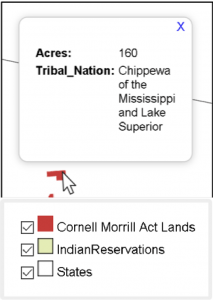
The upper right corner contains the map legend. This indicates what the various symbols on the map mean. Each parcel is indicated by a red square on the map. Current (2020) reservation lands of federally recognized tribes are shown in green. By checking or unchecking the box you can turn off the layer indicated next to the text box.
How to navigate the map
If you are using a computer:
- Left mouse click over a symbol provides a pop-up with details about the land parcel or reservation.
- Hold the left button down and drag and the map will follow, just like most on-line map apps.
- Double-click the left button and the map zooms around the point you clicked.
- The scroll wheel on your mouse zooms the map in or out.
If you are using a touchscreen device:
- Touch and drag and the map follows.
- Single tap pops up the information for the location you tapped.
- Double tap zooms centered at the point you tapped.
- Two-finger pinch zooms.
The map may be slow to respond to navigation if a large number of parcels are visible on the screen. The more you zoom in, the more responsive the map becomes.
The Cornell Morrill Act Lands Interactive Map
Map data from Robert Lee, “Morrill Act of 1862 Indigenous Land Parcels Database,” High Country News, March 2020.