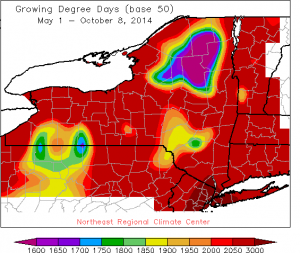
From Jessica Spaccio, NOAA Northeast Regional Climate Center, Cornell University
 Last week temperatures ranged from normal to 6 degrees above normal. Precipitation ranged from a ¼ inch to 2 inches. Base 50 growing degree-days ranged from 20 to 70.
Areas east of Lakes Erie and Ontario may see scattered lake effect rain showers today and tonight. Otherwise it will be dry with cooler than normal temperatures through Sunday for most of the state. Low pressure will bring scattered showers Friday night into Saturday morning to southeast NY areas. Possible areas of freeze Saturday night. Another chance for rain late Sunday into Monday. Monday and Tuesday will have above normal temperatures, with a chance of rain late Tuesday and cooler weather following.
The five-day precipitation amounts will range from 1/10” to ½”.
The 8-14 day outlook (Oct 16-22) is showing above normal temperatures for all of the state and above normal precipitation for all but southeast NY.
The abnormally dry area is persisting in southeast NY with a formation of Moderate Drought in and surrounding Ulster and Orange counties.
Maps of 8-14 day outlooks:
http://www.cpc.ncep.noaa.gov/products/predictions/814day/index.php
National Weather Service watch/warnings map:
http://www.erh.noaa.gov/er/hq/
NRCC Drought Page which features the US Drought Monitor map (updated every Thursday):
http://www.nrcc.cornell.edu/page_drought.html

