
NOAA Northeast Regional Climate Center, Cornell University
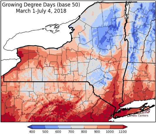
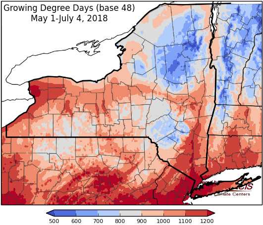
Last week temperatures ranged from 2-10 degrees above-normal. Precipitation has ranged from less than ¼ “ to over 3”. Base 50 growing degree-days ranged from 130-210. Abnormally dry conditions have been expanded for part of northern NY and the finger lake region.


Another hot day Thursday before a cold front brings storms and cooler weather.
Today temperatures will be in the mid 80s to mid 90s and muggy. Heat advisories will continue for some areas. A cold front will bring showers and thunderstorms, some possibly severe with heavy rain and flooding, mostly to central and western NY. Overnight lows will be in the mid 50s to mid 60s.
Friday will start rainy for some areas as another, stronger cold front moves through Thursday night into Friday morning, showers will diminish from west to east with cooler temperatures following. Highs will be in the 70s to low 80s. Overnight temperatures will be in the mid 40s to mid 50s.
Saturday will be sunny with temperatures in the 70s to low 80s with lower humidity. Overnight temperatures will be in the upper 40s to upper 50s. Sunday highs will be in the 70s to low 80s . Overnight temperatures will be in the upper 40s to upper 50s.
Monday temperatures will be in the mid 70s to 80s . Overnight temperatures will be in the upper 40s to upper 50s with showers and thunderstorms possible into Tuesday.
Tuesday will have temperatures in the upper 70s to 80s. Overnight temperatures will be in the 50s.
Wednesday will be dry with highs in the 80s. Overnight temperatures will be in the 50s.
The seven-day precipitation amounts will range from a trace to one inch.
The 8-14 day outlook (July 12-18) favors above-normal temperatures for all of the state. The precipitation outlook slightly favors above-normal amounts for most of the state and favors near-normal precipitation for the northeast corner of the state.
Maps of 8-14 day outlooks:
http://www.cpc.ncep.noaa.gov/products/predictions/814day/index.php
National Weather Service watch/warnings map:
http://www.weather.gov/erh/
US Drought Monitor
http://droughtmonitor.unl.edu/Home.aspx
Drought Impact Reporter:
http://droughtreporter.unl.edu/map
CLIMOD2 (NRCC data interface):
http://climodtest.nrcc.cornell.edu
