
NOAA Northeast Regional Climate Center, Cornell University
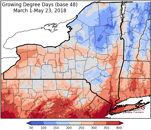
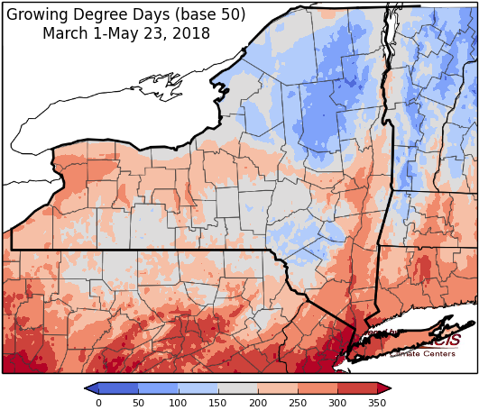
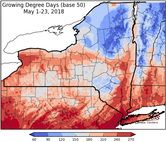
Last week temperatures ranged from 2 degrees below-normal to 8 degrees above-normal. Precipitation has ranged from ½ “ to 3 inches. Base 50 growing degree-days ranged from 10-110.

Dry and warm through Friday, showers and thunderstorms possible over the weekend.
Today will be mostly sunny with temperatures in the mid 60s to near 80. Overnight lows will be in the upper 40s and 50s.
Friday will be mostly sunny with highs in the upper 70s to mid 80s. Overnight temperatures will be in the mid 50s to mid 60s.
Saturday will be warm and humid with temperatures in the mid 70s to upper 80s, near 90 in southeast NY. Scattered showers and thunderstorms are possible, mostly in the afternoon/evening. Overnight temperatures will be in the mid 50s to low 60s.
Sunday will be humid with highs in the 70s to low 80s with showers likely, though not all day, and thunderstorms possible. Overnight temperatures will be in the mid 50s to low 60s.
Monday temperatures will be in the throughout the 70s with scattered showers and thunderstorms. Lows will be in mid 50s to low 60s.
Tuesday will have highs in the 70s and low 80s with high pressure bringing clear skies. Lows will be in the 50s.
Wednesday, temperatures will be in the 70s to low 80s. Lows will be in the upper 50s to mid 60s.
The seven-day precipitation amounts will range from ½ inch to near 2 inches.
The 8-14 day outlook (May 31-June 6) favors above-normal temperatures. The precipitation outlook favors near-normal amounts for western to central New York, and slightly favors below-normal amounts for northern, eastern and southeast New York.
Maps of 8-14 day outlooks:
http://www.cpc.ncep.noaa.gov/products/predictions/814day/index.php
National Weather Service watch/warnings map:
http://www.weather.gov/erh/
US Drought Monitor
http://droughtmonitor.unl.edu/Home.aspx
CLIMOD2 (NRCC data interface):
http://climodtest.nrcc.cornell.edu
