
From Jessica Spaccio, NOAA Northeast Regional Climate Center, Cornell University
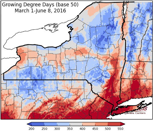
Last week temperatures ranged from 2 to 6 degrees above normal for most areas. Precipitation ranged from ¼” to 3”. Base 50 growing degree-days ranged from 60 to 140.

Below normal temperatures continue through the weekend…
Today will be cool, dry, and windy with temperatures in the 60’s to low 70’s. Overnight lows will be in the low 40’s to low 50’s.
Friday high pressure will bring another dry day with highs in the mid 60’s to low 70’s. Lows will be in the mid 40’s to low 50’s. Showers and thunderstorms are possible late Friday night into Saturday in western NY.
Saturday temperatures will be in the 70’s. Scattered showers and thunderstorms are likely with severe weather possible (damaging winds & large hail possible). Overnight temperatures will be in the 50’s.
Sunday’s highs will be in the low 60’s to mid 70’s. Overnight temperatures will be in the mid 40’s to low 50’s.
Monday temperatures will be in the 60’s to low 70’s. Lows will be in the upper 40’s to mid 50’s.
Tuesday will be in the70’s. Lows will be in the 50’s.
Wednesday temperatures will return to normal, in the mid 70’s to low 80’s, with a low chance of showers in western NY. Lows will be in50’s.
The five-day precipitation amounts will rang from 1/10” to over 1”, with the higher amounts in western NY.
The 8-14 day outlook (June 16-22) shows an increased chance for above normal temperatures for western NY and near normal temperatures are expected for the rest of the state. The precipitation outlook shows increased chances (40-50%) for below normal precipitation for the entire state.
The Drought Monitor: Abnormally dry conditions continue and have expanded. Western New York around Buffalo generally received less than a half inch of rain, which is well below normal for this time of year. Continued above-normal temperatures (4-8 degrees) combined with below-normal streamflow called for a small expansion of D0 in localized areas near the Finger Lakes.
Maps of 8-14 day outlooks:
http://www.cpc.ncep.noaa.gov/products/predictions/814day/index.php
National Weather Service watch/warnings map:
http://www.weather.gov/erh/
US Drought Monitor:
http://droughtmonitor.unl.edu/Home.aspx
CLIMOD2 (NRCC data interface):
http://climodtest.nrcc.cornell.edu
