An integrated approach to offshore wind energy assessment: Great Lakes 3D Wind Experiment. Part 2. Quantifying wind and turbulence
R.J. Barthelmie, S.C. Pryor, H. Wang, P. Crippa,D. Valyou, P. Marzocca, D. Matthiesen, D. Corrigan
Introduction
An experiment to quantify wind and turbulence was conducted at three sites near Cleveland in May 2013. The experimental design focused on high quality measurements from lidar and data integration across a range of temporal and spatial scales to quantify the flow in 3D. Data are also integrated with simulations from the Weather Research and Forecasting model (WRF).
Location
Lidar systems were deployed at the apex of a triangle extending from the port of Cleveland out to water intake crib and back to the port as shown in Figure 1. An Unmanned Aerial Vehicle (UAV) was operated from a private airstrip 12 km to the SW and from Sandusky Airport 80 km to the east.

Fig 1: Overview of the instrumentation
Lidar measurement systems
Natural Power’s ZephlR lidar uses a continuous wave laser to determine wind characteristics from the backscatter by atmospheric aerosols. The 3 ZephlR’s were operated to measure at 5 fixed heights (40, 80, 120, 160 and 200 m).
Scanning lidar (Galion) also uses the Doppler shift of radiation backscatter to determine wind characteristics but with a pulse signal. The range-gate length was 30 m and azimuthal spacing between beam products of 3° with range up to a maximum of 4 km distance/750 m height. A fixed scan was used for the whole experiment with a PPI stack followed by a VAD scan.
Sonic anemometers
A Gill anemometer was operated at the crib to quantify fluxes and stability conditions offshore and a Metek sonic was operated at the port to quantifying fluxes and stability over land.
UAV
Data from the sonic anemometer along with airspeed, components of acceleration and GPS position, heading, and ground speed were collected on the Golden Eagle (Fig. 2) and during flights of ~20-30 minutes duration.
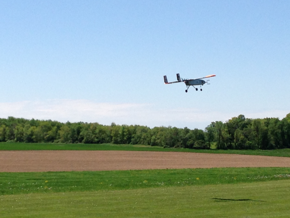
Fig 2: The Clarkson UAV in operation during the Cleveland field campaign
Data integration with WRF
WRF simulations are being run for the experiment period with 50 vertical levels, in a triple nested grid with lateral boundary conditions from the North American Mesoscale Model. The physics options selected include the Mellor-Yamada-Janjic PBL scheme, and land cover was specified at a resolution of 0.7 km.
Summary
A campaign to quantify wind and turbulence in a 3D volume offshore was successful. Data coverage and quality were exceptional.
Acknowledgements
Many thanks to the Port of Cleveland and the Cleveland Yacht Club. This material is based upon work supported by the Department of Energy under Award Number #DE-EE0005379.
Disclaimer: “This report was prepared as an account of work sponsored by an agency of the United States Government. Neither the United States Government nor any agency thereof, nor any of their employees, makes any warranty, express or implied, or assumes any legal liability or responsibility for the accuracy, completeness, or usefulness of any information, apparatus, product, or process disclosed, or represents that its use would not infringe privately owned rights. Reference herein to any specific commercial product, process, or service by trade name, trademark, manufacturer, or otherwise does not necessarily constitute or imply its endorsement, recommendation, or favoring by the United States Government or any agency thereof. The views and opinions of authors expressed herein do not necessarily state or reflect those of the United States Government or any agency thereof.”