
NOAA Northeast Regional Climate Center, Cornell University
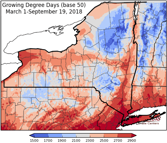
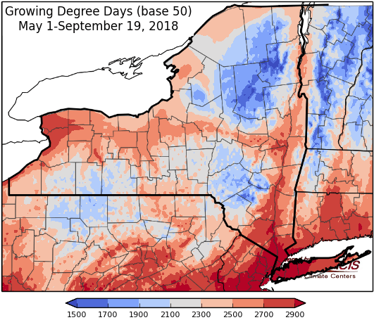
Last week temperatures were 8-12 degrees above-normal. Precipitation has ranged from less than ¼“ to over 4”. Base 50 growing degree-days ranged from 110-170.


A strong cold front will move through Friday into Friday evening, with cooler temperatures to follow.
Today temperatures will in the upper 60s and 70s with partly sunny skies. Overnight lows will be in the mid 50s to low 60s with a few light showers possible.
Friday will be in the upper 70s to 80s with showers and thunderstorms possible Friday into Friday night with a frontal passage; some storms could be severe and there is a chance for flash flooding and gusty winds. Overnight temperatures will be in the upper 40s to low 60s.
Saturday a few morning showers are possible, then a mostly dry day with temperatures in the upper 50s to near 70s. Overnight temperatures will be in the upper 40s.
Sunday highs will be in the 60s to mid 70s. Overnight temperatures will be in the mid 40s to low 50s.
Monday temperatures will be in the 60s to mid 70s with a chance of afternoon showers. Overnight temperatures will be in the 50s.
Tuesday highs will be in the 70s. Overnight temperatures will be in the 50s with overnight showers possible.
Wednesday highs will be in the 70s with showers possible. Overnight temperatures will be in the 50s.
The seven-day precipitation amounts will range from an inch to near 3 inches.
The 8-14 day outlook (Sept 26-Oct 2) slightly favors below-normal temperatures for western and northern areas and slightly favors above-normal precipitation for western, central, and northern to eastern NY.
Maps of 8-14 day outlooks:
http://www.cpc.ncep.noaa.gov/products/predictions/814day/index.php
National Weather Service watch/warnings map:
http://www.weather.gov/erh/
US Drought Monitor
http://droughtmonitor.unl.edu/Home.aspx
Drought Impact Reporter:
http://droughtreporter.unl.edu/map
CLIMOD2 (NRCC data interface):
http://climodtest.nrcc.cornell.edu
