
NOAA Northeast Regional Climate Center, Cornell University
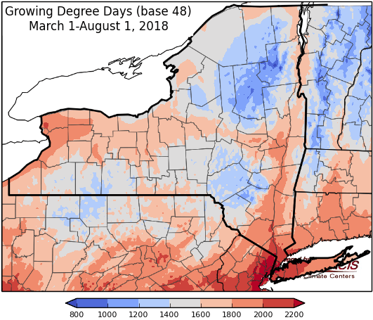
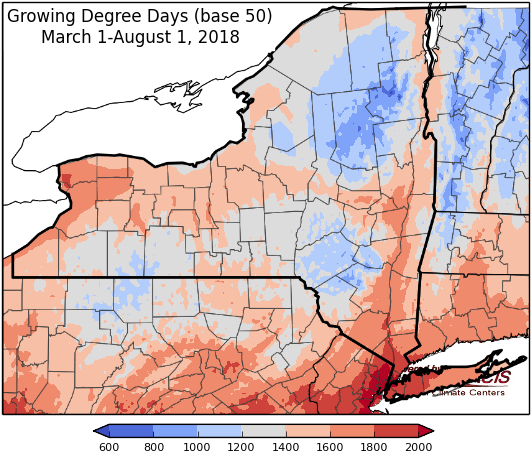
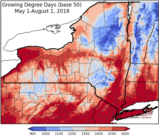
Last week temperatures were 2 degrees below-normal to 4 degrees above-normal. Precipitation has ranged from less than ¼” to near 3”. Base 50 growing degree-days ranged from 110-160. Moderate drought expanded in part of northern NY; conditions improved in much of the lower half of the state.

Humid conditions with showers and thunderstorms through the end of the week, dryer over the weekend but heat and humidity continue.
Today temperatures will be in the upper 70s and 80s with high humidity, showers and thunderstorms. There is a possibility of severe weather for some areas (damaging winds, locally heavy rain, hail, isolated tornado). Overnight lows will be in the 60s to low 70s.
Friday highs will be in the mid 70s to mid 80s with high humidity, showers and thunderstorms. The threat of flooding continues for areas that receive heavy rainfall. Overnight temperatures will be in the 60s to low 70s.
Saturday temperatures will be in the upper 70s to mid 80s , showers and thunderstorms will come to an end, western NY will be mostly dry. Overnight temperatures will be in the mid 50s to low 60s.
Sunday highs will be in the upper 70s to upper 80s with mostly dry conditions, an isolated afternoon shower or thunderstorm is possible. Overnight temperatures will be in the low to mid 60s.
Monday temperatures will be hot, in the 80s to low 90s with a slight chance of a showers or thunderstorm and continued humid conditions. Heat indices could reach mid 90s in some areas, watch for heat advisories. Overnight temperatures will be in the 60s.
Tuesday highs will be in the 80s to low 90s with high humidity, showers likely, and thunderstorms possible with the passage of a cold front. Overnight temperatures will be in the 60s.
Wednesday highs will be in the 80s with high humidity and lingering showers. Overnight temperatures will be in the 60s.
The seven-day precipitation amounts will range from three quarters of an inch to three inches.
The 8-14 day outlook (Aug 9-15) favors above-normal temperatures for all of the state and slightly favors above-normal precipitation for most of the state, excluding part of southeast NY.
Maps of 8-14 day outlooks:
http://www.cpc.ncep.noaa.gov/products/predictions/814day/index.php
National Weather Service watch/warnings map:
http://www.weather.gov/erh/
US Drought Monitor
http://droughtmonitor.unl.edu/Home.aspx
Drought Impact Reporter:
http://droughtreporter.unl.edu/map
CLIMOD2 (NRCC data interface):
http://climodtest.nrcc.cornell.edu
