
NOAA Northeast Regional Climate Center, Cornell University
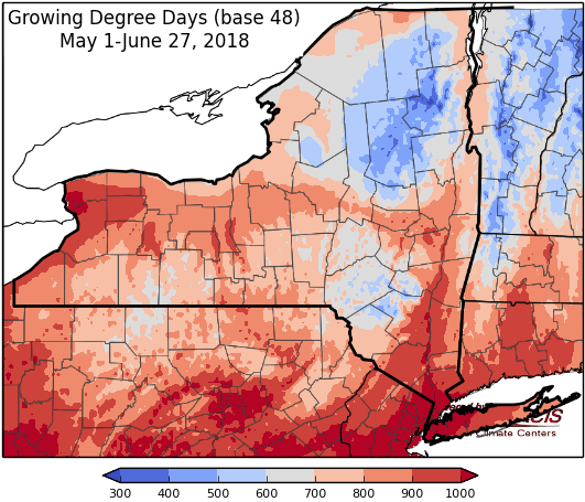
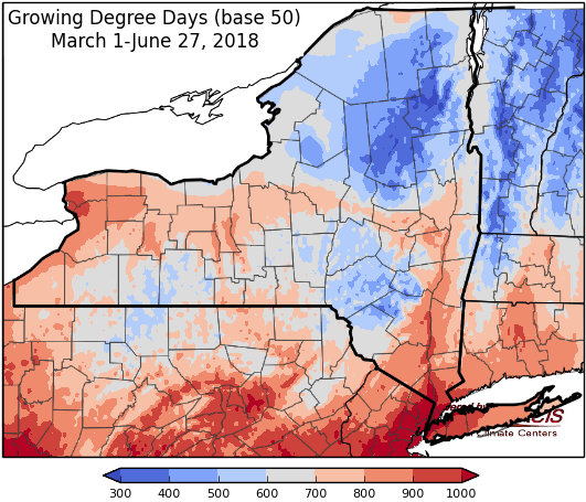
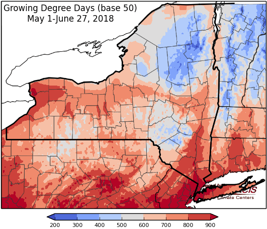
Last week temperatures ranged from 8 degrees below normal to near- normal. Precipitation has ranged from less than ¼ “ to 2”. Base 50 growing degree-days ranged from 50-130. Abnormally dry conditions have been expanded for part of central NY.

HOT and humid over the weekend.
Today rain showers and isolated thunderstorms will continue as a system moves across the state; heavy rainfall possible for the Hudson Valley Region. Showers will diminish from west to east with temperatures in the 70s to low 80s and muggy. Overnight lows will be in the mid 50s to mid 60s.
Friday will be mostly sunny and warmer with highs in the 80s to near 90, but with lower humidity. Overnight temperatures will be in the upper 50s to mid 60s.
Saturday temperatures will be in the mid 80s to mid 90s, with sunny, hot, and humid conditions. Heat indices could reach the 100s. Overnight temperatures will be in the 60s to mid 70s.
Sunday highs will be in the upper 80s and 90s, as hot & humid conditions continue. Heat indices could reach the 100s. Overnight temperatures will be in the 60s to mid 70s.
Monday temperatures will be in the 80s to mid 90s with humid conditions and a chance for scattered showers and thunderstorms. Heat indices could reach the 100s. Overnight temperatures will be in the 60s to low 70s.
Tuesday will be partly to mostly cloudy with highs will be in the upper 70s to low 90s, with humid conditions and showers and thunderstorms possible. Overnight temperatures will be in the 60s.
Wednesday will be partly to mostly cloudy with highs will be in the upper 70s to low 90s, with humid conditions and showers and thunderstorms possible. Overnight temperatures will be in the 60s.
The seven-day precipitation amounts will range from a trace to one inch.
The 8-14 day outlook (July 5-11) favors above-normal temperatures for all of the state. The precipitation outlook favors near-normal amounts.
Maps of 8-14 day outlooks:
http://www.cpc.ncep.noaa.gov/products/predictions/814day/index.php
National Weather Service watch/warnings map:
http://www.weather.gov/erh/
US Drought Monitor
http://droughtmonitor.unl.edu/Home.aspx
Drought Impact Reporter:
http://droughtreporter.unl.edu/map
CLIMOD2 (NRCC data interface):
http://climodtest.nrcc.cornell.edu
