
NOAA Northeast Regional Climate Center, Cornell University
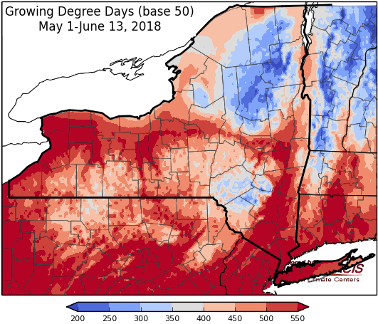
Last week temperatures ranged from 6 degrees below normal to 2 degrees above normal. Precipitation has ranged from a trace to one inch. Base 50 growing degree-days ranged from 30-110.

Monday highs will be in the 80s to mid 90s in some locations with showers and thunderstorms possible later in the day. High humidity conditions will continue, the heat index may reach upper 90s in areas of the mid-Hudson Valley. Overnight temperatures will be in the 60s.
Tuesday highs will be in the upper 70s to low 80s with a chance of showers with a frontal passage. Overnight temperatures will be in the upper 50s to mid 60s.
Wednesday highs will be in the upper 70s to low 80s. Overnight temperatures will be in the upper 50s to low 60s.
The seven-day precipitation amounts will range from a quarter of an inch to one inch.
The 8-14 day outlook (June 21-27) favors above-normal temperatures for all of the state. The precipitation outlook favors near-normal amounts for most of the state.
Maps of 8-14 day outlooks:
http://www.cpc.ncep.noaa.gov/products/predictions/814day/index.php
National Weather Service watch/warnings map:
http://www.weather.gov/erh/
US Drought Monitor
http://droughtmonitor.unl.edu/Home.aspx
CLIMOD2 (NRCC data interface):
http://climodtest.nrcc.cornell.edu
