
NOAA Northeast Regional Climate Center, Cornell University
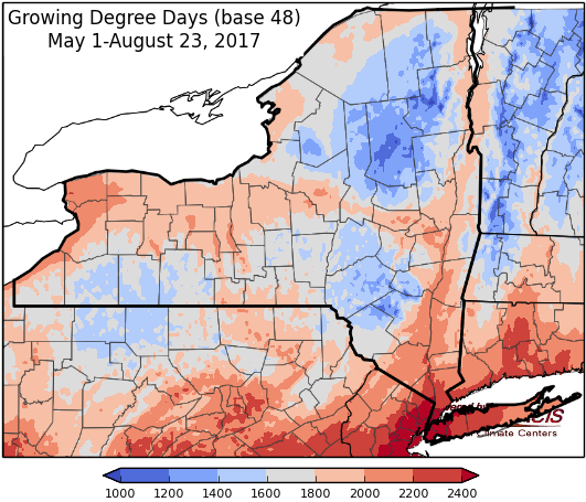
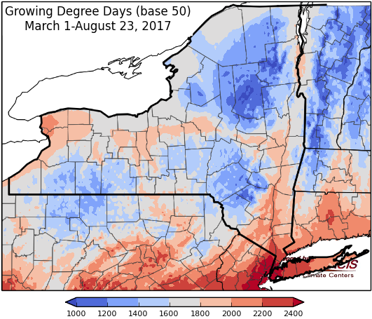
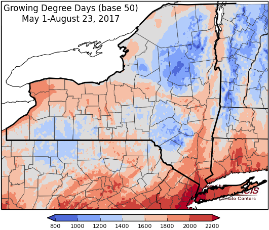
Last week temperatures ranged from normal to 4 degrees above normal. Precipitation ranged from half an inch to 3 inches, with a few isolated areas getting more than 3 inches. Base 50 growing degree-days ranged from 80 to 160.

Cooler temperatures and dry for the next week…
Today temperatures will be cooler, in the upper 60’s to upper 70’s. It will be a mostly sunny day, but a few sprinkles are possible in western to central NY. Overnight lows will be in the mid 40’s to mid 50’s.
Friday will be sunny with temperatures the mid 60’s to mid 70’s. Overnight temperatures will be in the mid 40’s to low 50’s.
Saturday’s highs will be in the upper 60’s to mid 70’ and sunny. Overnight temperatures will be in the upper 40’s to mid 50’s.
Sunday will by sunny and dry with highs throughout the 70’s. Overnight temperatures will be in the upper 40’s to mid 50’s.
Monday’s highs will be throughout the 70’s with sunny conditions. Lows will be in the upper 40’s to mid 50’s.
Tuesday will have temperatures throughout 70’s. Lows will be in the 50’s.
Wednesday, temperatures will be in the 70’s with scattered showers possible. Lows will be in the 50’s.
The seven-day precipitation amounts will range from a trace to near ¼ “.
The 8-14 day outlook (Aug 31 – Sep 6) favors below-normal temperatures for western, central, and northern NY. Southeastern areas of the state can expect near-normal temperatures. The precipitation outlook favors above-normal precipitation amounts for all but northern parts of St. Lawrence, Franklin, and Clinton counties.
Maps of 8-14 day outlooks:
http://www.cpc.ncep.noaa.gov/products/predictions/814day/index.php
National Weather Service watch/warnings map:
http://www.weather.gov/erh/
US Drought Monitor
http://droughtmonitor.unl.edu/Home.aspx
CLIMOD2 (NRCC data interface):
http://climodtest.nrcc.cornell.edu
