
NOAA Northeast Regional Climate Center, Cornell University
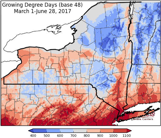
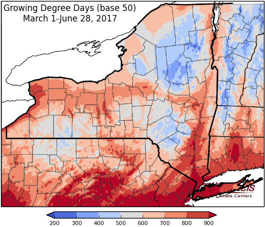
Last week temperatures ranged from near-normal to 4 degrees below normal. Precipitation ranged from a quarter inch to over 4 inches (in Jefferson County). Base 50 growing degree-days ranged from 50 to 160.


Showers and thunderstorms possible through Saturday, with humid conditions, but turning dry and seasonable Sunday and into the week…
Today temperatures be in the upper 70’s to mid 80’s. Scattered showers and thunderstorms are possible, especially in northern areas. Some storms could be severe with the threat of heavy rain, damaging winds and hail. Overnight lows will be in the 60’s.
Friday will be humid with a chance of showers and thunderstorms. Temperatures will be in the 80’s. Overnight temperatures will be in the mid 60’s to low 70’s.
Saturday’s highs will be in the 80’s, again with humid conditions and showers and thunderstorms likely. Overnight temperatures will be in the mid to upper 60’s.
Sunday, highs will be in the upper 70’s to low 80’s with a slight chance of showers and thunderstorms. Overnight temperatures will be in the upper 50’s to mid 60’s.
Monday’s highs will be in the upper 70’s to mid 80’s. Lows will be in the upper 50’s to mid 60’s.
Tuesday will have temperatures in the mid 70’s to low 80’s. Lows will be in the upper 50’s to low 60’s.
Wednesday, temperatures will be in the upper 70’s to low 80’s with scattered showers and thunderstorms possible. Lows will be in the low to mid 60’s.
The seven-day precipitation amounts will range from ½” to near 3” .
The 8-14 day outlook (July 6-12) favors above-normal temperatures and above-normal precipitation.
Maps of 8-14 day outlooks:
http://www.cpc.ncep.noaa.gov/products/predictions/814day/index.php
National Weather Service watch/warnings map:
http://www.weather.gov/erh/
US Drought Monitor
http://droughtmonitor.unl.edu/Home.aspx
CLIMOD2 (NRCC data interface):
http://climodtest.nrcc.cornell.edu
