
NOAA Northeast Regional Climate Center, Cornell University
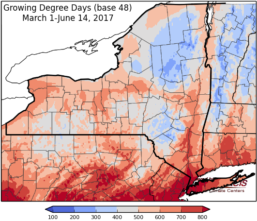
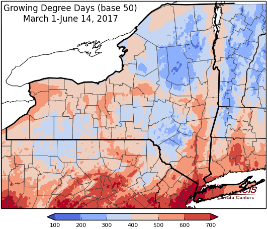
Last week temperatures ranged from 2 to 6 degrees above normal. Precipitation ranged from a trace to one inch. Base 50 growing degree-days ranged from 90 to 150.

Two frontal systems bring rain, first Thursday into Friday, second Sunday into Monday…
Today temperatures will range from the mid 70’s to low 80’s. There will be cloudy conditions and rain in western NY and around Lake Ontario, with partly cloudy and dry conditions to the east. Overnight lows will be in the mid 50’s to low 60’s with rain moving eastward with a slow moving warm front. Locally heavy rainfall associated with this front could cause minor flooding.
Friday temperatures will range from the upper 60’s in eastern areas to mid 80’s in western NY with scattered showers and thunderstorms across the state. Lows will be in the upper 50’s to mid 60’s.
Saturday scattered evening showers and thunderstorms are possible with highs in the mid 70’s to upper 80’s. Overnight temperatures will be in the 60’s and low 70’s.
Sunday, highs will be in the 80’s to near 90. Overnight temperatures will be in the 60’s. A slow moving cold front will bring showers and thunderstorms to western NY Sunday evening, slowly moving east through Monday.
Monday’s highs will be in the upper 70’s to low 80’s with scattered showers. Lows will be in upper 50’s and low 60’s.
Tuesday will have temperatures in the 70’s to low 80’s with light scattered showers possible. Lows will be in the upper 50’s to mid 60’s.
Wednesday, temperatures will be in the 70’s to low 80’s, with scattered showers possible. Lows will be in the mid 50’s to low 60’s.
The seven-day precipitation amounts will range from 1 ½“ to near 3”.
The 8-14 day outlook (June 22-28) slightly favors below-normal temperatures for central to northern NY and slightly favors above-normal precipitation for the entire state.
Maps of 8-14 day outlooks:
http://www.cpc.ncep.noaa.gov/products/predictions/814day/index.php
National Weather Service watch/warnings map:
http://www.weather.gov/erh/
US Drought Monitor
http://droughtmonitor.unl.edu/Home.aspx
CLIMOD2 (NRCC data interface):
http://climodtest.nrcc.cornell.edu
