From Jessica Spaccio, NOAA Northeast Regional Climate Center, Cornell University
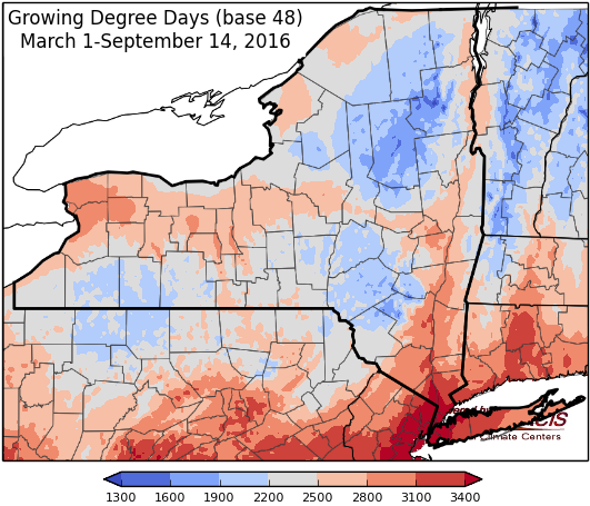
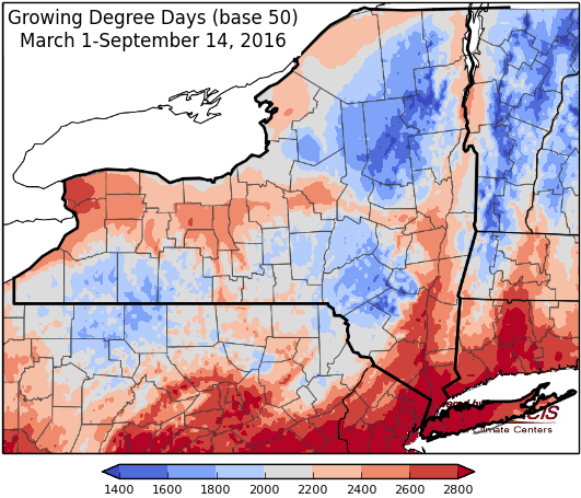
Last week temperatures ranged from 6-8 degrees above normal. Precipitation ranged from a ¼ inch to 3 inches. Base 50 growing degree-days ranged from 50 to 130.
Another day of summer weather before a cold front brings light rain and cooler temperatures…
Today will start foggy then turn sunny with above-normal temperatures in the mid 70’s to mid 80’s. Overnight lows will be in the mid 50’s to mid 60’s. A weak cold front will bring scattered showers overnight, most likely in northern areas.
Friday isolated, scattered showers and thunderstorms will move through with the front. Highs will range from the mid 60’s to upper 70’s. Lows will be in the mid 40’s to mid 50’s.
Saturday temperatures will be noticeably cooler behind the front, in the 50’s and 60’s. Overnight temperatures will be in the mid 30’s to 40’s with frost possible.
Sunday highs will be in the mid 50’s to 60’s. Overnight temperatures will be in the mid 30’s to low 40’s with frost possible.
Monday highs will be in the mid 50’s and 60’s. Lows will be in the 40’s and low 50’s with rain possible.
Tuesday temperatures will be in the upper 50’s to around 70 with a chance of rain. Lows will be in the 40’s and low 50’s.
Wednesday temperatures will be in the 60’s to around 70. Lows will be in the 40’s and low 50’s.
The five-day precipitation amounts will range from a trace to 1 ½” , with the highest amounts in northern NY.
The 8-14 day outlook (September 29 – October 5) shows increased chances for above-normal temperatures and below-normal precipitation.
The Drought Monitor: Rainfall associated with frontal passages prompted a 1-category improvement across southern Cattaraugus County in southwestern New York state, which shows up on the Advanced Hydrologic Prediction System (AHPS) 7-day observed precipitation map as southwest to northeast-oriented swaths of heavier rain. In the Lower Hudson Valley of southeastern New York, which missed out on recent rainfall, moderate drought (D1) was expanded across Dutchess and Putnam Counties.
Maps of 8-14 day outlooks:
http://www.cpc.ncep.noaa.gov/products/predictions/814day/index.php
National Weather Service watch/warnings map:
http://www.weather.gov/erh/
US Drought Monitor:
http://droughtmonitor.unl.edu/Home.aspx
CLIMOD2 (NRCC data interface):
http://climodtest.nrcc.cornell.edu


