
From Jessica Spaccio, NOAA Northeast Regional Climate Center, Cornell University
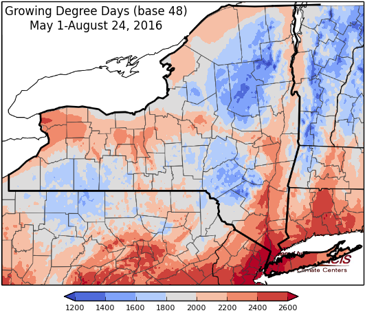
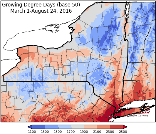
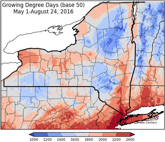
Last week temperatures ranged from near normal to more than 4 degrees above normal in parts of western and southeastern New York. Precipitation ranged from ¼ inch in parts of western New York to more than 4.5 inches in parts of eastern Long Island. Base 50 growing degree-days ranged from less than 80 in the Adirondacks to more than 160 in parts of southeastern New York.

A cold front sparks some showers Thursday, followed by dry, sunny conditions for the weekend.
Friday will feature some morning showers, mainly in the eastern half of the state. Otherwise, the day will be mostly to partly sunny with highs ranging from near 80 to near 90 degrees. Lows will be in the mid 50’s to mid 60’s for much of the state.
Saturday temperatures will be in the upper 70’s to upper 80’s, with mostly sunny skies. Overnight temperatures will be in the mid 50’s to mid 60’s for most areas.
Sunday highs will also be in the upper 70’s to upper 80’s. Expect mostly to partly sunny skies for much of the day, with a slight chance of showers late in northern and western New York. Overnight temperatures will be in the 60’s.
Monday expect partly to mostly cloudy skies with a chance showers and thunderstorms as a cold front slowly moves across the state. Highs will be in the upper 70’s to upper 80’s. Lows will be in the upper 50’s to upper 60s.
Tuesday morning there could be some lingering sprinkles in southeastern parts of the state. Otherwise, skies will be partly cloudy. Temperatures will be in the mid 70’s to mid 80’s. Lows will be in the upper 50s to mid 60s.
Wednesday temperatures will be in the mid 70’s to mid 80’s, with mostly to partly sunny skies. Lows will be in the upper 50s to mid 60s.
The five-day precipitation amounts (Aug 25-30) will range from less than 1/10” in southeastern New York up to 1.25” in parts of central and southwestern New York.
The 8-14 day outlook (August 31-September 6) shows increased chances for above normal temperatures and above normal precipitation for the entire state.
The September outlook shows no indication for above or below normal temperatures or precipitation.
The September/October/November outlook shows increased chances for above normal temperatures. There is no indication for precipitation.
The Drought Monitor: While the state did receive some rain during the past week, there was not enough precipitation to make much of a dent in drought conditions. The Drought Monitor released on August 25 shows similar conditions to last week, with 45% of the state in a drought and 41% of the state abnormally dry.
Maps of 8-14 day outlooks:
http://www.cpc.ncep.noaa.gov/products/predictions/814day/index.php
National Weather Service watch/warnings map:
http://www.weather.gov/erh/
US Drought Monitor:
http://droughtmonitor.unl.edu/Home.aspx
CLIMOD2 (NRCC data interface):
http://climodtest.nrcc.cornell.edu
