
From Jessica Spaccio, NOAA Northeast Regional Climate Center, Cornell University
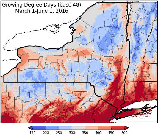
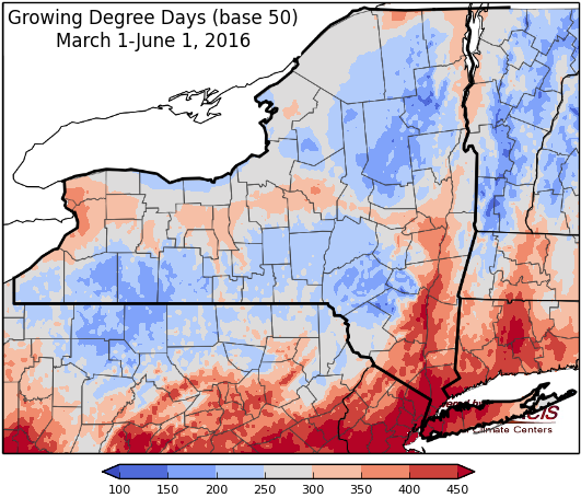
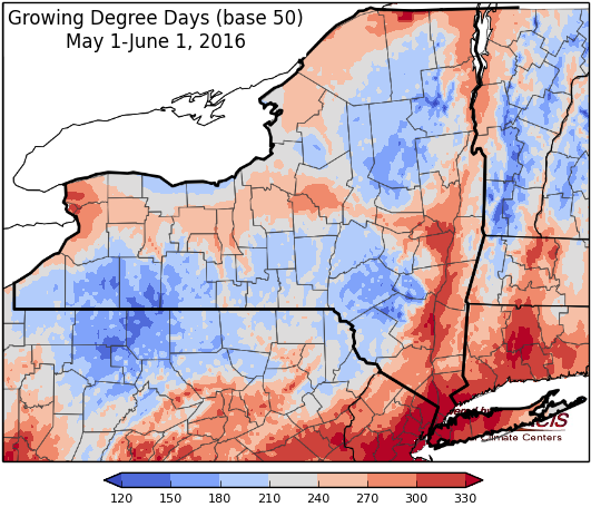
Last week was very warm with temperatures ranging from 8 to12 degrees above normal! Precipitation varied widely with some areas remaining dry with only a trace of rain, to others receiving over 1”; a few very isolated areas saw over 3” of rain. Base 50 growing degree-days ranged from 110 to 170.

Frontal system passing Thursday into Friday, dry weather for Saturday, then unsettled weather and cooler-than-normal temperatures next week. …
Friday highs will be in the upper 60’s to upper 70’s with slowly clearing conditions throughout the day west to east at the front exits. Lows will be in the upper 40’s to upper 50’s.
Saturday high pressure will bring dry weather and temperatures will be in the upper 70’s and low 80’s. Overnight temperatures will be in the upper 50’s to mid 60’s.
Sunday’s highs will be in the 70’s with showers and severe weather possible. Overnight temperatures will be in the 50’s to low 60’s.
Monday temperatures will be in the 60’s and low 70’s, southeast NY may see near 80, with afternoon showers and thunderstorms possible. Lows will be in the upper 40’s and 50’s.
Tuesday will be in the 60’s to low 70’s, with southeast NY warming into the upper 70’s, with afternoon showers and thunderstorms possible. Lows will be in the mid 40s to mid 50’s.
Wednesday will be in the mid 60’s to low 70’s. Lows will be in 50’s.
The five-day precipitation amounts will rang from ¾” to over 2” with highest amounts in Adirondacks region.
The 8-14 day outlook (June9-15) shows an increased chance for below normal temperatures for the entire state. The precipitation outlook shows increased chances of above normal precipitation for the north country and below normal precipitation for the southern Hudson Valley and Catskill region.
The Drought Monitor: Abnormally dry conditions were relieved in some areas (Essex, Monroe, Wayne, Ontario, Livingston, Montgomery, Schoharie counties) that received rain from spotty showers and thunderstorms; other areas that missed the rains (western NY around Buffalo, Cayuga, Onondaga) are now included in the abnormally dry conditions.
Maps of 8-14 day outlooks:
http://www.cpc.ncep.noaa.gov/products/predictions/814day/index.php
National Weather Service watch/warnings map:
http://www.erh.noaa.gov/er/hq/
US Drought Monitor:
http://droughtmonitor.unl.edu/Home.aspx
CLIMOD2 (NRCC data interface):
http://climodtest.nrcc.cornell.edu
