
From Jessica Spaccio, NOAA Northeast Regional Climate Center, Cornell University
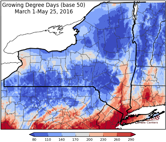
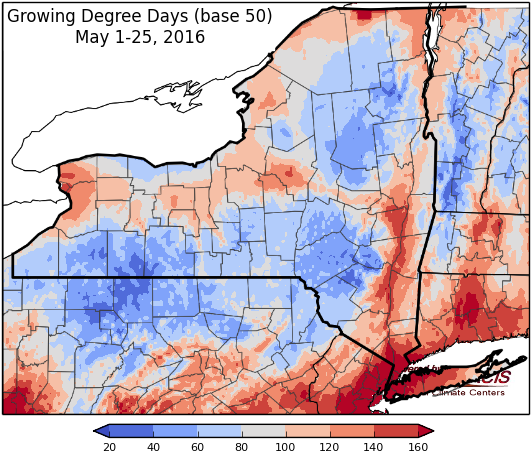
Last week temperatures ranged from 4 degrees below normal to 2 degrees above normal. Precipitation was less than an inch for the state, with most areas seeing less than ¼”. Base 50 growing degree-days ranged from 20 to 70.
![GDD48_Mar1_May25[1]](https://blogs.cornell.edu/ccefieldcropnews/files/2016/05/GDD48_Mar1_May251-wu10j5.png)

Summer-like weather (warm, humid, afternoon thunderstorms)…
Today mostly sunny and warm with temperatures will in the upper 70’s and 80’s. Isolated afternoon showers and thunderstorms are likely. Overnight lows will be in the upper 50’s and 60’s.
Friday will be mostly sunny and warm again in the 80’s, even 90 possible. Scattered thunderstorms are possible in the afternoon. Lows will be in the upper 50’s and 60’s.
Saturday temperatures will be in the upper 70’s to 80’s, 90 possible, with isolated afternoon showers and thunderstorms. Overnight temperatures will be in the mid to upper 60’s.
Sunday’s highs will be in the mid 70’s to mid 80’s. Isolated afternoon showers and thunderstorms are possible. Overnight temperatures will be in the mid 50’s to low 60’s.
Monday temperatures will be slightly cooler in the 70’s, some low 80’s, with an increased chance of showers and thunderstorms from a cold front. Lows will be in the mid 50’s to low 60’s.
Tuesday will be in the mid 70’s to low 80’s with a continued chance of showers and thunderstorms. Lows will be in the upper 50’s to low 60’s.
Wednesday will be in the 70’s and some low 80’s possible. Lows will be in upper 50’s to low 60’s.
The five-day precipitation amounts will range ¼” to over 1 ½”.
The 8-14 day outlook (June2-8) shows equal chances for above or below normal temperatures fro all but the southeast corner of the state that has an increased chance (33-40%) of below normal temperatures. Most of the state has an increased chance (33-40%) of above normal precipitation.
June outlook shows increased chances (40-50%) of above normal temperatures for the entire state. There are equal chances of above or below normal precipitation.
The June/July/August outlook shows increased chances (50-60%) of above normal temperatures for the entire state. There is an increased chance (33-40%)for above normal precipitation in the northeast portion of the state.
The Drought Monitor: Abnormally dry conditions have expanded in the Adirondacks due to short-term precipitation deficits, low streamflows, and dry soils.
Maps of 8-14 day outlooks:
http://www.cpc.ncep.noaa.gov/products/predictions/814day/index.php
National Weather Service watch/warnings map:
|http://www.erh.noaa.gov/er/hq/
US Drought Monitor:
http://droughtmonitor.unl.edu/Home.aspx
CLIMOD2 (NRCC data interface):
http://climodtest.nrcc.cornell.edu
