
From Jessica Spaccio, NOAA Northeast Regional Climate Center, Cornell University
Last week temperatures were below normal again, by 2 to 4 degrees across most of the state. Precipitation ranged from less than ¼ inch in western NY to over 1 inch in a few isolated areas. Base 50 growing degree-days ranged from near zero to over 20.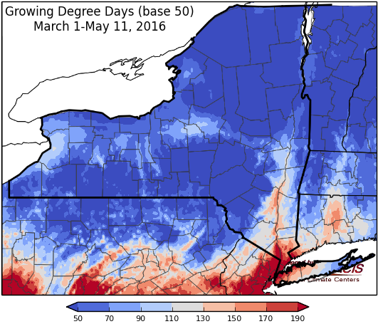

Warm & dry Thursday, then turning cooler & unsettled…
Today high pressure will provide dry and sunny conditions. Temperatures will be above normal, throughout the 70’s and some areas reaching 80. Afternoon thunderstorms are possible in western areas as a cold front approaches and will bring overnight showers moving west to east over the state.
Overnight lows will be in the mid 40’s and 50’s.
Friday will be cloudy with rain likely as the cold front passes. Highs will be in the 60’s, with some low 70’s. Eastern areas of the state will warm before the front moves in. Lows will be in the mid 40’s to low 50’s.
Saturday will be cloudy with showers as another cold front moves through. Temperatures will be in the mid 50’s to low 60’s, eastern areas will reach upper 60’s. Overnight temperatures will be in the mid 30’s to 40’s with light wet snow possible.
Sunday will be partly cloudy and cooler yet with highs only in the mid 40’s to mid 50’s. Showers are still possible as they move out of the state. Overnight temperatures will be in the mid 30’s to 40’s.
Monday temperatures will be in the mid 50’s to mid 60’s. Lows will be in the mid 30’s to low 40’s.
Tuesday will be in the upper 50’s to low 60’s. Lows will be in the mid 30’s to mid 40’s.
Wednesday will be in the mid to upper 60’s. Lows will be in the 40’s.
The five-day precipitation amounts will range from ½ to ¾ inch in the Catskill/southern Hudson Valley region up to 2 inches in northern NY.
The 8-14 day outlook (May 19-25) shows increased chances for above normal temperatures in western NY and equal chances of above or below normal temperatures for the rest of the state. Near normal precipitation is espected for the entire state.
The Drought Monitor: Abnormally dry conditions have expanded in the Hudson Valley/Eastern Plateau regions and a new area was added in northern NY.
Maps of 8-14 day outlooks:
http://www.cpc.ncep.noaa.gov/products/predictions/814day/index.php
National Weather Service watch/warnings map:
http://www.erh.noaa.gov/er/hq/
US Drought Monitor:
http://droughtmonitor.unl.edu/Home.aspx
CLIMOD2 (NRCC data interface):
http://climodtest.nrcc.cornell.edu
