
From Jessica Spaccio, NOAA Northeast Regional Climate Center, Cornell University
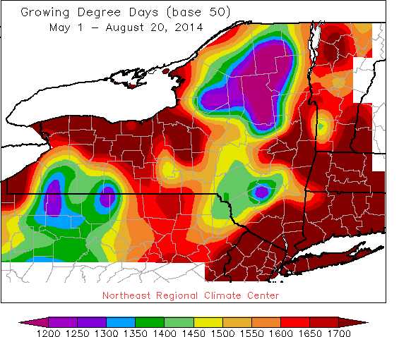 Last week temperatures ranged from 4 to 8 degrees below normal. Precipitation ranged from ¼ ” to over 2’. Base 50 growing degree-days ranged from 40 to 120.
Cloudy and rainy couple of days gives way to nice, dry weather Saturday through Wednesday.
Today will be cloudy with showers and thunderstorms with localized heavy rain; temperatures will be in the mid to upper 70’s. Overnight temperatures will be in the upper 50’s and low 60’s.
Friday will be mostly cloudy with temperatures in the mid to upper 70’s with scattered showers and thunderstorms possible, a few could be strong. Low temperatures will be in the upper 50’s to low 60’s.
Saturday will be partly sunny as high pressure returns, with a small chance of showers and temperatures throughout the 70’s. Overnight temperatures will be in the mid 50’s to low 60’s.
Sunday will be partly sunny with highs throughout the 70’s. Overnight temperatures will be in the mid 50’s and low 60’s.
Monday will be partly sunny with highs in the mid 70’s to near 80. Overnight temperatures will be in the mid 50’s to low 60’s.
Tuesday will be partly sunny with highs in the mid 70’s to low 80’s. Lows will be in the mid 50’s to low 60’s.
Wednesday’s highs will be in the mid 70’s and low 80’s. Lows will be in the upper 50’s and low 60’s.
The five-day precipitation amounts will range from ¼” to 1 ½ ” ; 7-day amounts will range from ¼” to 1 ½ ”.
The 8-14 day outlook (Aug 28 – Sept 3) is showing below normal temperatures or all but eastern NY and above normal precipitation.
Maps of 8-14 day outlooks:
http://www.cpc.ncep.noaa.gov/products/predictions/814day/index.php
National Weather Service watch/warnings map:
http://www.erh.noaa.gov/er/hq/
NRCC Drought Page which features the US Drought Monitor map (updated every Thursday):
http://www.nrcc.cornell.edu/page_drought.html
