
From Jessica Spaccio, NOAA Northeast Regional Climate Center, Cornell University
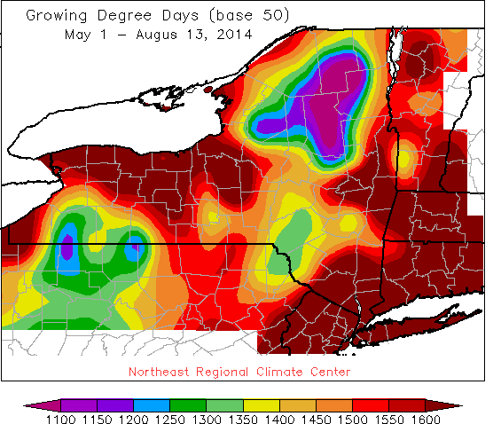 Last week temperatures ranged from normal to 4 degrees below normal. Precipitation ranged from ½” to over 3”, most coming from the Tuesday/Wednesday cold front passage. Base 50 growing degree-days ranged from 80 to 140.
Cool Thursday & Friday, warming over the weekend.
Today will be partly cloudy with cool temperatures in the mid 60’s to low 70’s. Isolated scattered showers are possible, more likely downwind of Lake Erie & Ontario due to lake enhanced activity; some locally heavy rain possible overnight in these regions. Overnight temperatures will be in the upper 40’s to the low50’s.
Friday will be mostly cloudy, again with cool temperatures in the 60’s and low 70’s with a few scattered showers possible but decreasing through the day. Low temperatures will be in the mid 40’s to 50’s.
Saturday high pressure will bring mostly sunny conditions with highs a bit warmer, upper 60’s and throughout the 70’s. Overnight temperatures will be in the mid 50’s to low 60’s. Low pressure will bring scattered showers and thunderstorms overnight Saturday into Sunday.
Sunday will be mostly cloudy with highs in the mid 70’s to low 80’s and a chance of showers and thunderstorms. Overnight temperatures will be in the mid 50’s and low 60’s.
Monday will be mostly sunny with highs in the upper 70’s and low 80’s. Overnight temperatures will be in the mid 50’s to low 60’s.
Tuesday will be mostly sunny with highs in the upper 70’s to low 80 with scattered showers and thunderstorms possible. Lows will be in the mid to upper 50’s.
Wednesday’s highs will be in the upper 70’s and low 80’s with scattered showers and thunderstorms possible. Lows will be in the upper 50’s and low 60’s.
The five-day precipitation amounts will range from ¼” to 1” ; 7-day amounts will range from ¾” to 1 ½” .
The 8-14 day outlook (Aug 21-27) is showing above normal temperatures; and above normal precipitation.
Maps of 8-14 day outlooks:
http://www.cpc.ncep.noaa.gov/products/predictions/814day/index.php
National Weather Service watch/warnings map:
http://www.erh.noaa.gov/er/hq/
NRCC Drought Page which features the US Drought Monitor map (updated every Thursday):
http://www.nrcc.cornell.edu/page_drought.html
